
קובץ:Europe 1815 map en.png

גודל התצוגה המקדימה הזאת: 800 × 526 פיקסלים. רזולוציות אחרות: 320 × 211 פיקסלים | 640 × 421 פיקסלים | 1,024 × 674 פיקסלים | 1,280 × 842 פיקסלים | 2,284 × 1,503 פיקסלים.
לקובץ המקורי (2,284 × 1,503 פיקסלים, גודל הקובץ: 1.08 מ"ב, סוג MIME: image/png)
| זהו קובץ שמקורו במיזם ויקישיתוף. תיאורו בדף תיאור הקובץ המקורי (בעברית) מוצג למטה. |
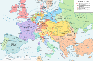
Map of Europe 1815, After the Congress of Vienna.
תקציר
| תיאור |
English: Europe 1815. Political situation after the Congress of Vienna in June 1815. Please don't alter the map when you think there is something not written or depicted correctly. Leave a message at the talk page of the file. After a verificiation and a possible discussion, I will upload a new map version with all new changes. This prevents an unnecessary waste of disk space and ensures a good result, aesthetically and content-wise. - The author. Español: Mapa de Europa en 1815. Situación política tras el Congreso de Viena en junio de 1815.
Deutsch: Europa 1815. Politische Lage nach dem Wiener Kongress im Juni 1815.
Bitte die Karte bei Änderungs- und Korrekturwünschen nicht selbst verändern, sondern eine Anmerkung im Diskussionsbereich der Bilddatei hinterlassen. Nach einer Prüfung und ggfs. Diskussion werden evtl. Änderungen von mir zusammengefasst eingearbeitet. Das vermeidet unnötige Speicherplatz-Verschwendung und gewährleistet ein ästhetisch ansprechendes und inhaltlich korrektes Ergebnis. - Der Urheber. Français : Carte de l'Europe en 1815. Situation politique après le Congrès de Vienne en juin 1815.
Italiano: Mappa dell'Europa nel 1815. Situazione politica dopo il Congresso di Vienna nel giugno 1815.
Русский: Карта Европы 1815 года. Политическая ситуация после Венского конгресса в июне 1815 года.
Português: Mapa da Europa em 1815. Situação política após o Congresso de Viena em junho de 1815. |
| תאריך יצירה | |
| מקור |
נוצר על־ידי מעלה היצירה. Source of Information: Historical atlases – Map "1815 - L'Europe après le Congrès de Vienne" (Author unknown)(Link) – Ramsay Muir, George Philip (ed.): Philip's New School Atlas of Universal History, George Philip & Son, Ltd., London 1928 – Dr. Walter Leisering (ed.): Putzger Historischer Weltatlas, Cornelsen Verlag, Berlin 1992, ISBN 3-464-00176-8 – Bayerischer Schulbuch-Verlag (ed.): Großer Historischer Weltatlas, Dritter Teil, Neuzeit, Bayerischer Schulbuch-Verlag, München 1981, ISBN 3-7627-6021-7. – Prof. Dr. Hans-Erich Stier, Prof. Dr. Ernst Kirsten a. o. (ed.): Großer Atlas zur Weltgeschichte, Orbis Verlag, München 1990, ISBN 3-7627-6021-7 Other publications – Reinhard Stauber: Der Wiener Kongress, Böhlau Verlag, Wien/Köln/Weimar 2014, ISBN 978-3-8252-4095-0 – Thierry Lentz: 1815. Der Wiener Kongress und die Neugründung Europas, Siedler Verlag, München 2014, ISBN 978-3-8275-0027-4 |
| יוצר | Alexander Altenhof |
| גרסאות אחרות |
|

Recompressed without quality loss with OptiPNG (1.36 MB > 1.06 MB)
רישיון
אני, בעל זכויות היוצרים על עבודה זו, מפרסם בזאת את העבודה תחת הרישיון הבא:
הקובץ הזה מתפרסם לפי תנאי רישיון קריאייטיב קומונז ייחוס-שיתוף זהה 4.0 בין־לאומי.
- הנכם רשאים:
- לשתף – להעתיק, להפיץ ולהעביר את העבודה
- לערבב בין עבודות – להתאים את העבודה
- תחת התנאים הבאים:
- ייחוס – יש לתת ייחוס הולם, לתת קישור לרישיון, ולציין אם נעשו שינויים. אפשר לעשות את זה בכל צורה סבירה, אבל לא בשום צורה שמשתמע ממנה שמעניק הרישיון תומך בך או בשימוש שלך.
- שיתוף זהה – אם תיצרו רמיקס, תשנו, או תבנו על החומר, חובה עליכם להפיץ את התרומות שלך לפי תנאי רישיון זהה או תואם למקור.

|
יש ליצור מחדש את התמונה map הזו באמצעות גרפיקה וקטורית כדוגמת קובץ SVG. לפעולה זו מספר יתרונות, כפי שניתן לקרוא (באנגלית) בדף Commons:Media for cleanup. אם ברשותכם קובץ SVG, אנא העלו אותו. לאחר מכן, החליפו תבנית זו בתבנית
{{vector version available|שם הקובץ.svg}} |
היסטוריית הקובץ
ניתן ללחוץ על תאריך/שעה כדי לראות את הקובץ כפי שנראה באותו זמן.
| תאריך/שעה | תמונה ממוזערת | ממדים | משתמש | הערה | |
|---|---|---|---|---|---|
| נוכחית | 02:36, 15 באפריל 2017 | | 1,503 × 2,284 (1.08 מ"ב) | KaterBegemot | Corrected "K. of Bavaria" caption / minor changes |
| 00:50, 12 בספטמבר 2016 |  | 1,503 × 2,284 (1.36 מ"ב) | KaterBegemot | Kingdom of Spain same green color like in the other maps | |
| 00:38, 12 בספטמבר 2016 |  | 1,503 × 2,284 (1.06 מ"ב) | KaterBegemot | Deleted black border at Austrian part of the German Confederation border, P. of Monaco smaller, corrected border at Tarnopol area, changed spacing of K. of Netherlands text | |
| 14:23, 20 ביולי 2016 |  | 1,503 × 2,284 (1.07 מ"ב) | KaterBegemot | {{Information |Description ={{en|1=Europe 1815. Political situation after the Congress of Vienna in June 1815.<br> ''Please don't alter the map, when you think there something not written or depicted correclty. Leave a mes... |
שימוש בקובץ
הדפים הבאים משתמשים בקובץ הזה:
שימוש גלובלי בקובץ
אתרי הוויקי השונים הבאים משתמשים בקובץ זה:
- שימוש באתר avk.wikipedia.org
- שימוש באתר azb.wikipedia.org
- שימוש באתר bg.wikipedia.org
- שימוש באתר bs.wikipedia.org
- שימוש באתר cs.wikipedia.org
- שימוש באתר da.wikipedia.org
- שימוש באתר el.wikipedia.org
- שימוש באתר eml.wikipedia.org
- שימוש באתר en.wikipedia.org
- Europe
- History of Europe
- 1810s
- History of Austria
- Congress of Vienna
- Napoleonic Wars
- History of the Czech lands
- Klemens von Metternich
- Karl August von Hardenberg
- Concert of Europe
- Former countries in Europe after 1815
- Balance of power (international relations)
- Monarchies in Europe
- Federal Convention (German Confederation)
- Portal:Czech Republic
- European balance of power
- 19th century
- International relations (1814–1919)
- Timeline of Karl Marx
- Timeline of the 19th century
- User:Falcaorib
- Secret Treaty of Vienna
- Talk:Europe/Archive 11
- User:SocratesGR
- שימוש באתר en.wikibooks.org
- שימוש באתר en.wikiquote.org
- שימוש באתר eo.wikipedia.org
- שימוש באתר eo.wikiquote.org
- שימוש באתר es.wikipedia.org
- שימוש באתר et.wikipedia.org
- שימוש באתר eu.wikipedia.org
- שימוש באתר fa.wikipedia.org
- שימוש באתר fi.wikipedia.org
- שימוש באתר fr.wikipedia.org