
קובץ:FederalTriangle WashingtonDC 2009.jpg
גודל התצוגה המקדימה הזאת: 800 × 546 פיקסלים. רזולוציות אחרות: 320 × 218 פיקסלים | 640 × 437 פיקסלים | 1,024 × 699 פיקסלים | 1,480 × 1,010 פיקסלים.
לקובץ המקורי (1,480 × 1,010 פיקסלים, גודל הקובץ: 524 ק"ב, סוג MIME: image/jpeg)
| זהו קובץ שמקורו במיזם ויקישיתוף. תיאורו בדף תיאור הקובץ המקורי (בעברית) מוצג למטה. |

|
יש ליצור מחדש את התמונה city map הזו באמצעות גרפיקה וקטורית כדוגמת קובץ SVG. לפעולה זו מספר יתרונות, כפי שניתן לקרוא (באנגלית) בדף Commons:Media for cleanup. אם ברשותכם קובץ SVG, אנא העלו אותו. לאחר מכן, החליפו תבנית זו בתבנית
{{vector version available|שם הקובץ.svg}} |


תקציר
| תיאור |
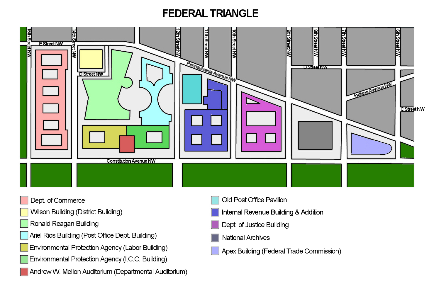
English: Diagram of the Federal Triangle area of Washington, D.C., as of December 2009. Each of the federal government buildings in the area is color-coded and described according to the diagram legend. |
| תאריך יצירה | |
| מקור | נוצר על־ידי מעלה היצירה |
| יוצר | Tim1965 |
רישיון
אני, בעל זכויות היוצרים על עבודה זו, מפרסם בזאת את העבודה תחת הרישיון הבא:
הקובץ הזה מתפרסם לפי תנאי רישיון קריאייטיב קומונז ייחוס 3.0 לא מותאם.
- הנכם רשאים:
- לשתף – להעתיק, להפיץ ולהעביר את העבודה
- לערבב בין עבודות – להתאים את העבודה
- תחת התנאים הבאים:
- ייחוס – יש לתת ייחוס הולם, לתת קישור לרישיון, ולציין אם נעשו שינויים. אפשר לעשות את זה בכל צורה סבירה, אבל לא בשום צורה שמשתמע ממנה שמעניק הרישיון תומך בך או בשימוש שלך.
היסטוריית הקובץ
ניתן ללחוץ על תאריך/שעה כדי לראות את הקובץ כפי שנראה באותו זמן.
| תאריך/שעה | תמונה ממוזערת | ממדים | משתמש | הערה | |
|---|---|---|---|---|---|
| נוכחית | 07:14, 5 בדצמבר 2009 | | 1,010 × 1,480 (524 ק"ב) | Tim1965 | {{Information |Description={{en|1=Diagram of the Federal Triangle area of Washington, D.C., as of December 2009. Each of the federal government buildings in the area is color-coded and described according to the diagram legend.}} |Source={{own}} |Author=[ |
שימוש בקובץ
הדף הבא משתמש בקובץ הזה:
שימוש גלובלי בקובץ
אתרי הוויקי השונים הבאים משתמשים בקובץ זה:
- שימוש באתר de.wikipedia.org
- שימוש באתר en.wikipedia.org
- שימוש באתר www.wikidata.org
- שימוש באתר zh.wikipedia.org