
קובץ:Fertile Crescent map.png

גודל התצוגה המקדימה הזאת: 488 × 600 פיקסלים. רזולוציות אחרות: 195 × 240 פיקסלים | 391 × 480 פיקסלים | 625 × 768 פיקסלים | 833 × 1,024 פיקסלים | 1,988 × 2,443 פיקסלים.
לקובץ המקורי (1,988 × 2,443 פיקסלים, גודל הקובץ: 717 ק"ב, סוג MIME: image/png)
| זהו קובץ שמקורו במיזם ויקישיתוף. תיאורו בדף תיאור הקובץ המקורי (בעברית) מוצג למטה. |
{{subst:proposed deletion|concern=Incorrect details as well as political motivated terms. See discussion please remove image}}

|
קיימת תמונה חדשה תמונה זו בגרסה וקטורית בפורמט "SVG". יש להחליף את התמונה הנוכחית בתמונה החדשה.
File:Fertile Crescent map.png → File:Map of fertile crescent.svg
למידע נוסף אודות גרפיקה וקטורית, אנא קראו אודות המעבר של ויקישיתוף לתמונות בפורמט SVG. ראו גם מידע אודות התמידה של מדיה-ויקי בתמונות בפורמט SVG. |
 |
תקציר
| תיאור |
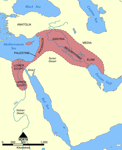
English: This map shows the location and extent of the Fertile Crescent, a region in the Middle East incorporating Ancient Egypt; the Levant; and Mesopotamia.
Français : Carte en anglais du Croissant fertile, région du Moyen-Orient incluant l'Égypte antique, le Levant et la Mésopotamie où a débuté la civilisation. |
| תאריך יצירה | |
| מקור |
נוצר על־ידי מעלה היצירה This image was based on a similar map from the 1994 edition of the Encyclopedia Britannica. |
| יוצר | User:NormanEinstein |
| גרסאות אחרות |
[]
See also:
|


רישיון
אני, בעל זכויות היוצרים על היצירה הזאת, מפרסם אותה בזאת תחת הרישיונות הבאים:

|
מוענקת בכך הרשות להעתיק, להפיץ או לשנות את המסמך הזה, לפי תנאי הרישיון לשימוש חופשי במסמכים של גנו, גרסה 1.2 או כל גרסה מאוחרת יותר שתפורסם על־ידי המוסד לתוכנה חופשית; ללא פרקים קבועים, ללא טקסט עטיפה קדמית וללא טקסט עטיפה אחורית. עותק של הרישיון כלול בפרק שכותרתו הרישיון לשימוש חופשי במסמכים של גנו. |
| הקובץ הזה מתפרסם לפי תנאי רישיון קריאייטיב קומונז ייחוס-שיתוף זהה 3.0 לא מותאם. | ||
| ||
| תבנית רישוי זו הוספה לקובץ כחלק מעדכון רישיון GFDL. |
הנכם מוזמנים לבחור את הרישיון הרצוי בעיניכם.
derivative works
Derivative works of this file:
היסטוריית הקובץ
ניתן ללחוץ על תאריך/שעה כדי לראות את הקובץ כפי שנראה באותו זמן.
| תאריך/שעה | תמונה ממוזערת | ממדים | משתמש | הערה | |
|---|---|---|---|---|---|
| נוכחית | 21:28, 17 ביוני 2010 | | 2,443 × 1,988 (717 ק"ב) | Ras67 | cropped and squeezed |
| 23:30, 21 בדצמבר 2005 |  | 2,454 × 2,000 (990 ק"ב) | NormanEinstein | This map shows the location and extent of the '''Fertile Crescent''', a region in the Middle East incorporating Ancient Egypt, the Levant, and Mesopotamia where civilisation started. Created by NormanEinstein, December 21, 2005. {{GFDL-self}} [[Categor |
שימוש בקובץ
הדף הבא משתמש בקובץ הזה:
שימוש גלובלי בקובץ
אתרי הוויקי השונים הבאים משתמשים בקובץ זה:
- שימוש באתר azb.wikipedia.org
- שימוש באתר az.wikipedia.org
- שימוש באתר bg.wikipedia.org
- שימוש באתר bn.wikipedia.org
- שימוש באתר cs.wikipedia.org
- שימוש באתר en.wikipedia.org
- שימוש באתר en.wikiversity.org
- שימוש באתר en.wiktionary.org
- שימוש באתר et.wikipedia.org
- שימוש באתר fa.wikipedia.org
- שימוש באתר fi.wikipedia.org
- שימוש באתר fr.wikipedia.org
- שימוש באתר gl.wikipedia.org
- שימוש באתר hu.wikipedia.org
- שימוש באתר id.wikipedia.org
- שימוש באתר it.wikipedia.org
- שימוש באתר ko.wikipedia.org
- שימוש באתר lv.wikipedia.org
- שימוש באתר mk.wikipedia.org
- שימוש באתר mwl.wikipedia.org
- שימוש באתר nn.wikipedia.org
- שימוש באתר no.wikipedia.org
- שימוש באתר pl.wikipedia.org
- שימוש באתר pl.wiktionary.org
- שימוש באתר pt.wikibooks.org
- שימוש באתר ro.wikipedia.org
- שימוש באתר sh.wikipedia.org
- שימוש באתר simple.wikipedia.org
- שימוש באתר sk.wikipedia.org
- שימוש באתר sq.wikipedia.org
- שימוש באתר sv.wikipedia.org