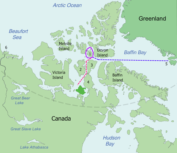
קובץ:Franklin's lost expedition map.png
מראה
Franklin's_lost_expedition_map.png (602 × 520 פיקסלים, גודל הקובץ: 121 ק"ב, סוג MIME: image/png)
היסטוריית הקובץ
ניתן ללחוץ על תאריך/שעה כדי לראות את הקובץ כפי שנראה באותו זמן.
| תאריך/שעה | תמונה ממוזערת | ממדים | משתמש | הערה | |
|---|---|---|---|---|---|
| נוכחית | 16:52, 6 ביוני 2009 |  | 520 × 602 (121 ק"ב) | Like tears in rain | Trying to remove border |
| 02:12, 24 ביולי 2008 |  | 536 × 668 (114 ק"ב) | Finetooth | {{Information |Description={{en|1={{en|Map of the probable routes taken by ''Erebus'' and ''Terror'' during Franklin's lost expedition. {{legend|blue|Disko Bay (5) to Beechey Island, in 1845}} {{legend|purple|Around Cornwallis Island (1), in 1845}} { |
שימוש בקובץ
![]() אין בוויקיפדיה דפים המשתמשים בקובץ זה.
אין בוויקיפדיה דפים המשתמשים בקובץ זה.
שימוש גלובלי בקובץ
אתרי הוויקי השונים הבאים משתמשים בקובץ זה:
- שימוש באתר bg.wikipedia.org
- שימוש באתר ca.wikipedia.org
- שימוש באתר da.wikipedia.org
- שימוש באתר en.wikipedia.org
- שימוש באתר es.wikipedia.org
- שימוש באתר eu.wikipedia.org
- שימוש באתר fi.wikipedia.org
- שימוש באתר fr.wikipedia.org
- שימוש באתר hu.wikipedia.org
- שימוש באתר id.wikipedia.org
- שימוש באתר it.wikipedia.org
- שימוש באתר ja.wikipedia.org
- שימוש באתר ms.wikipedia.org
- שימוש באתר nn.wikipedia.org
- שימוש באתר no.wikipedia.org
- שימוש באתר pt.wikipedia.org
- שימוש באתר ro.wikipedia.org
- שימוש באתר sr.wikipedia.org
- שימוש באתר sv.wikipedia.org
- שימוש באתר tr.wikipedia.org
- שימוש באתר vi.wikipedia.org
- שימוש באתר www.wikidata.org


