
קובץ:Great Basin definition map.gif

גודל התצוגה המקדימה הזאת: 437 × 599 פיקסלים. רזולוציות אחרות: 175 × 240 פיקסלים | 572 × 784 פיקסלים.
לקובץ המקורי (572 × 784 פיקסלים, גודל הקובץ: 50 ק"ב, סוג MIME: image/gif)
| זהו קובץ שמקורו במיזם ויקישיתוף. תיאורו בדף תיאור הקובץ המקורי (בעברית) מוצג למטה. |
תקציר
| תיאור |
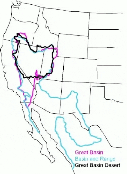
English: The Great Basin can be defined hydrographically (in purple), topographically (in blue), or biologically (in black). |
| תאריך יצירה | (UTC) |
| מקור |
קובץ זה הוא יצירה נגזרת של: GB-Definition-Map.jpg:  |
| יוצר |
|
רישיון
Original:
| This image or media file contains material based on a work of a National Park Service employee, created as part of that person's official duties. As a work of the U.S. federal government, such work is in the public domain in the United States. See the NPS website and NPS copyright policy for more information. |
Cleanup:
| קובץ זה זמין לפי תנאי הקדשה עולמית לנחלת הכלל CC0 1.0 של Creative Commons. | |
| האדם ששייך יצירה להיתר הזה הקדיש את היצירה לנחלת הכלל על־ידי ויתור על כל הזכויות שלו או שלה על היצירה בכל העולם לפי חוק זכויות יוצרים, לרבות כל הזכויות הקשורות או הסמוכות כקבוע בחוק. באפשרותך להעתיק, לשנות, להפיץ, או להציג את היצירה, אפילו למטרות מסחריות, וכל זה אפילו מבלי לבקש רשות.
|
יומן העלאה מקורי
This image is a derivative work of the following images:
- File:GB-Definition-Map.jpg licensed with PD-USGov-NPS
- 2008-01-02T14:23:51Z Psemper 286x392 (17013 Bytes) {{Information |Description= |Source=http://en.wikipedia.org/wiki/Image:GB-Definition-Map.jpg |Date= |Author= |Permission= |other_versions= }}
Uploaded with derivativeFX
היסטוריית הקובץ
ניתן ללחוץ על תאריך/שעה כדי לראות את הקובץ כפי שנראה באותו זמן.
| תאריך/שעה | תמונה ממוזערת | ממדים | משתמש | הערה | |
|---|---|---|---|---|---|
| נוכחית | 08:38, 23 במרץ 2024 | | 784 × 572 (50 ק"ב) | Hike395 | optimize gif |
| 06:39, 23 במרץ 2024 |  | 784 × 572 (115 ק"ב) | Hike395 | == {{int:filedesc}} == {{Information |Description={{en|The {{w|Great Basin}} can be defined hydrographically (in purple), topographically (in blue), or biologically (in black).}} |Source={{Derived from|GB-Definition-Map.jpg|display=50}} |Date=2024-03-23 03:38 (UTC) |Author=* File:GB-Definition-Map.jpg: U.S. National Park Service * cleanup: [[User:{{subst:REVISIONUSER}}|{{subst:REVISIONUSER}}]] |Permission= |other_versions= }} == {{int:license-header}} == Origi... |
שימוש בקובץ
הדף הבא משתמש בקובץ הזה:
שימוש גלובלי בקובץ
אתרי הוויקי השונים הבאים משתמשים בקובץ זה:
- שימוש באתר ar.wikipedia.org
- שימוש באתר arz.wikipedia.org
- שימוש באתר ast.wikipedia.org
- שימוש באתר az.wikipedia.org
- שימוש באתר bg.wikipedia.org
- שימוש באתר ca.wikipedia.org
- שימוש באתר de.wikipedia.org
- שימוש באתר en.wikipedia.org
- שימוש באתר es.wikipedia.org
- שימוש באתר eu.wikipedia.org
- שימוש באתר gd.wikipedia.org
- שימוש באתר hu.wikipedia.org
- שימוש באתר hy.wikipedia.org
- שימוש באתר ja.wikipedia.org
- שימוש באתר ka.wikipedia.org
- שימוש באתר nl.wikipedia.org
- שימוש באתר pt.wikipedia.org
- שימוש באתר ro.wikipedia.org
- שימוש באתר ru.wikipedia.org
- שימוש באתר simple.wikipedia.org
- שימוש באתר sv.wikipedia.org
- שימוש באתר tr.wikipedia.org
- שימוש באתר uk.wikipedia.org
- שימוש באתר vi.wikipedia.org
- שימוש באתר war.wikipedia.org
- שימוש באתר www.wikidata.org