
קובץ:High Road, North Finchley - geograph.org.uk - 940540.jpg
אין גרסה ברזולוציה גבוהה יותר.
High_Road,_North_Finchley_-_geograph.org.uk_-_940540.jpg (640 × 408 פיקסלים, גודל הקובץ: 140 ק"ב, סוג MIME: image/jpeg)
| זהו קובץ שמקורו במיזם ויקישיתוף. תיאורו בדף תיאור הקובץ המקורי (בעברית) מוצג למטה. |
תקציר
| תיאור |
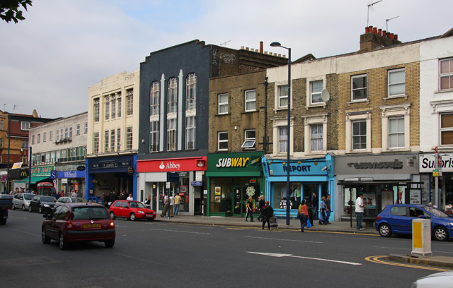
English: High Road, North Finchley Shops, building societies become banks and fast food, the story of many high streets around the country. The grey modern building on the extreme left was built on the site of Prior's department store. Prior's had moved to a new location at the junction of Castle Street and High Road. The two imposing buildings occupied by an O'Neills pub and Abbey Bank were respectively a furniture store JAC Woodhouse and Burtons the Tailor both built around 1936. The imposing tall windows at the front of what was Burtons was common to all Burton shops as they all had a billiard room above the shop - hence the need for good daylight! The rest of the parade of shops predate 1905. |
| תאריך יצירה | |
| מקור | From geograph.org.uk |
| יוצר | Martin Addison |
| ייחוס (required by the license) | Martin Addison / High Road, North Finchley / |
| מיקום המצלמה | | תמונה זו ותמונות נוספות במיקום: OpenStreetMap |
|---|
_heading:45.00&language=he)
| מיקום האובייקט | | תמונה זו ותמונות נוספות במיקום: OpenStreetMap |
|---|
_heading:45.00&language=he)
רישיון

|
This image was taken from the Geograph project collection. See this photograph's page on the Geograph website for the photographer's contact details. The copyright on this image is owned by Martin Addison and is licensed for reuse under the Creative Commons Attribution-ShareAlike 2.0 license.
|
הקובץ הזה מתפרסם לפי תנאי רישיון קריאייטיב קומונז ייחוס-שיתוף זהה 2.0 כללי.
ייחוס: Martin Addison
- הנכם רשאים:
- לשתף – להעתיק, להפיץ ולהעביר את העבודה
- לערבב בין עבודות – להתאים את העבודה
- תחת התנאים הבאים:
- ייחוס – יש לתת ייחוס הולם, לתת קישור לרישיון, ולציין אם נעשו שינויים. אפשר לעשות את זה בכל צורה סבירה, אבל לא בשום צורה שמשתמע ממנה שמעניק הרישיון תומך בך או בשימוש שלך.
- שיתוף זהה – אם תיצרו רמיקס, תשנו, או תבנו על החומר, חובה עליכם להפיץ את התרומות שלך לפי תנאי רישיון זהה או תואם למקור.
היסטוריית הקובץ
ניתן ללחוץ על תאריך/שעה כדי לראות את הקובץ כפי שנראה באותו זמן.
| תאריך/שעה | תמונה ממוזערת | ממדים | משתמש | הערה | |
|---|---|---|---|---|---|
| נוכחית | 13:06, 22 בפברואר 2011 | | 408 × 640 (140 ק"ב) | GeographBot | == {{int:filedesc}} == {{Information |description={{en|1=High Road, North Finchley Shops, building societies become banks and fast food, the story of many high streets around the country. The grey modern building on the extreme left was built on the site |
שימוש בקובץ
הדף הבא משתמש בקובץ הזה:
שימוש גלובלי בקובץ
אתרי הוויקי השונים הבאים משתמשים בקובץ זה:
- שימוש באתר ga.wikipedia.org
- שימוש באתר ja.wikipedia.org
- שימוש באתר www.wikidata.org