
קובץ:Iceland invasion targets.png
אין גרסה ברזולוציה גבוהה יותר.
Iceland_invasion_targets.png (485 × 343 פיקסלים, גודל הקובץ: 44 ק"ב, סוג MIME: image/png)
| זהו קובץ שמקורו במיזם ויקישיתוף. תיאורו בדף תיאור הקובץ המקורי (בעברית) מוצג למטה. |
תקציר
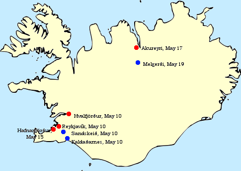
| תיאור | Initial British targets for the 1940 Invasion of Iceland: Reykjavík along with its harbour and seaplane landing site (Vatnagarðar), nearby landing grounds at Sandskeið and Kaldaðarnes to the east, the nearby anchorage at Hvalfjörður to the north, the harbour at Akureyri in the far north and the nearby landing grounds at Melgerði. The harbour at Hafnarfjörður, near Reykjavík, was also secured early on. | ||
| תאריך יצירה | |||
| מקור | Originally created and uploaded by Haukurth | ||
| יוצר | Originally created and uploaded by Haukurth | ||
| אישורים והיתרים (שימוש חוזר בקובץ זה) |
|
||
| גרסאות אחרות | File:Invasion of Iceland ja.svg |
היסטוריית הקובץ
ניתן ללחוץ על תאריך/שעה כדי לראות את הקובץ כפי שנראה באותו זמן.
| תאריך/שעה | תמונה ממוזערת | ממדים | משתמש | הערה | |
|---|---|---|---|---|---|
| נוכחית | 01:23, 17 ביוני 2023 | | 343 × 485 (44 ק"ב) | Hohum | Cartographic colours |
| 00:01, 12 ביוני 2008 |  | 343 × 485 (34 ק"ב) | Jágrmeister | {{Information |Description=Initial British targets for the 1940 Invasion of Iceland: Reykjavík along with its harbour and seaplane landing site (Vatnagarðar), nearby landing grounds at Sandskeið and Kaldaðarnes to the east, the nearby anchorage at Hva |
שימוש בקובץ
הדף הבא משתמש בקובץ הזה:
שימוש גלובלי בקובץ
אתרי הוויקי השונים הבאים משתמשים בקובץ זה:
- שימוש באתר ar.wikipedia.org
- שימוש באתר bg.wikipedia.org
- שימוש באתר da.wikipedia.org
- שימוש באתר de.wikipedia.org
- שימוש באתר el.wikipedia.org
- שימוש באתר en.wikipedia.org
- שימוש באתר es.wikipedia.org
- שימוש באתר fi.wikipedia.org
- שימוש באתר fr.wikipedia.org
- שימוש באתר id.wikipedia.org
- שימוש באתר is.wikipedia.org
- שימוש באתר it.wikipedia.org
- שימוש באתר lv.wikipedia.org
- שימוש באתר nl.wikipedia.org
- שימוש באתר no.wikipedia.org
- שימוש באתר pl.wikipedia.org
- שימוש באתר pt.wikipedia.org
- שימוש באתר ru.wikipedia.org
- שימוש באתר sr.wikipedia.org
- שימוש באתר sv.wikipedia.org
- שימוש באתר ta.wikipedia.org
- שימוש באתר tr.wikipedia.org
- שימוש באתר uk.wikipedia.org
- שימוש באתר vi.wikipedia.org
- שימוש באתר www.wikidata.org
- שימוש באתר zh.wikipedia.org