
קובץ:Karte Haus Burgund 4 EN.png
גודל התצוגה המקדימה הזאת: 426 × 600 פיקסלים. רזולוציות אחרות: 170 × 240 פיקסלים | 341 × 480 פיקסלים | 545 × 768 פיקסלים | 727 × 1,024 פיקסלים | 2,500 × 3,521 פיקסלים.
לקובץ המקורי (2,500 × 3,521 פיקסלים, גודל הקובץ: 1.33 מ"ב, סוג MIME: image/png)
| זהו קובץ שמקורו במיזם ויקישיתוף. תיאורו בדף תיאור הקובץ המקורי (בעברית) מוצג למטה. |
| תיאור |
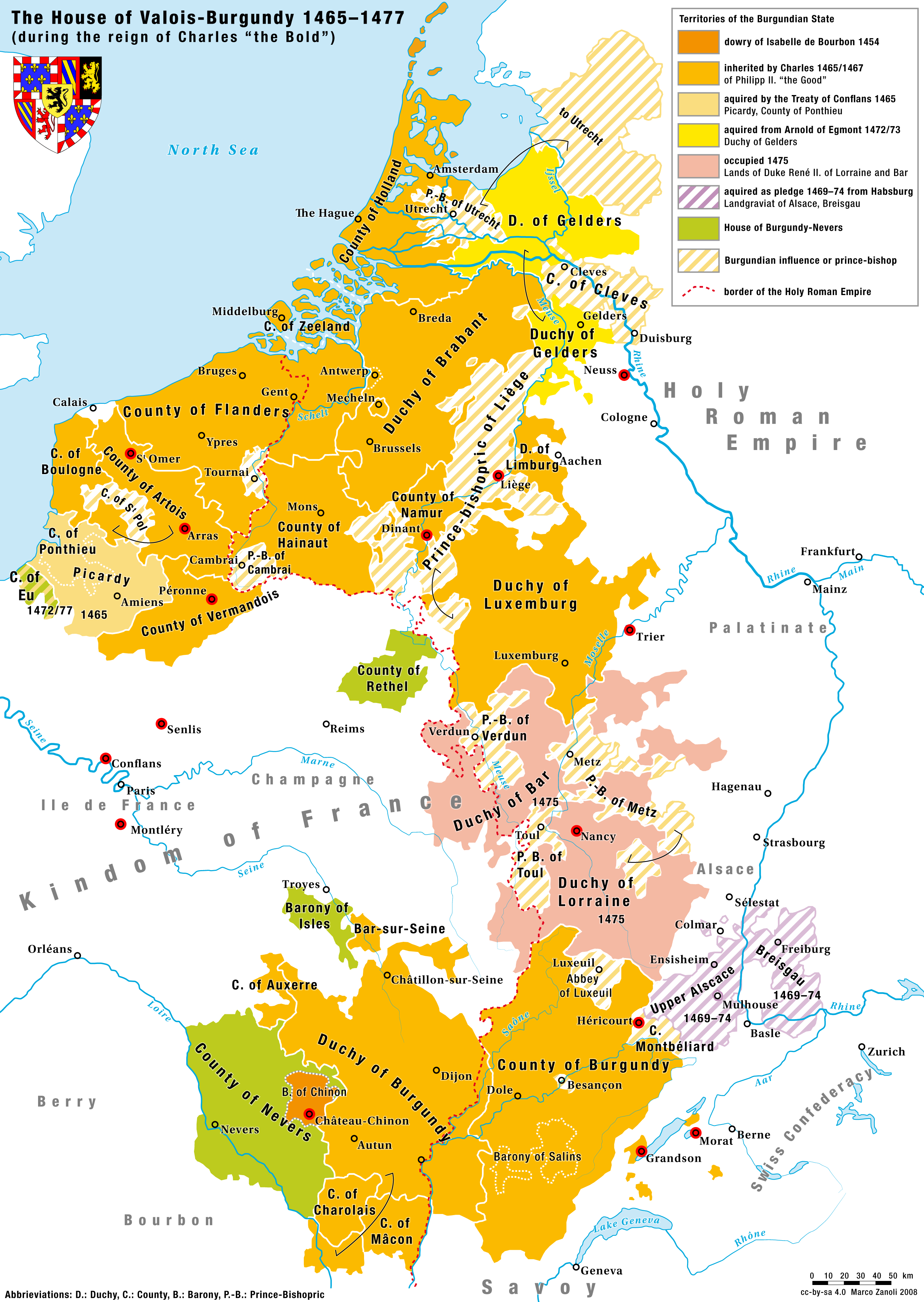
English: Territories of the House of Valois-Burgundy during the reign of Charles the Bold, 1465/67–1477 |
|
| תאריך יצירה | 2.5.2008 | |
| מקור | נוצר על־ידי מעלה היצירה | |
| יוצר | Marco Zanoli (sidonius 12:09, 2 May 2008 (UTC)) | |
| אישורים והיתרים (שימוש חוזר בקובץ זה) |
|
|
| גרסאות אחרות |
Coat of arms from: 
|


-ka.svg)

היסטוריית הקובץ
ניתן ללחוץ על תאריך/שעה כדי לראות את הקובץ כפי שנראה באותו זמן.
| תאריך/שעה | תמונה ממוזערת | ממדים | משתמש | הערה | |
|---|---|---|---|---|---|
| נוכחית | 19:10, 24 באוגוסט 2023 | | 3,521 × 2,500 (1.33 מ"ב) | Sidonius | corrected some mistakes and adapted to layout and design of German and French Version |
| 07:52, 4 ביולי 2010 |  | 1,690 × 1,200 (652 ק"ב) | DcoetzeeBot | Remove watermark, add author and license data to image metadata, decrease filesize with pngcrush | |
| 17:04, 17 ביוני 2008 |  | 1,690 × 1,200 (798 ק"ב) | Sidonius | small corrections, important cities and battles marked with red dot, county of cleves added etc. | |
| 15:09, 2 במאי 2008 |  | 1,787 × 1,200 (529 ק"ב) | Sidonius | {{Information |Description={{en|Territories of the House of Valois-Burgundy during the reign of Charles the Bold, 1465/67–1477}} |Source=own work |Date=2.5.2008 |Author=Marco Zanoli (~~~~) |Permission={{Attribution sidonius}} |other_versions=Coat of arm |
שימוש בקובץ
הדף הבא משתמש בקובץ הזה:
שימוש גלובלי בקובץ
אתרי הוויקי השונים הבאים משתמשים בקובץ זה:
- שימוש באתר ar.wikipedia.org
- שימוש באתר ast.wikipedia.org
- שימוש באתר azb.wikipedia.org
- שימוש באתר az.wikipedia.org
- שימוש באתר be.wikipedia.org
- שימוש באתר bg.wikipedia.org
- שימוש באתר ca.wikipedia.org
- שימוש באתר cs.wikipedia.org
- שימוש באתר de.wikipedia.org
- שימוש באתר el.wikipedia.org
- שימוש באתר en.wikipedia.org
- שימוש באתר eo.wikipedia.org
- שימוש באתר es.wikipedia.org
- שימוש באתר et.wikipedia.org
- שימוש באתר eu.wikipedia.org
- שימוש באתר fa.wikipedia.org
- שימוש באתר fi.wikipedia.org
- שימוש באתר fr.wikipedia.org
- שימוש באתר ga.wikipedia.org
- שימוש באתר gl.wikipedia.org
- שימוש באתר hr.wikipedia.org
- שימוש באתר hu.wikipedia.org