
קובץ:Kashmir Region (2020 skirmish locations).jpg
גודל התצוגה המקדימה הזאת: 604 × 599 פיקסלים. רזולוציות אחרות: 242 × 240 פיקסלים | 484 × 480 פיקסלים | 774 × 768 פיקסלים | 1,033 × 1,024 פיקסלים | 1,579 × 1,566 פיקסלים.
לקובץ המקורי (1,579 × 1,566 פיקסלים, גודל הקובץ: 1.27 מ"ב, סוג MIME: image/jpeg)
| זהו קובץ שמקורו במיזם ויקישיתוף. תיאורו בדף תיאור הקובץ המקורי (בעברית) מוצג למטה. |
.jpg)
.jpg?uselang=he)
תקציר
| תיאור |
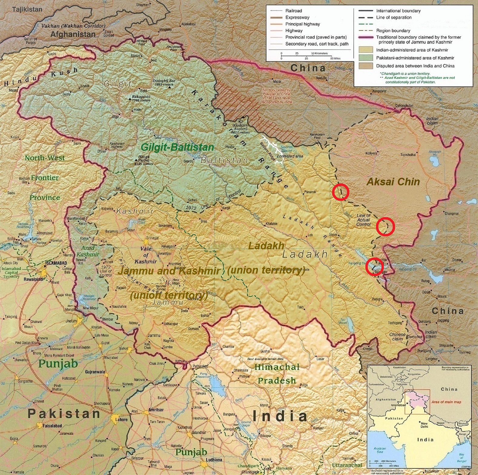
English: A map of the disputed Kashmir region created by the United States CIA in 2004 and hosted by the University of Texas at Austin Perry-Castañeda Library Map Collection; altered to show new jurisdictions by Fowler&fowler in November 2019; altered by to show 2020 skirmish locations by MarkH21 in June 2020. The red circles mark the rough locations of the conflicts at the the Galwan Valley (top), Hot Springs, Chang Chenmo Valley checkpoint (middle), and Pangong Tso (near the bottom). |
| תאריך יצירה | |
| מקור | Map of Kashmir region created by the US Central Intelligence Agency, 2004 |
| יוצר | United States Central Intelligence Agency |
| גרסאות אחרות |
  |
רישיון
This work is in the public domain in the United States because it is a work prepared by an officer or employee of the United States Government as part of that person’s official duties under the terms of Title 17, Chapter 1, Section 105 of the US Code.
Note: This only applies to original works of the Federal Government and not to the work of any individual U.S. state, territory, commonwealth, county, municipality, or any other subdivision. This template also does not apply to postage stamp designs published by the United States Postal Service since 1978. (See § 313.6(C)(1) of Compendium of U.S. Copyright Office Practices). It also does not apply to certain US coins; see The US Mint Terms of Use.
|
 | |
| הקובץ הזה זוהה כקובץ חופשי מכל מגבלה ידועה תחת חוק זכויות היוצרים, כולל כל הזכויות הקשורות והסמוכות. | ||
| Annotations | This image is annotated: View the annotations at Commons |
היסטוריית הקובץ
ניתן ללחוץ על תאריך/שעה כדי לראות את הקובץ כפי שנראה באותו זמן.
| תאריך/שעה | תמונה ממוזערת | ממדים | משתמש | הערה | |
|---|---|---|---|---|---|
| נוכחית | 21:45, 24 ביוני 2020 | | 1,566 × 1,579 (1.27 מ"ב) | MarkH21 | Removed the Daulat Beg Oldi circle as not being an actual location of conflict; added the Hot Springs, Chang Chenmo Valley circle as an actual location of conflict. |
| 05:01, 24 ביוני 2020 |  | 1,566 × 1,579 (1.27 מ"ב) | MarkH21 | Uploaded a work by United States Central Intelligence Agency, MarkH21 from [https://legacy.lib.utexas.edu/maps/middle_east_and_asia/kashmir_region_2004.jpg Map of Kashmir region] created by the US Central Intelligence Agency, 2004; altered by MarkH21 with UploadWizard |
שימוש בקובץ
הדף הבא משתמש בקובץ הזה:
שימוש גלובלי בקובץ
אתרי הוויקי השונים הבאים משתמשים בקובץ זה:
- שימוש באתר af.wikipedia.org
- שימוש באתר ca.wikipedia.org
- שימוש באתר en.wikipedia.org
- שימוש באתר es.wikipedia.org
- שימוש באתר fa.wikipedia.org
- שימוש באתר fr.wikipedia.org
- שימוש באתר ja.wikipedia.org
- שימוש באתר ka.wikipedia.org
- שימוש באתר ml.wikipedia.org
- שימוש באתר ne.wikipedia.org
- שימוש באתר pnb.wikipedia.org
- שימוש באתר pt.wikipedia.org
- שימוש באתר ru.wikipedia.org
- שימוש באתר simple.wikipedia.org
- שימוש באתר so.wikipedia.org
- שימוש באתר ta.wikipedia.org
- שימוש באתר te.wikipedia.org
- שימוש באתר th.wikipedia.org
- שימוש באתר tr.wikipedia.org
- שימוש באתר uk.wikipedia.org
- שימוש באתר ur.wikipedia.org
- שימוש באתר vi.wikipedia.org
- שימוש באתר www.wikidata.org
- שימוש באתר zh.wikipedia.org
.jpg)