
קובץ:Location-of-Liancourt-rocks-en.png
גודל התצוגה המקדימה הזאת: 800 × 400 פיקסלים. רזולוציות אחרות: 320 × 160 פיקסלים | 938 × 469 פיקסלים.
לקובץ המקורי (938 × 469 פיקסלים, גודל הקובץ: 286 ק"ב, סוג MIME: image/png)
| זהו קובץ שמקורו במיזם ויקישיתוף. תיאורו בדף תיאור הקובץ המקורי (בעברית) מוצג למטה. |

|
יש ליצור מחדש את התמונה locator map הזו באמצעות גרפיקה וקטורית כדוגמת קובץ SVG. לפעולה זו מספר יתרונות, כפי שניתן לקרוא (באנגלית) בדף Commons:Media for cleanup. אם ברשותכם קובץ SVG, אנא העלו אותו. לאחר מכן, החליפו תבנית זו בתבנית
{{vector version available|שם הקובץ.svg}} |
תקציר
| תיאור |
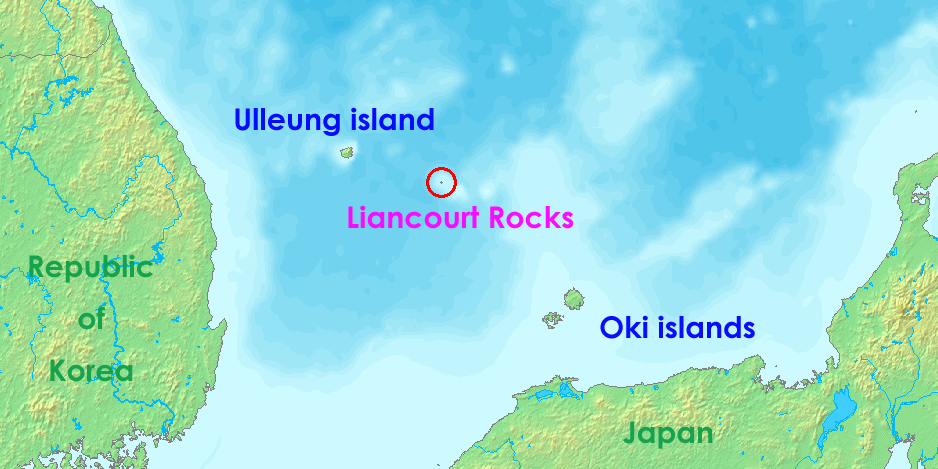
English: Liancourt rocks, in Japan called Takeshima and in North and South Korea called Dokdo (Tokto).
Ido: Liancourt roki, en Japonia nomata Takeshima ed en Nord e Sud-Korea nomata Dokto (Tokto). |
||||
| תאריך יצירה | 12 במאי 2006 (תאריך העלאה מקורי) | ||||
| מקור | http://www.demis.nl/wms/mapclip.htm | ||||
| יוצר | demis.nl | ||||
| אישורים והיתרים (שימוש חוזר בקובץ זה) |
|
היסטוריית הקובץ
ניתן ללחוץ על תאריך/שעה כדי לראות את הקובץ כפי שנראה באותו זמן.
| תאריך/שעה | תמונה ממוזערת | ממדים | משתמש | הערה | |
|---|---|---|---|---|---|
| נוכחית | 08:36, 17 ביולי 2008 | | 469 × 938 (286 ק"ב) | Ponta2 | Reverted to version as of 19:08, 6 April 2008 |
| 15:03, 16 ביולי 2008 |  | 400 × 800 (332 ק"ב) | 쿠도군 | ||
| 22:08, 6 באפריל 2008 |  | 469 × 938 (286 ק"ב) | Eurodollers | == Summary == {{Information |Description={{en|Location of Liancourt Rocks, where Korea and Japan claim that Liancourt rocks is their own territory.}} |Source= http://www.demis.nl/wms/mapclip.htm |Date= 12 May 2006 (original upload date) |Author= demis.nl | |
| 04:41, 5 ביוני 2007 |  | 320 × 640 (57 ק"ב) | Tene~commonswiki | Optimised (0;r) | |
| 12:43, 18 באוקטובר 2006 |  | 320 × 640 (60 ק"ב) | Conscious | Reverted to earlier revision | |
| 17:00, 12 במאי 2006 |  | 320 × 640 (60 ק"ב) | LERK | Location of Liancourt Rocks, where Korea and Japan claim that Liancourt rocks is their own territoriy. {{demis-pd}} Category:Maps of disputed territories Category:Maps of Korea Category:Islands of Korea Category:Maps of Japan [[Category:Is |
שימוש בקובץ
הדף הבא משתמש בקובץ הזה:
שימוש גלובלי בקובץ
אתרי הוויקי השונים הבאים משתמשים בקובץ זה:
- שימוש באתר af.wikipedia.org
- שימוש באתר ar.wikipedia.org
- שימוש באתר bat-smg.wikipedia.org
- שימוש באתר bh.wikipedia.org
- שימוש באתר ca.wikipedia.org
- שימוש באתר de.wikipedia.org
- שימוש באתר en.wikipedia.org
- שימוש באתר eo.wikipedia.org
- שימוש באתר es.wikipedia.org
- שימוש באתר fa.wikipedia.org
- שימוש באתר fi.wikipedia.org
- שימוש באתר fr.wikipedia.org
- שימוש באתר hi.wikipedia.org
- שימוש באתר id.wikipedia.org
- שימוש באתר it.wikipedia.org
- שימוש באתר ja.wikibooks.org
- שימוש באתר lt.wikipedia.org
- שימוש באתר ms.wikipedia.org
- שימוש באתר nl.wikipedia.org
- שימוש באתר no.wikipedia.org
- שימוש באתר pa.wikipedia.org
- שימוש באתר pl.wikipedia.org
- שימוש באתר pt.wikipedia.org
- שימוש באתר ro.wikipedia.org
- שימוש באתר simple.wikipedia.org