
קובץ:LuxembourgPartitionsMap english.jpg
אין גרסה ברזולוציה גבוהה יותר.
LuxembourgPartitionsMap_english.jpg (433 × 569 פיקסלים, גודל הקובץ: 46 ק"ב, סוג MIME: image/jpeg)
| זהו קובץ שמקורו במיזם ויקישיתוף. תיאורו בדף תיאור הקובץ המקורי (בעברית) מוצג למטה. |

|
קובץ זה הוחלף על ידי הקובץ File:LuxembourgPartitionsMap english.png. מומלץ להשתמש בקובץ החדש.
|

|
תקציר
| תיאור |
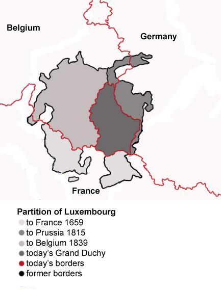
English: Map showing the partition of Luxembourg through the centuries.
Français : Carte montrant la partition du Luxembourg à travers les siècles, avec explications an anglais. |
| תאריך יצירה | |
| מקור |
|
| יוצר | Spanish_Inquisition |
| גרסאות אחרות |
|


רישיון
| ברצוני, בעלי זכויות היוצרים על יצירה זו, לשחרר יצירה זו לנחלת הכלל. זה תקף בכל העולם. יש מדינות שבהן הדבר אינו אפשרי על פי חוק, אם כך: אני מעניק לכל אחד את הזכות להשתמש בעבודה זו לכל מטרה שהיא, ללא תנאים כלשהם, אלא אם כן תנאים כאלה נדרשים על פי חוק. |
היסטוריית הקובץ
ניתן ללחוץ על תאריך/שעה כדי לראות את הקובץ כפי שנראה באותו זמן.
| תאריך/שעה | תמונה ממוזערת | ממדים | משתמש | הערה | |
|---|---|---|---|---|---|
| נוכחית | 21:11, 21 ביולי 2008 | | 569 × 433 (46 ק"ב) | Pretty Green~commonswiki | {{Information |Description= As previous, with rivers removed from map for clarity |Source= previous version |Date= 21 July 2008 |Author= Spanish Inquisition, modified by Pretty Green |Permission= |other_versions= }} |
| 17:58, 3 בספטמבר 2006 |  | 569 × 433 (82 ק"ב) | Spanish Inquisition | Map showing the partition of Luxembourg thorugh the centuries with english expanantions. Modification of the image LuxembourgPartitionsMap.png by user:QuartierLatin1968 14:10, 22 Apr 2005 (UTC). Author: user:Spanish_Inquisition Date: 3rd September 2006 |
שימוש בקובץ
הדף הבא משתמש בקובץ הזה:
שימוש גלובלי בקובץ
אתרי הוויקי השונים הבאים משתמשים בקובץ זה:
- שימוש באתר bg.wikipedia.org
- שימוש באתר en.wikipedia.org
- שימוש באתר it.wikipedia.org
- שימוש באתר ja.wikipedia.org
- שימוש באתר mn.wikipedia.org
- שימוש באתר no.wikipedia.org
- שימוש באתר th.wikipedia.org
- שימוש באתר vi.wikipedia.org