
קובץ:Macedonia topography-en.svg

לקובץ המקורי (קובץ SVG, הגודל המקורי: 920 × 652 פיקסלים, גודל הקובץ: 4.25 מ"ב)
| זהו קובץ שמקורו במיזם ויקישיתוף. תיאורו בדף תיאור הקובץ המקורי (בעברית) מוצג למטה. |
תקציר
| תיאור |
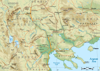
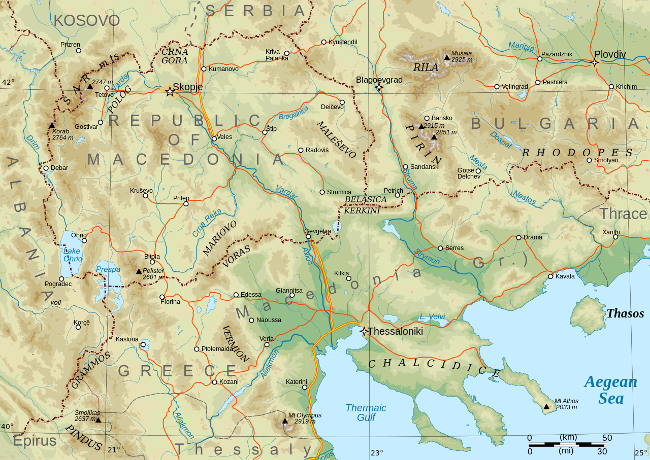
English: Topographical map of Macedonia, i.e. the Republic of North Macedonia, the Greek province of Macedonia, and southwestern Bulgaria. |
| תאריך יצירה | |
| מקור | נוצר על־ידי מעלה היצירה |
| יוצר | Future Perfect at Sunrise |
| גרסאות אחרות |
Derivative works of this file: Macedonia topography-He.svg This file version has non-horizontal text labels converted to paths, to ensure correct display with renderers that don't do advanced text layout along paths. If you want to modify or translate this map, please work on the basis of File:Macedonia topography (texts).svg, which has the labels preserved as texts (but will only display correctly in Inkscape).
|

.svg)
Made with GRASS GIS and Inkscape software from public-domain geo data (SRTM3, SWBD, VMAP0). See the excellent tutorials by User:Sting at w:fr:Wikipédia:Atelier graphique/Didacticiels cartographiques/Didacticiels pour la cartographie numérique géoréférencée. Relief levels vectorised and exported to SVG; relief shading is embedded bitmap graphics.
Geographical extent: c. 20.5E to 25.3E, 39.8N to 42.4N; map projection: Lambert conformal conic with standard parallels 40 and 42N, standard meridian 23E. Scale approx. 1:1,600,000 at nominal SVG size.
רישיון
| ברצוני, בעלי זכויות היוצרים על יצירה זו, לשחרר יצירה זו לנחלת הכלל. זה תקף בכל העולם. יש מדינות שבהן הדבר אינו אפשרי על פי חוק, אם כך: אני מעניק לכל אחד את הזכות להשתמש בעבודה זו לכל מטרה שהיא, ללא תנאים כלשהם, אלא אם כן תנאים כאלה נדרשים על פי חוק. |
היסטוריית הקובץ
ניתן ללחוץ על תאריך/שעה כדי לראות את הקובץ כפי שנראה באותו זמן.
| תאריך/שעה | תמונה ממוזערת | ממדים | משתמש | הערה | |
|---|---|---|---|---|---|
| נוכחית | 11:29, 31 בינואר 2009 | | 652 × 920 (4.25 מ"ב) | Future Perfect at Sunrise | some additions and corrections |
| 00:49, 24 בינואר 2009 |  | 652 × 920 (4.01 מ"ב) | Future Perfect at Sunrise | {{Information |Description={{en|1=Topographical map of geographic Macedonia}} |Source=Own work by uploader |Author=Future Perfect at Sunrise |Date=23 January 2009 |Permission= |other_versions= }} <!--{{ImageUpload|full} |
שימוש בקובץ
הדף הבא משתמש בקובץ הזה:
שימוש גלובלי בקובץ
אתרי הוויקי השונים הבאים משתמשים בקובץ זה:
- שימוש באתר ang.wikipedia.org
- שימוש באתר ar.wikipedia.org
- שימוש באתר ca.wikipedia.org
- שימוש באתר el.wikipedia.org
- שימוש באתר en.wikipedia.org
- שימוש באתר fa.wikipedia.org
- שימוש באתר fi.wikipedia.org
- שימוש באתר fr.wikipedia.org
- שימוש באתר id.wikipedia.org
- שימוש באתר it.wikipedia.org
- שימוש באתר ja.wikipedia.org
- שימוש באתר ms.wikipedia.org
- שימוש באתר pl.wikipedia.org
- שימוש באתר sq.wikipedia.org
- שימוש באתר sr.wikipedia.org
- שימוש באתר sw.wikipedia.org
- שימוש באתר trv.wikipedia.org
- שימוש באתר war.wikipedia.org
- שימוש באתר zh-yue.wikipedia.org
- שימוש באתר zh.wikipedia.org