
קובץ:Map of the Original City of Philadelphia in 1682 by Thomas Holme.jpg

גודל התצוגה המקדימה הזאת: 800 × 565 פיקסלים. רזולוציות אחרות: 320 × 226 פיקסלים | 640 × 452 פיקסלים | 1,024 × 723 פיקסלים | 1,280 × 903 פיקסלים | 2,560 × 1,806 פיקסלים | 5,330 × 3,761 פיקסלים.
לקובץ המקורי (5,330 × 3,761 פיקסלים, גודל הקובץ: 10.26 מ"ב, סוג MIME: image/jpeg)
| זהו קובץ שמקורו במיזם ויקישיתוף. תיאורו בדף תיאור הקובץ המקורי (בעברית) מוצג למטה. |
תקציר
| תיאור |
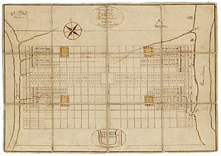
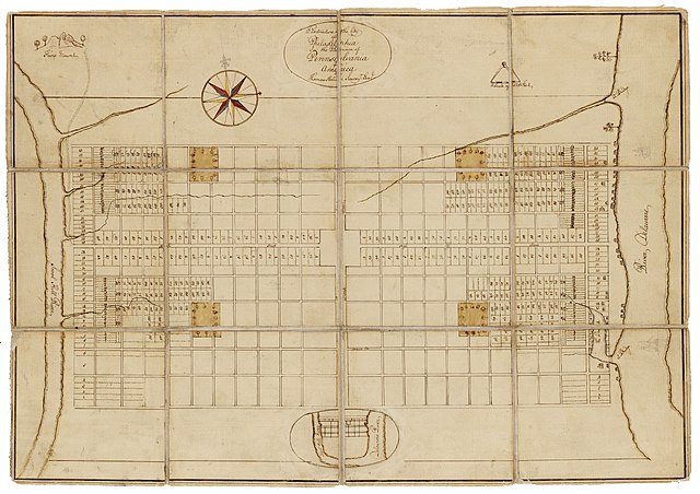
English: Holme, Thomas (1683). A Portraiture of the City of Philadelphia (map): In the province of Pennsylvania in America. London: Sold by Andrew Sowle in Shoreditch. In 1682, William Penn appointed Holme surveyor-general of Pennsylvania and charged him with the task of laying out the "greene country towne" that Penn envisioned along the Delaware River. The site that Penn acquired for the city of Philadelphia stretched two miles east to west across a tract of land situated between the Delaware and Schuylkill Rivers; all told, the rectangular grid of land comprised twelve thousand acres. Holme imposed an orderly grid plan on the site, with streets organized around a large square in the center of the town and four smaller squares, one in each quadrant. The grid also included two main streets, Broad and High (present-day Market), which were kept wide in hopes of preventing the kind of fire that destroyed London in 1666. Completed in 1683, this map was used for both reference and promotional purposes to show the unique layout of William's Penn emerging city. From the Historical Society of Pennsylvania: https://hsp.org/education/primary-sources/a-map-of-the-original-city-of-philadelphia |
| תאריך יצירה | |
| מקור | https://hsp.org/education/primary-sources/a-map-of-the-original-city-of-philadelphia |
| יוצר | Thomas Holme |
רישיון
This work is in the public domain in the United States because it was published (or registered with the U.S. Copyright Office) before January 1, 1929.
Public domain works must be out of copyright in both the United States and in the source country of the work in order to be hosted on the Commons. If the work is not a U.S. work, the file must have an additional copyright tag indicating the copyright status in the source country.
Note: This tag should not be used for sound recordings. |
היסטוריית הקובץ
ניתן ללחוץ על תאריך/שעה כדי לראות את הקובץ כפי שנראה באותו זמן.
| תאריך/שעה | תמונה ממוזערת | ממדים | משתמש | הערה | |
|---|---|---|---|---|---|
| נוכחית | 23:57, 23 בינואר 2020 | | 3,761 × 5,330 (10.26 מ"ב) | N-gio | Sharpened focus, color, and contrast |
| 21:37, 23 בינואר 2020 |  | 3,761 × 5,330 (1.9 מ"ב) | N-gio | User created page with UploadWizard |
שימוש בקובץ
הדף הבא משתמש בקובץ הזה:
שימוש גלובלי בקובץ
אתרי הוויקי השונים הבאים משתמשים בקובץ זה:
- שימוש באתר en.wikipedia.org
- שימוש באתר tr.wikipedia.org