
קובץ:Map of the Territory of the Iceni.svg

גודל התצוגה המקדימה הזאת מסוג PNG של קובץ ה־SVG הזה: 424 × 600 פיקסלים. רזולוציות אחרות: 170 × 240 פיקסלים | 339 × 480 פיקסלים | 543 × 768 פיקסלים | 724 × 1,024 פיקסלים | 1,448 × 2,048 פיקסלים | 744 × 1,052 פיקסלים.
לקובץ המקורי (קובץ SVG, הגודל המקורי: 744 × 1,052 פיקסלים, גודל הקובץ: 151 ק"ב)
| זהו קובץ שמקורו במיזם ויקישיתוף. תיאורו בדף תיאור הקובץ המקורי (בעברית) מוצג למטה. |
| תיאור |
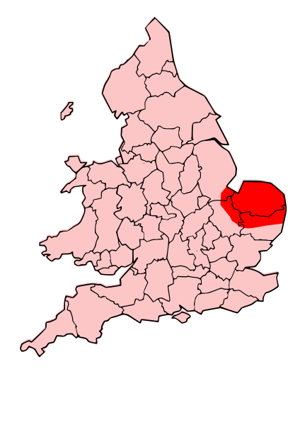
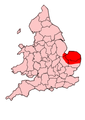
English: A map showing the territory of the Iceni tribe overlayed in red in the context of the modern county boundaries of England and wales |
| תאריך יצירה | (UTC) |
| מקור | |
| יוצר |
|
.svg)
.png)
| זוהי תמונה מרוטשת, זאת אומרת שהתמונה שונתה בצורה דיגיטלית מהמקור. Modifications: Revised to show extent of Iceni Territory. את התמונה המקורית ניתן לראות ב: Map of the Territory of the Dobunni.svg. השינוי בוצע על ידי Jpb1301.
|
הקובץ הזה מתפרסם לפי תנאי רישיון קריאייטיב קומונז ייחוס-שיתוף זהה 3.0 לא מותאם.
- הנכם רשאים:
- לשתף – להעתיק, להפיץ ולהעביר את העבודה
- לערבב בין עבודות – להתאים את העבודה
- תחת התנאים הבאים:
- ייחוס – יש לתת ייחוס הולם, לתת קישור לרישיון, ולציין אם נעשו שינויים. אפשר לעשות את זה בכל צורה סבירה, אבל לא בשום צורה שמשתמע ממנה שמעניק הרישיון תומך בך או בשימוש שלך.
- שיתוף זהה – אם תיצרו רמיקס, תשנו, או תבנו על החומר, חובה עליכם להפיץ את התרומות שלך לפי תנאי רישיון זהה או תואם למקור.
יומן העלאה מקורי
This image is a derivative work of the following images:
- File:England_Celtic_tribes_-_South.png licensed with Cc-by-sa-3.0-migrated, GFDL
- 2007-11-16T12:21:48Z File Upload Bot (Magnus Manske) 550x297 (105767 Bytes) {{BotMoveToCommons|en.wikipedia}} {{Information |Description={{en|Image depicting the Celts of South England, pre-[[:en:Roman Britain]] times. I created this myself, under the guidence (to find location of them) of [http://w
- File:Map_of_the_Territory_of_the_Dobunni.svg licensed with Cc-by-sa-3.0, GFDL
- 2009-10-13T19:47:34Z Jpb1301 744x1052 (151192 Bytes) {{Information |Description={{en|1=A map showing the territory of the Dobunni tribe overlayed in red in the context of the modern county boundaries of England and wales}} |Source=*[[:File:Map_of_the_Territory_of_the_Dobunni.sv
- 2009-10-13T17:38:36Z Jpb1301 744x1052 (151194 Bytes) {{Information |Description={{en|1=A map showing the territory of the Dobunni tribe overlayed in red in the context of the modern county boundaries of England and wales}} |Source=*[[:File:Map_of_the_Territory_of_the_Cornovii_(
Uploaded with derivativeFX
היסטוריית הקובץ
ניתן ללחוץ על תאריך/שעה כדי לראות את הקובץ כפי שנראה באותו זמן.
| תאריך/שעה | תמונה ממוזערת | ממדים | משתמש | הערה | |
|---|---|---|---|---|---|
| נוכחית | 22:30, 24 באוקטובר 2009 | | 1,052 × 744 (151 ק"ב) | Jpb1301 | {{Information |Description={{en|1=A map showing the territory of the Iceni tribe overlayed in red in the context of the modern county boundaries of England and wales}} |Source=*File:England_Celtic_tribes_-_South.png *[[:File:Map_of_the_Territory_of_ |
שימוש בקובץ
הדף הבא משתמש בקובץ הזה:
שימוש גלובלי בקובץ
אתרי הוויקי השונים הבאים משתמשים בקובץ זה:
- שימוש באתר ar.wikipedia.org
- שימוש באתר bg.wikipedia.org
- שימוש באתר br.wikipedia.org
- שימוש באתר ca.wikipedia.org
- שימוש באתר da.wikipedia.org
- שימוש באתר en.wikipedia.org
- שימוש באתר es.wikipedia.org
- שימוש באתר fa.wikipedia.org
- שימוש באתר fi.wikipedia.org
- שימוש באתר hr.wikipedia.org
- שימוש באתר hy.wikipedia.org
- שימוש באתר id.wikipedia.org
- שימוש באתר it.wikipedia.org
- שימוש באתר ja.wikipedia.org
- שימוש באתר la.wikipedia.org
- שימוש באתר nl.wikipedia.org
- שימוש באתר no.wikipedia.org
- שימוש באתר pl.wikipedia.org
- שימוש באתר pt.wikipedia.org
- שימוש באתר ro.wikipedia.org
- שימוש באתר ru.wikipedia.org
- שימוש באתר si.wikipedia.org
- שימוש באתר sv.wikipedia.org
- שימוש באתר uk.wikipedia.org
- שימוש באתר ur.wikipedia.org