
קובץ:Mississippi Delta Lobes.jpg
אין גרסה ברזולוציה גבוהה יותר.
Mississippi_Delta_Lobes.jpg (800 × 484 פיקסלים, גודל הקובץ: 73 ק"ב, סוג MIME: image/jpeg)
| זהו קובץ שמקורו במיזם ויקישיתוף. תיאורו בדף תיאור הקובץ המקורי (בעברית) מוצג למטה. |
From : http://en.wikipedia.org/wiki/Image:Mississippi_Delta_Lobes.jpg
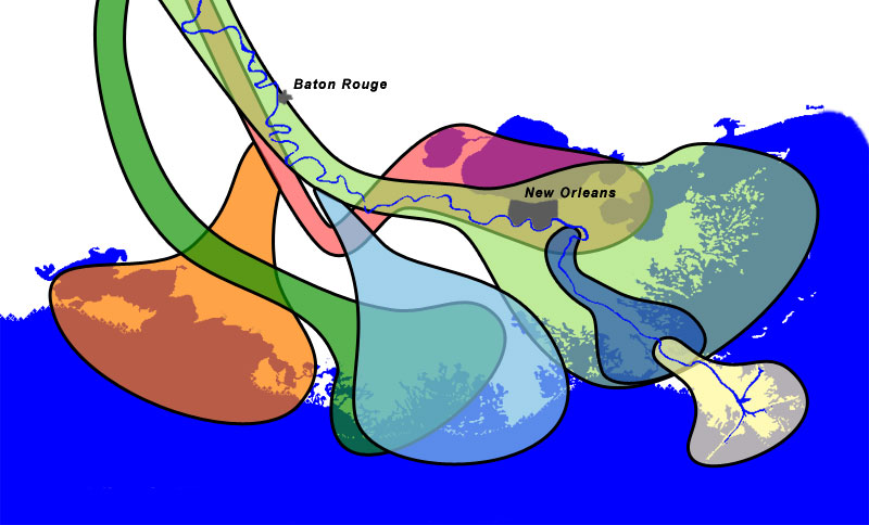
| Salé-Cypremort | 4600 years BP | |
| Cocodrie | 4600–3500 years BP | |
| Teche | 3500–2800 years BP | |
| St. Bernard | 2800–1000 years BP | |
| Lafourche | 1000–300 years BP | |
| Plaquemine | 750–500 years BP | |
| Balize | 550 years |
תקציר
The lobes of the Mississippi River Delta that formed over thousands of years due to deltaic switching.


Sources
- Wicander,Monroe (1993) Historical Geology - Evolution of Earth and Life through Time, West Publishing Company ISBN 0314012400 [1]
- Kolb,van Lopik (1958) Geology of the Mississippi River deltaic plain, southeastern Louisiana. Technical Report 3-483, Vicksburg, MS: U.S. Army Corps of Engineers Waterways Experiment Station (PDF, 6.86MB) [2]
- Delta Complexes of Mississippi River Deltaic Plain, Frazier, 1967 [3]
רישיון
| ברצוני, בעלי זכויות היוצרים על יצירה זו, לשחרר יצירה זו לנחלת הכלל. זה תקף בכל העולם. יש מדינות שבהן הדבר אינו אפשרי על פי חוק, אם כך: אני מעניק לכל אחד את הזכות להשתמש בעבודה זו לכל מטרה שהיא, ללא תנאים כלשהם, אלא אם כן תנאים כאלה נדרשים על פי חוק. |
Coast and river images from the National Map Server. Lobe outlines originally traced directly from Wicander and Monroe, 1993, but the shorline and river didn't match the USGS data, so the outlines had to be reinterpretted slightly.
Final Photoshop layers can be found here, in case updates are needed.
היסטוריית הקובץ
ניתן ללחוץ על תאריך/שעה כדי לראות את הקובץ כפי שנראה באותו זמן.
| תאריך/שעה | תמונה ממוזערת | ממדים | משתמש | הערה | |
|---|---|---|---|---|---|
| נוכחית | 15:51, 30 בדצמבר 2006 | | 484 × 800 (73 ק"ב) | Urban~commonswiki | From : http://en.wikipedia.org/wiki/Image:Mississippi_Delta_Lobes.jpg {| |<div class="key" style="background-color:#FFA447; width:1.5em; height:1.5em; border: 2px solid black"> </div> |Salé-Cypremort |4600 years [ |
שימוש בקובץ
הדפים הבאים משתמשים בקובץ הזה:
שימוש גלובלי בקובץ
אתרי הוויקי השונים הבאים משתמשים בקובץ זה:
- שימוש באתר ar.wikipedia.org
- שימוש באתר de.wikipedia.org
- שימוש באתר en.wikipedia.org
- שימוש באתר en.wikiversity.org
- שימוש באתר et.wikipedia.org
- שימוש באתר fr.wikipedia.org
- שימוש באתר hu.wikipedia.org
- שימוש באתר pt.wikipedia.org
- שימוש באתר sl.wikipedia.org
- שימוש באתר tr.wikipedia.org
- שימוש באתר ur.wikipedia.org
- שימוש באתר zh.wikipedia.org