קובץ:Mjo north america rain.png

תוכן הדף אינו נתמך בשפות אחרות.
מתוך ויקיפדיה, האנציקלופדיה החופשית

לקובץ המקורי(556 × 749 פיקסלים, גודל הקובץ: 28 ק"ב, סוג MIME‏: image/png)

ויקישיתוף זהו קובץ שמקורו במיזם ויקישיתוף. תיאורו בדף תיאור הקובץ המקורי (בעברית) מוצג למטה.
תיאור
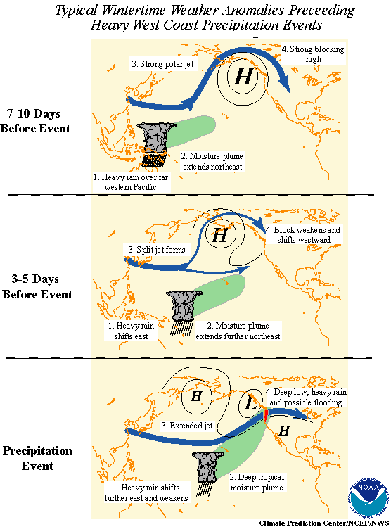
English: Madden-Julian oscillation effects upon North American weather patterns. Eastward-moving tropical rainfall circulation drives north Pacific Ocean atmospheric circulation changes.

Here are the 3 progressive steps:

  • 7-10 days prior to the heavy precipitation event, heavy tropical rainfall associated with the MJO shifts eastward from the eastern Indian Ocean to the western tropical Pacific. A moisture plume extends northeastward from the western tropical Pacific towards the general vicinity of the Hawaiian Islands. A strong blocking anticyclone is located in the Gulf of Alaska with a strong polar jet stream around its northern flank.
  • 3-5 days prior to the heavy precipitation event, heavy tropical rainfall shifts eastward towards the date line and begins to diminish. The associated moisture plume extends further to the northeast, often traversing the Hawaiian Islands. The strong blocking high weakens and shifts westward. A split in the North Pacific jet stream develops, characterized by an increase in the amplitude and areal extent of the upper tropospheric westerly zonal winds on the southern flank of the block and a decrease on its northern flank. The tropical and extratropical circulation patterns begin to "phase", allowing a developing midlatitude trough to tap the moisture plume extending from the deep tropics.
  • As the pattern of enhanced tropical rainfall continues to shift further to the east and weaken, the deep tropical moisture plume extends from the subtropical central Pacific into the midlatitude trough now located off the west coast of North America. The jet stream at upper levels extends across the North Pacific with the mean jet position entering North America in the northwestern United States. Deep low pressure located near the Pacific Northwest coast can bring up to several days of heavy rain and possible flooding. These events are often referred to as "pineapple express" events, so named because a significant amount of the deep tropical moisture traverses the Hawaiian Islands on its way towards western North America.
תאריך יצירה
מקור NOAA in article Monitoring Interseasonal Oscillations
יוצר Pierre_cb
אישורים והיתרים
(שימוש חוזר בקובץ זה)
Public domain
This image is in the public domain because it contains materials that originally came from the U.S. National Oceanic and Atmospheric Administration, taken or made as part of an employee's official duties.

العربية  čeština  Deutsch  Zazaki  English  español  eesti  suomi  français  hrvatski  magyar  italiano  日本語  한국어  македонски  മലയാളം  Plattdüütsch  Nederlands  polski  português  română  русский  sicilianu  slovenščina  Türkçe  Tiếng Việt  简体中文  繁體中文  +/−

גרסאות אחרות French in File:Mjo north america rain f.png.
יש ליצור מחדש את התמונה הזו באמצעות גרפיקה וקטורית כדוגמת קובץ SVG. לפעולה זו מספר יתרונות, כפי שניתן לקרוא (באנגלית) בדף Commons:Media for cleanup. אם ברשותכם קובץ SVG, אנא העלו אותו. לאחר מכן, החליפו תבנית זו בתבנית
{{vector version available|שם הקובץ.svg}}

היסטוריית הקובץ

ניתן ללחוץ על תאריך/שעה כדי לראות את הקובץ כפי שנראה באותו זמן.

תאריך/שעהתמונה ממוזערתממדיםמשתמשהערה
נוכחית19:01, 25 באוגוסט 2010תמונה ממוזערת לגרסה מ־19:01, 25 באוגוסט 2010‪749 × 556‬ (28 ק"ב)Pierre cbEnglish version
04:35, 24 בדצמבר 2006תמונה ממוזערת לגרסה מ־04:35, 24 בדצמבר 2006‪667 × 557‬ (50 ק"ב)Pierre cb{{Information |Description=Madden-Julian oscillation effects upon North American weather patterns. Eastward-moving tropical rainfall circulation drives north Pacific Ocean atmospheric circulation changes. |Source= [http://www.cpc.ncep.noaa.gov/p

הדף הבא משתמש בקובץ הזה:

שימוש גלובלי בקובץ

אתרי הוויקי השונים הבאים משתמשים בקובץ זה: