
קובץ:Mozambique relief location map.jpg

גודל התצוגה המקדימה הזאת: 398 × 599 פיקסלים. רזולוציות אחרות: 159 × 240 פיקסלים | 319 × 480 פיקסלים | 510 × 768 פיקסלים | 680 × 1,024 פיקסלים | 1,329 × 2,000 פיקסלים.
לקובץ המקורי (1,329 × 2,000 פיקסלים, גודל הקובץ: 1.23 מ"ב, סוג MIME: image/jpeg)
| זהו קובץ שמקורו במיזם ויקישיתוף. תיאורו בדף תיאור הקובץ המקורי (בעברית) מוצג למטה. |
| תיאור |
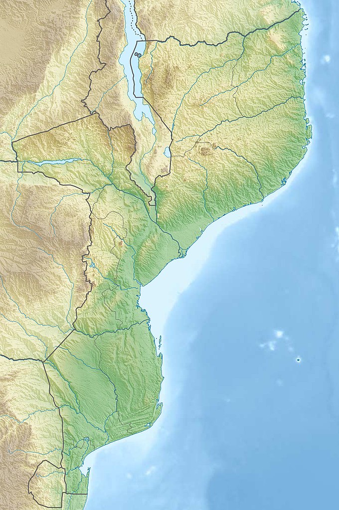
Deutsch: Physische Positionskarte von Mosambik
Quadratische Plattkarte, N-S-Streckung 105 %. Geographische Begrenzung der Karte:
English: Physical location map of Mozambique
Equirectangular projection, N/S stretching 105 %. Geographic limits of the map:
|
| תאריך יצירה | |
| מקור |
נוצר על־ידי מעלה היצירה, using
|
| יוצר | Carport |
| אישורים והיתרים (שימוש חוזר בקובץ זה) |
הקובץ הזה מתפרסם לפי תנאי רישיון קריאייטיב קומונז ייחוס-שיתוף זהה 3.0 לא מותאם.
|
| גרסאות אחרות |
|

היסטוריית הקובץ
ניתן ללחוץ על תאריך/שעה כדי לראות את הקובץ כפי שנראה באותו זמן.
| תאריך/שעה | תמונה ממוזערת | ממדים | משתמש | הערה | |
|---|---|---|---|---|---|
| נוכחית | 23:31, 3 במרץ 2020 | | 2,000 × 1,329 (1.23 מ"ב) | Sémhur | Adding Tanzanian border claim (from https://www.nbs.go.tz/index.php/en/census-surveys/gis/385-2012-phc-shapefiles-level-one-and-two) |
| 00:30, 16 בדצמבר 2012 |  | 2,000 × 1,329 (1.11 מ"ב) | Carport | {{Information |Description= {{de|Physische Positionskarte von Mosambik}} Quadratische Plattkarte, N-S-Streckung 105 %. Geographische Begrenzung der Karte: * N: 10.2° S * S: 27.4° S * W: 29.8° O * O: 41.8° O {{en|Location map of [[:... |
שימוש בקובץ
הדפים הבאים משתמשים בקובץ הזה:
שימוש גלובלי בקובץ
אתרי הוויקי השונים הבאים משתמשים בקובץ זה:
- שימוש באתר af.wikipedia.org
- שימוש באתר ar.wikipedia.org
- שימוש באתר az.wikipedia.org
- שימוש באתר ban.wikipedia.org
- שימוש באתר bg.wikipedia.org
- שימוש באתר bn.wikipedia.org
- שימוש באתר bs.wikipedia.org
- שימוש באתר ca.wikipedia.org
- שימוש באתר ceb.wikipedia.org
- שימוש באתר ce.wikipedia.org
- שימוש באתר da.wikipedia.org
- שימוש באתר de.wikipedia.org
- Mosambik
- Cahora-Bassa-Talsperre
- Ilha de Moçambique
- Monte Binga
- Bazaruto
- Maputo-Bucht
- Vorlage:Positionskarte Mosambik
- Monte Namuli
- Wikipedia:Kartenwerkstatt/Positionskarten/Afrika
- Quirimbas
- Inhaca
- Ibo (Insel)
- Monte Mabu
- Amaramba-See
- Angoche (Insel)
- Grande Hotel Beira
- Massingir-Talsperre
- Liste von Kraftwerken in Mosambik
- Benguerra
- Bucht von Tungue
- שימוש באתר de.wikivoyage.org
- שימוש באתר dsb.wikipedia.org