
קובץ:Operation Azul.jpg
גודל התצוגה המקדימה הזאת: 800 × 465 פיקסלים. רזולוציות אחרות: 320 × 186 פיקסלים | 640 × 372 פיקסלים | 1,024 × 595 פיקסלים | 1,280 × 744 פיקסלים | 2,040 × 1,185 פיקסלים.
לקובץ המקורי (2,040 × 1,185 פיקסלים, גודל הקובץ: 449 ק"ב, סוג MIME: image/jpeg)
| זהו קובץ שמקורו במיזם ויקישיתוף. תיאורו בדף תיאור הקובץ המקורי (בעברית) מוצג למטה. |
תקציר
Drawn by myself (Max Smith) in Visio.
Re-uploaded as JPG - big PNGs don't seem to work.
Released into the public domain, but a credit would be nice.
Based on a map in Martin Middlebrook's : The Fight For The Malvinas.
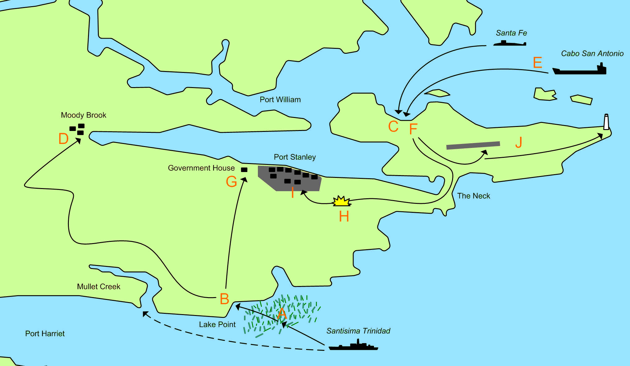
The map showing the area of the Falkland Islands around Port Stanley and the actions of 1 April 1982 and 2 April 1982 during the 1982 Invasion of the Falkland Islands.

|
קיימת תמונה חדשה תמונה זו בגרסה וקטורית בפורמט "SVG". יש להחליף את התמונה הנוכחית בתמונה החדשה.
File:Operation Azul.jpg → File:Operation Azul.svg
למידע נוסף אודות גרפיקה וקטורית, אנא קראו אודות המעבר של ויקישיתוף לתמונות בפורמט SVG. ראו גם מידע אודות התמידה של מדיה-ויקי בתמונות בפורמט SVG. |
 |
- A. 21:30 1 April - The Type 42 destroyerSantisima Trinidad begins loading marines of the Amphibious Commando Company into 21 small inflatable motor boats. These set out for Mullet Creek at but sail too far north and are caught up in beds of Kelp, which cause problems for the boats. They decide to head for the nearest beach, which is near Lake Point.
- B. 23:00 1 April - The first group of 91 men lands on an unamed beach at Lake Point. The group splits into a smaller force commanded by Lieutenant-Commander Giachino who head towards Government House, and a larger force commanded by Lieutenant-Commander Sabarots who head towards Moody Brook Barracks.
- C. 04:30 2 April - A small advanced group from Buzos Tacticos is landed from the Submarine Santa Fe.
- D. 05:30 2 April - Lieutenant-Commander Sabarots force reaches and surrounds the Barracks. They throw tear gas grenades into the buildings and fire machine gun tracer over the buildings. They find the buildings are deserted.
- E. 06:00 2 April - 20 FMC Amtracs and several LARC 5 stores carrying vehicles are launched from Caba San Antionio. The force splits into 3 groups:
- A four Amtrac vanguard. Including one carrying the Army Platoon.
- The main force of 14 Amtracs.
- The second in command, a recovery Amtrac and LARC vehciles.
- F. 06:30 2 April - The first Amtracs land and meet no resistance. The Army platoon captures the deserted airport.
- G. 06:30 2 April - The 5 man Argentine force reaches government house, where they are stopped by 31 Royal Marines, 11 armed Royal Navy men and 1 locals. Two Argentines are wounded (one would later die), and the remaining 3 are captured.
- H. 07:15 2 April - Having met no resistance, the Argentine Amtracs advance on Stanley, when they are ambushed from a house about 500 meters from the road. Royal Marines use rockets and machine gun fire. The Royal Marines fall back to government house. One of the Amtracs is scarred by machine gun fire, and there is one minor injury.
- I. 08:00 2 April - The Argentine Amtrac force secures Port Stanley.
- J. The Army platoon begins clearing the runway and seizes the light house.
רישיון
| ברצוני, בעלי זכויות היוצרים על יצירה זו, לשחרר יצירה זו לנחלת הכלל. זה תקף בכל העולם. יש מדינות שבהן הדבר אינו אפשרי על פי חוק, אם כך: אני מעניק לכל אחד את הזכות להשתמש בעבודה זו לכל מטרה שהיא, ללא תנאים כלשהם, אלא אם כן תנאים כאלה נדרשים על פי חוק. |
היסטוריית הקובץ
ניתן ללחוץ על תאריך/שעה כדי לראות את הקובץ כפי שנראה באותו זמן.
| תאריך/שעה | תמונה ממוזערת | ממדים | משתמש | הערה | |
|---|---|---|---|---|---|
| נוכחית | 01:27, 11 במרץ 2011 | | 1,185 × 2,040 (449 ק"ב) | Megapixie | Fix colors. |
| 14:54, 26 בנובמבר 2006 |  | 1,185 × 2,040 (159 ק"ב) | Electionworld | == Summary == Drawn by myself (Max Smith) in Visio. Re-uploaded as JPG - big PNGs don't seem to work. Released into the public domain, but a credit would be ''nice''. Based on a map in Martin Middlebrook's : ''The Fight For The Malvinas''. The map sho |
שימוש בקובץ
הדף הבא משתמש בקובץ הזה:
שימוש גלובלי בקובץ
אתרי הוויקי השונים הבאים משתמשים בקובץ זה:
- שימוש באתר ar.wikipedia.org
- שימוש באתר ceb.wikipedia.org
- שימוש באתר en.wikipedia.org
- שימוש באתר es.wikipedia.org
- שימוש באתר fi.wikipedia.org
- שימוש באתר fr.wikipedia.org
- שימוש באתר hu.wikipedia.org
- שימוש באתר ja.wikipedia.org
- שימוש באתר no.wikipedia.org
- שימוש באתר pl.wikipedia.org
- שימוש באתר ru.wikipedia.org
- שימוש באתר sl.wikipedia.org
- שימוש באתר www.wikidata.org