
קובץ:Red Zone Map-fr.svg

גודל התצוגה המקדימה הזאת מסוג PNG של קובץ ה־SVG הזה: 800 × 537 פיקסלים. רזולוציות אחרות: 320 × 215 פיקסלים | 640 × 429 פיקסלים | 1,024 × 687 פיקסלים | 1,280 × 858 פיקסלים | 2,560 × 1,717 פיקסלים | 1,421 × 953 פיקסלים.
לקובץ המקורי (קובץ SVG, הגודל המקורי: 1,421 × 953 פיקסלים, גודל הקובץ: 443 ק"ב)
| זהו קובץ שמקורו במיזם ויקישיתוף. תיאורו בדף תיאור הקובץ המקורי (בעברית) מוצג למטה. |
| תיאור |
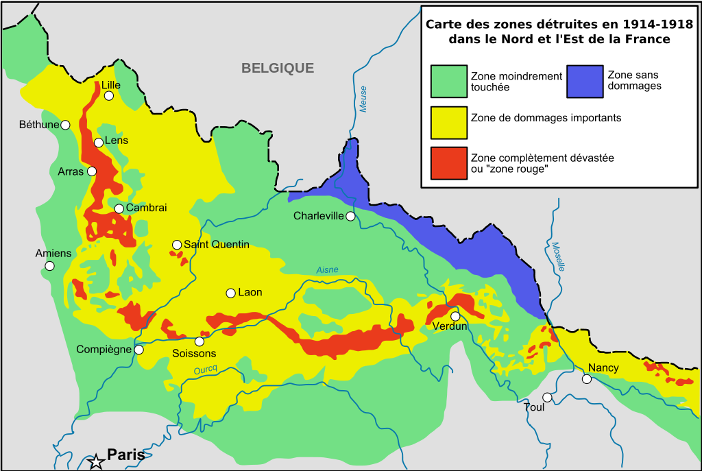
English: Zone rouge Map, describing in red zones completly destroyed by first world war / See also (french) [:http://fr.wikipedia.org/wiki/Zone_rouge_%28s%C3%A9quelles_de_guerre%29 French page of Wikipedia about red zone] La petite carte présente les bassins hydrographiques européens les plus concernés. Cette carte ne vaut que pour la France, mais la Belgique a également été très touchée (d'après Guicherd, J., & Matriot, C. (1921). La terre des régions dévastées'. Journal d'Agriculture Pratique, 34, 154-6.). Français : Cartographie des zones bleues, rouges et jaunes telles que décidées ou négociées après la fin de la Première Guerre mondiale (d'après Guicherd, J., & Matriot, C. (1921). La terre des régions dévastées'. Journal d'Agriculture Pratique, 34, 154-6.). |
| תאריך יצירה | (UTC) |
| מקור | |
| יוצר |
|
| גרסאות אחרות | Derivative works of this file: Red Zone Map-de.svg |
| זוהי תמונה מרוטשת, זאת אומרת שהתמונה שונתה בצורה דיגיטלית מהמקור. את התמונה המקורית ניתן לראות ב: Zone rougeRed Zone Map.jpg.
|
אני, בעל זכויות היוצרים על עבודה זו, מפרסם בזאת את העבודה תחת הרישיון הבא:
הקובץ הזה מתפרסם לפי תנאי רישיון קריאייטיב קומונז ייחוס-שיתוף זהה 2.5 כללי.
- הנכם רשאים:
- לשתף – להעתיק, להפיץ ולהעביר את העבודה
- לערבב בין עבודות – להתאים את העבודה
- תחת התנאים הבאים:
- ייחוס – יש לתת ייחוס הולם, לתת קישור לרישיון, ולציין אם נעשו שינויים. אפשר לעשות את זה בכל צורה סבירה, אבל לא בשום צורה שמשתמע ממנה שמעניק הרישיון תומך בך או בשימוש שלך.
- שיתוף זהה – אם תיצרו רמיקס, תשנו, או תבנו על החומר, חובה עליכם להפיץ את התרומות שלך לפי תנאי רישיון זהה או תואם למקור.
יומן העלאה מקורי
This image is a derivative work of the following images:
- Image:Zone_rougeRed_Zone_Map.jpg licensed with Cc-by-sa-2.5
- 2008-03-13T16:44:02Z Zertrin 1894x1132 (538104 Bytes) {{Information |Description=Zone rouge Map, describing in red zones completly destroyed by first world war / See also (french) [:http://fr.wikipedia.org/wiki/Zone_rouge_%28s%C3%A9quelles_de_guerre%29 French page of Wikipedia
- 2006-12-10T22:49:03Z Lamiot 1894x1132 (511373 Bytes) {{Information |Description= Zone rouge Map, describing in red zones completly destroyed by first world war / See also (french) [:http://fr.wikipedia.org/wiki/Zone_rouge_%28s%C3%A9quelles_de_guerre%29 French page of Wikipedia
Uploaded with derivativeFX
היסטוריית הקובץ
ניתן ללחוץ על תאריך/שעה כדי לראות את הקובץ כפי שנראה באותו זמן.
| תאריך/שעה | תמונה ממוזערת | ממדים | משתמש | הערה | |
|---|---|---|---|---|---|
| נוכחית | 18:37, 16 בספטמבר 2008 | | 953 × 1,421 (443 ק"ב) | Tinodela | {{Information |Description= |Source= |Date= |Author= |Permission= |other_versions= }} |
| 18:36, 16 בספטמבר 2008 |  | 953 × 1,421 (391 ק"ב) | Tinodela | {{Information |Description=Zone rouge Map, describing in red zones completly destroyed by first world war / See also (french) [:http://fr.wikipedia.org/wiki/Zone_rouge_%28s%C3%A9quelles_de_guerre%29 French page of Wikipedia about red zone] La petite cart |
שימוש בקובץ
הדף הבא משתמש בקובץ הזה:
שימוש גלובלי בקובץ
אתרי הוויקי השונים הבאים משתמשים בקובץ זה:
- שימוש באתר ar.wikipedia.org
- שימוש באתר en.wikipedia.org
- שימוש באתר en.wikivoyage.org
- שימוש באתר fr.wikipedia.org
- Première Guerre mondiale
- Zone rouge (séquelles de guerre)
- Reconstruction en France et en Belgique après la Première Guerre mondiale
- Grande Dépression en France
- Discussion Wikipédia:Wikiconcours/septembre 2008/Équipes/Équipe 4
- Front de l'Ouest (Première Guerre mondiale)
- Wikipédia:Atelier graphique/Cartes/Archives/novembre 2011
- Occupation de la France par l'Allemagne pendant la Première Guerre mondiale
- שימוש באתר ig.wikipedia.org
- שימוש באתר it.wikipedia.org
- שימוש באתר ko.wikipedia.org
- שימוש באתר ml.wikipedia.org
- שימוש באתר pl.wikipedia.org
- שימוש באתר pt.wikipedia.org
- שימוש באתר ru.wikipedia.org
- שימוש באתר sr.wikipedia.org
- שימוש באתר sv.wikipedia.org
- שימוש באתר tr.wikipedia.org
- שימוש באתר uk.wikipedia.org
- שימוש באתר www.wikidata.org