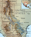
קובץ:Riogranderivermap.png
מראה

גודל התצוגה המקדימה הזאת: 508 × 600 פיקסלים. רזולוציות אחרות: 203 × 240 פיקסלים | 406 × 480 פיקסלים | 1,000 × 1,181 פיקסלים.
לקובץ המקורי (1,000 × 1,181 פיקסלים, גודל הקובץ: 1.95 מ"ב, סוג MIME: image/png)
היסטוריית הקובץ
ניתן ללחוץ על תאריך/שעה כדי לראות את הקובץ כפי שנראה באותו זמן.
| תאריך/שעה | תמונה ממוזערת | ממדים | משתמש | הערה | |
|---|---|---|---|---|---|
| נוכחית | 03:10, 19 באוגוסט 2010 |  | 1,181 × 1,000 (1.95 מ"ב) | Kmusser | == Summary == {{Information |Description=Map showing the Rio Grande drainage basin. |Source={{own}}, Elevation data from SRTM, drainage basin from GTOPO [http://eros.usgs.gov/#/Find_Data/Products_a |
שימוש בקובץ
הדפים הבאים משתמשים בקובץ הזה:
שימוש גלובלי בקובץ
אתרי הוויקי השונים הבאים משתמשים בקובץ זה:
- שימוש באתר af.wikipedia.org
- שימוש באתר azb.wikipedia.org
- שימוש באתר bg.wikipedia.org
- שימוש באתר bh.wikipedia.org
- שימוש באתר br.wikipedia.org
- שימוש באתר ceb.wikipedia.org
- שימוש באתר cs.wikipedia.org
- שימוש באתר da.wikipedia.org
- שימוש באתר de.wikipedia.org
- שימוש באתר el.wikipedia.org
- שימוש באתר en.wikipedia.org
- Rio Grande
- User:Kmusser/Images
- Rio Conchos
- Devils River (Texas)
- San Juan River (Tamaulipas)
- Rio Puerco (Rio Grande tributary)
- Rio Salado (Mexico)
- Prehistory of Colorado
- Florido River
- Battle of Devil's River
- List of longest rivers of the United States (by main stem)
- Trinchera Cave Archeological District
- User:Gareth Griffith-Jones/Talk from September 2011 - present month
- שימוש באתר en.wiktionary.org
- שימוש באתר eo.wikipedia.org
- שימוש באתר es.wikipedia.org
- שימוש באתר fr.wikipedia.org
- שימוש באתר hr.wikipedia.org
- שימוש באתר ht.wikipedia.org
- שימוש באתר hu.wikipedia.org
- שימוש באתר hyw.wikipedia.org
- שימוש באתר id.wikipedia.org
- שימוש באתר incubator.wikimedia.org
- שימוש באתר is.wikipedia.org
- שימוש באתר it.wikipedia.org
- שימוש באתר ja.wikipedia.org
- שימוש באתר ko.wikipedia.org
- שימוש באתר la.wikipedia.org
