
קובץ:Spratly Is since NalGeoMaps.png
אין גרסה ברזולוציה גבוהה יותר.
Spratly_Is_since_NalGeoMaps.png (330 × 354 פיקסלים, גודל הקובץ: 31 ק"ב, סוג MIME: image/png)
| זהו קובץ שמקורו במיזם ויקישיתוף. תיאורו בדף תיאור הקובץ המקורי (בעברית) מוצג למטה. |

|
יש ליצור מחדש את התמונה locator map הזו באמצעות גרפיקה וקטורית כדוגמת קובץ SVG. לפעולה זו מספר יתרונות, כפי שניתן לקרוא (באנגלית) בדף Commons:Media for cleanup. אם ברשותכם קובץ SVG, אנא העלו אותו. לאחר מכן, החליפו תבנית זו בתבנית
{{vector version available|שם הקובץ.svg}} |
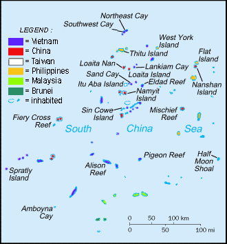
תקציר
| תיאור |
English: Spratly Islands military settlements
Français : Etablissements militaires dans l'archipel des Spratly
Tagalog: Sakop na lupa ng militar sa Pulo ng Kalayaan
中文(简体):南沙群岛的军事区
中文(繁體):南沙群島的軍事區 |
| תאריך יצירה | |
| מקור | Cartothèque Spiridon Manoliu |
| יוצר | Spiridon Manoliu |
רישיון
| ברצוני, בעלי זכויות היוצרים על יצירה זו, לשחרר יצירה זו לנחלת הכלל. זה תקף בכל העולם. יש מדינות שבהן הדבר אינו אפשרי על פי חוק, אם כך: אני מעניק לכל אחד את הזכות להשתמש בעבודה זו לכל מטרה שהיא, ללא תנאים כלשהם, אלא אם כן תנאים כאלה נדרשים על פי חוק. |
היסטוריית הקובץ
ניתן ללחוץ על תאריך/שעה כדי לראות את הקובץ כפי שנראה באותו זמן.
| תאריך/שעה | תמונה ממוזערת | ממדים | משתמש | הערה | |
|---|---|---|---|---|---|
| נוכחית | 09:50, 12 במרץ 2021 | | 354 × 330 (31 ק"ב) | Mlgc1998 | typo |
| 14:46, 13 באפריל 2015 |  | 354 × 330 (18 ק"ב) | RokerHRO | optipng -o7 -i0 → 42.83% decrease | |
| 17:05, 29 במרץ 2009 |  | 354 × 330 (32 ק"ב) | Spiridon Ion Cepleanu | {{Information |Description={{en|1=Spratley Islands military settlements}} {{fr|1=Etablissements militaires dans l'archipel des Spratly}} |Source=Cartothèque Spiridon Manoliu |Author=Spiridon Manoliu |Date=March 29, 2009 |Permission= |other_versions= }} |
שימוש בקובץ
![]() אין בוויקיפדיה דפים המשתמשים בקובץ זה.
אין בוויקיפדיה דפים המשתמשים בקובץ זה.
שימוש גלובלי בקובץ
אתרי הוויקי השונים הבאים משתמשים בקובץ זה:
- שימוש באתר bcl.wikipedia.org
- שימוש באתר br.wikipedia.org
- שימוש באתר cs.wikipedia.org
- שימוש באתר el.wikipedia.org
- שימוש באתר en.wikipedia.org
- Spratly Islands
- Exclusive economic zone
- Republic of Morac-Songhrati-Meads
- East Sea Campaign
- Philippines and the Spratly Islands
- Template:Spratly Islands
- Spratly Islands dispute
- Dangerous Ground (South China Sea)
- List of maritime features in the Spratly Islands
- List of airports in the Spratly Islands
- DK1 rigs
- Great Wall of Sand
- שימוש באתר en.wikinews.org
- שימוש באתר en.wikivoyage.org
- שימוש באתר fa.wikipedia.org
- שימוש באתר fi.wikipedia.org
- שימוש באתר fr.wikipedia.org
- שימוש באתר fr.wiktionary.org
- שימוש באתר gl.wikipedia.org
- שימוש באתר hi.wikipedia.org
- שימוש באתר id.wikipedia.org
- שימוש באתר io.wikipedia.org
- שימוש באתר ja.wikipedia.org
- שימוש באתר ko.wikipedia.org
- שימוש באתר no.wikipedia.org
- שימוש באתר pt.wikipedia.org
- שימוש באתר sv.wikipedia.org
- שימוש באתר th.wikipedia.org
- שימוש באתר tr.wikipedia.org
- שימוש באתר ug.wikipedia.org
- שימוש באתר vi.wikipedia.org