
קובץ:Third Ypres - Map Showing Progress in the Ypres Area..jpg
גודל התצוגה המקדימה הזאת: 349 × 598 פיקסלים. רזולוציות אחרות: 140 × 240 פיקסלים | 280 × 480 פיקסלים | 448 × 768 פיקסלים | 597 × 1,024 פיקסלים | 1,194 × 2,048 פיקסלים | 2,566 × 4,400 פיקסלים.
לקובץ המקורי (2,566 × 4,400 פיקסלים, גודל הקובץ: 4.63 מ"ב, סוג MIME: image/jpeg)
| זהו קובץ שמקורו במיזם ויקישיתוף. תיאורו בדף תיאור הקובץ המקורי (בעברית) מוצג למטה. |
תקציר
| כותר |
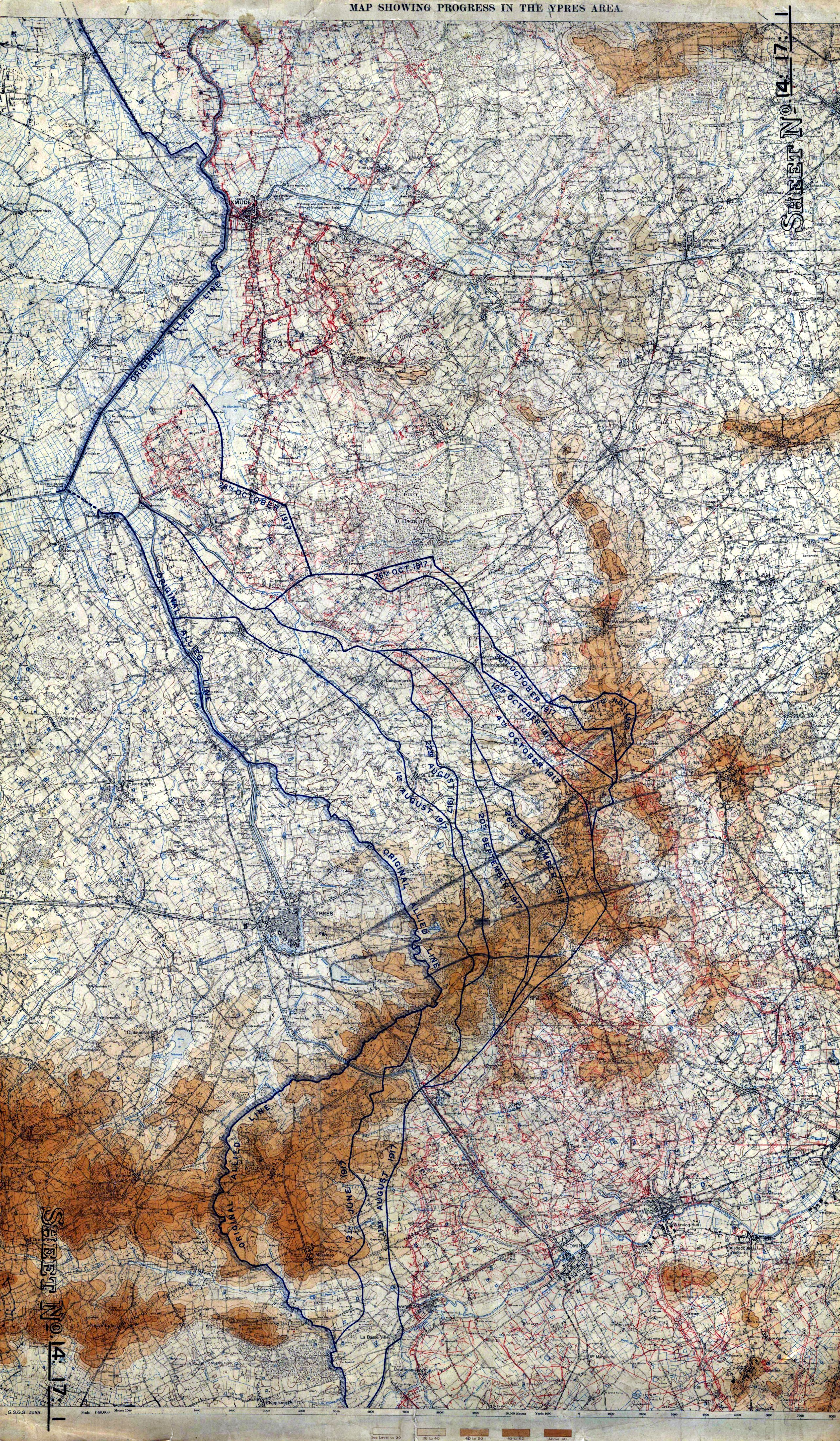
English: Map Showing Progress in the Ypres Area |
|||||||||||||||||||||||
| תיאור |
English: Map showing progress in the Ypres area, 1 Aug to 17 Nov, 1917. 8th edition. GSGS 3588. 1:40,000. War Office. |
|||||||||||||||||||||||
| תאריך יצירה | ||||||||||||||||||||||||
| מקור |
The National Archives, Kew (FO 925/24005) http://blog.awm.gov.au/awm/wp-content/uploads/maps/Ypres_Offensive.pdf |
|||||||||||||||||||||||
| יוצר |
War Office. General Staff. Geographical Section, Field Service Battalion, Royal Engineers |
|||||||||||||||||||||||
| אישורים והיתרים (שימוש חוזר בקובץ זה) |
|
|||||||||||||||||||||||
| Geotemporal data | ||||||||||||||||||||||||
| תאריך מתואר | ||||||||||||||||||||||||
| Map location | Ieper | |||||||||||||||||||||||
| Map type | trench map | |||||||||||||||||||||||
| קנה מידה | 1:40000 | |||||||||||||||||||||||
| Heading |
 |
|||||||||||||||||||||||
| Bounding box |
|
|||||||||||||||||||||||
| Georeferencing | ||||||||||||||||||||||||
| Bibliographic data | ||||||||||||||||||||||||
| Map sheet | 14:17:1 | |||||||||||||||||||||||
| שפה | אנגלית | |||||||||||||||||||||||
| מפרסם |
Royal Engineers |
|||||||||||||||||||||||
| Archival data | ||||||||||||||||||||||||
| אוסף |
|
|||||||||||||||||||||||

היסטוריית הקובץ
ניתן ללחוץ על תאריך/שעה כדי לראות את הקובץ כפי שנראה באותו זמן.
| תאריך/שעה | תמונה ממוזערת | ממדים | משתמש | הערה | |
|---|---|---|---|---|---|
| נוכחית | 22:44, 10 בפברואר 2009 | | 4,400 × 2,566 (4.63 מ"ב) | Labattblueboy | {{Information |Description=Map showing progress in the Ypres area, 1 Aug to 17 Nov, 1917. 8th edition. GSGS 3588. 1:40,000. War Office. |Source= The National Archives, Kew (FO 925/24005)<br>http://blog.awm.gov.au/awm/wp-content/uploads/maps/Ypres_Offensiv |
| 22:22, 10 בפברואר 2009 |  | 4,400 × 2,566 (3.84 מ"ב) | Labattblueboy | {{Information |Description=Map showing progress in the Ypres area, 1 Aug to 17 Nov, 1917. 8th edition. GSGS 3588. 1:40,000. War Office. |Source= The National Archives, Kew (FO 925/24005)<br>http://blog.awm.gov.au/awm/wp-content/uploads/maps/Ypres_Offensiv |
שימוש בקובץ
הדף הבא משתמש בקובץ הזה:
שימוש גלובלי בקובץ
אתרי הוויקי השונים הבאים משתמשים בקובץ זה:
- שימוש באתר en.wikipedia.org
- Capture of Hill 60 (Western Front)
- History of the Great War
- 20th (Light) Division
- Ypres Salient
- Battle of Messines (1917)
- Battle of Langemarck (1917)
- 35th Division (United Kingdom)
- Battle of Pilckem Ridge
- Talk:Battle of Pilckem Ridge
- Eingreif division
- The Menin Road (painting)
- Hooge in World War I
- Actions of the Bluff, 1916
- Actions of St Eloi Craters
- Gheluvelt Plateau actions, July–August 1917
- Capture of Westhoek
- Action on the Polderhoek Spur
- Action of 22 October 1917
- Night action of 1/2 December 1917
- Action of 22 August 1917
- User:Mkan18/sandbox
- User:Mkan18/Ypres Salient
- שימוש באתר es.wikipedia.org
- שימוש באתר fr.wikipedia.org
- שימוש באתר ur.wikipedia.org
- שימוש באתר www.wikidata.org