
קובץ:Vinson-Map.jpg

גודל התצוגה המקדימה הזאת: 626 × 599 פיקסלים. רזולוציות אחרות: 251 × 240 פיקסלים | 501 × 480 פיקסלים | 802 × 768 פיקסלים | 1,070 × 1,024 פיקסלים | 2,139 × 2,048 פיקסלים | 3,207 × 3,070 פיקסלים.
לקובץ המקורי (3,207 × 3,070 פיקסלים, גודל הקובץ: 5.48 מ"ב, סוג MIME: image/jpeg)
| זהו קובץ שמקורו במיזם ויקישיתוף. תיאורו בדף תיאור הקובץ המקורי (בעברית) מוצג למטה. |
| תיאור |
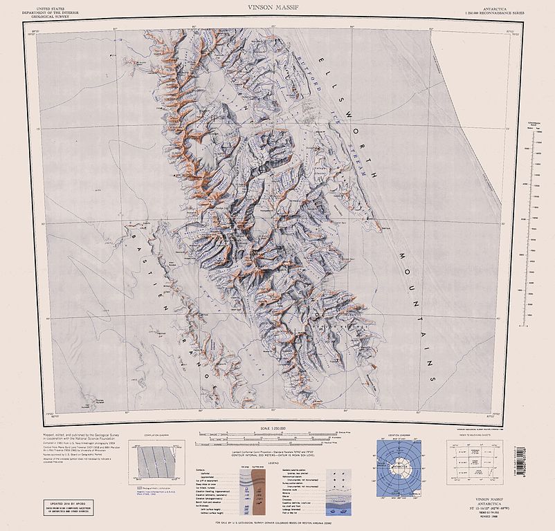
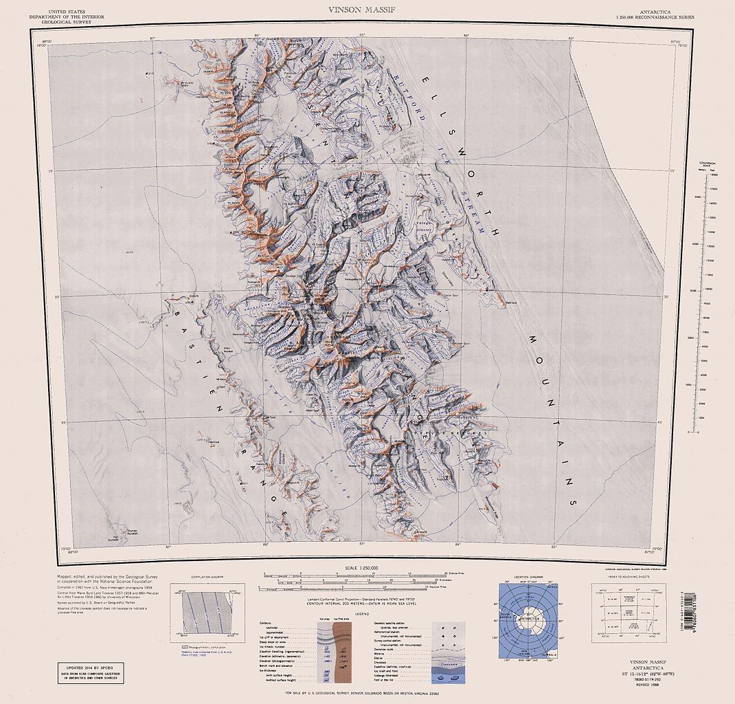
English: Map of Antarctica by the United States Antarctic Resource Center of the US Geological Survey (USGS). |
| תאריך יצירה | |
| מקור | https://usarc.usgs.gov/drgs/dir1/c78082s1.jpg |
| יוצר | United States Department of the Interior: Geological Survey |
| גרסאות אחרות |
Trimmed and updated version of Wikimedia Commons Image:C78082s1_Ant.Map_Vinson_Massif.jpg. |
This image is in the public domain in the United States because it only contains materials that originally came from the United States Geological Survey, an agency of the United States Department of the Interior. For more information, see the official USGS copyright policy.
|
היסטוריית הקובץ
ניתן ללחוץ על תאריך/שעה כדי לראות את הקובץ כפי שנראה באותו זמן.
| תאריך/שעה | תמונה ממוזערת | ממדים | משתמש | הערה | |
|---|---|---|---|---|---|
| נוכחית | 19:25, 22 בינואר 2014 | | 3,070 × 3,207 (5.48 מ"ב) | Apcbg | Updated with data from SCAR Composite Gazetteer of Antarctica and other sources. |
| 10:11, 27 באוגוסט 2013 |  | 3,070 × 3,207 (5.47 מ"ב) | Apcbg | Updated with data from SCAR Composite Gazetteer of Antarctica and other sources. | |
| 19:34, 9 ביולי 2011 |  | 3,070 × 3,207 (5.46 מ"ב) | Apcbg | Updated with data from SCAR Composite Gazetteer of Antarctica and other sources. | |
| 20:34, 8 במרץ 2011 |  | 3,070 × 3,207 (5.47 מ"ב) | Apcbg | Updated with data from SCAR Composite Gazetteer of Antarctica and other sources. | |
| 19:52, 13 באוקטובר 2010 |  | 3,070 × 3,207 (5.45 מ"ב) | Apcbg | Updated with data from SCAR Composite Gazetteer of Antarctica and other sources. | |
| 13:27, 30 בינואר 2007 |  | 3,070 × 3,207 (5.4 מ"ב) | Apcbg | Map of Antarctica by the United States Antarctic Ressource Center of the US Geological Society. Trimmed version of Wikimedia image C78082s1_Ant.Map_Vinson_Massif.jpg {{PD-US}} Copyrights and Trademarks USGS-authored or produced data and information are |
שימוש בקובץ
הדפים הבאים משתמשים בקובץ הזה:
- אוכף זבגור
- אוכף פודגורה
- הגאזט האנטארקטי המשווה SCAR
- הר אוסבורן (אנטארקטיקה)
- הר אטקינסון (אנטארקטיקה)
- הר אלן (הרי אלזוורת')
- הר אנדרסון (אנטארקטיקה)
- הר בנטלי (אנטארקטיקה)
- הר ברסקין
- הר ג'מפר (אנטארקטיקה)
- הר גוזור
- הר דייוויס (אנטארקטיקה)
- הר הייל (אנטארקטיקה)
- הר טוד (ארץ אלזוורת')
- הר לאנדולט
- הר ליפטאק
- הר מילטון (אנטארקטיקה)
- הר סטרייבינג
- הר פרס (אנטארקטיקה)
- הר קראדוק
- מסיב קראדוק
- מעבר קאסילאג
- מעבר קוסטינברוד
- מצוק ויליס (אנטארקטיקה)
- מצוק ורגאבה
- עמק סיקרה
- פסגת אייר
- פסגת איצ'רה
- פסגת אלפרינג
- פסגת ברגיסון
- פסגת ברוגייר
- פסגת גובש
- פסגת לונג (אנטארקטיקה)
- פסגת לישנס
- פסגת מודרן
- פסגת נבסקה
- פסגת סטיקל
- פסגת פריסטרה
- פסגת צ'פלין
- פסגת קושלה
- פסגת קרושה
- קרחון אלן
- קרחון אמברי
- קרחון אסטר
- קרחון בולגראד
- קרחון בורדניס
- קרחון בנדר
- קרחון ברוק (אנטארקטיקה)
- קרחון גאבארה
- קרחון גרילה
- קרחון גררו
- קרחון דייטר
- קרחון דלה פיה
- קרחון דרמה
- קרחון הינקלי
- קרחון וסבכר
- קרחון יאנג
- קרחון מינסוטה
- קרחון נימיץ
- קרחון סירמה
- קרחון פונפון
- קרחון צ'רבלאטי
- קרחון קארי (אנטארקטיקה)
- קרחון קורניקר
- קרחון רומיאנה
- קרחון תומאס
- רכס אוון (אנטארקטיקה)
- רכס אפרלי
- רכס בסטיאן
- רכס סנטינל (אנטארקטיקה)
- רכס פרובודה
- רמת פטוואר
- שלוחת גילברט
שימוש גלובלי בקובץ
אתרי הוויקי השונים הבאים משתמשים בקובץ זה:
- שימוש באתר ar.wikipedia.org
- שימוש באתר ast.wikipedia.org
- שימוש באתר az.wikipedia.org
- Mirovyane zirvəsi
- Zimornitsa zirvəsi
- Fuça zirvəsi
- Bezden zirvəsi
- Oreşak zirvəsi
- Qolemani zirvəsi
- Marsa buzlağı
- Patleyna buzlağı
- Embree buzlağı
- Kopsis buzlağı
- Padala buzlağı
- Ellen buzlağı
- Fonfon buzlağı
- Gerila buzlağı
- Rumyana buzlağı
- Delyo buzlağı
- Burdenis buzlağı
- Arapya buzlağı
- Pulpudeva buzlağı
- Mamarçev zirvəsi
- Rutford
- שימוש באתר bg.wikipedia.org
- שימוש באתר ca.wikipedia.org
- שימוש באתר ceb.wikipedia.org