
קובץ:USA territorial growth.gif

גודל התצוגה המקדימה הזאת: 800 × 498 פיקסלים. רזולוציות אחרות: 320 × 199 פיקסלים | 640 × 398 פיקסלים | 921 × 573 פיקסלים.
לקובץ המקורי (921 × 573 פיקסלים, גודל הקובץ: 2.01 מ"ב, סוג MIME: image/gif, בלולאה, 10 תמונות, 50 שניות)
| זהו קובץ שמקורו במיזם ויקישיתוף. תיאורו בדף תיאור הקובץ המקורי (בעברית) מוצג למטה. |
תקציר
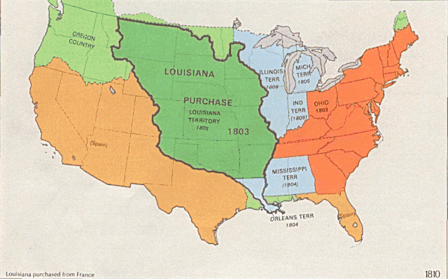
| תיאור |
English: US territorial growth 1810–1920, based on the PD USGS maps in Category:Territorial growth maps of the United States.
See key below for explanation of colors.  |
||||||
| מקור |
|
||||||
| יוצר |
|
||||||
| גרסאות אחרות |
|

רישיון
This image is in the public domain in the United States because it only contains materials that originally came from the United States Geological Survey, an agency of the United States Department of the Interior. For more information, see the official USGS copyright policy.
|
היסטוריית הקובץ
ניתן ללחוץ על תאריך/שעה כדי לראות את הקובץ כפי שנראה באותו זמן.
| תאריך/שעה | תמונה ממוזערת | ממדים | משתמש | הערה | |
|---|---|---|---|---|---|
| נוכחית | 04:39, 31 במאי 2006 | | 573 × 921 (2.01 מ"ב) | Roke~commonswiki | longer interval, 3 seconds --> 5 seconds |
| 15:21, 30 במאי 2006 |  | 573 × 921 (2.67 מ"ב) | Roke~commonswiki | US territorial growth 1810-1920, based on the USGS maps in commons:Category:USA Territorial Growth Maps, put together in Corel Painter IX. The individual maps have this licence: {{PD-USGov-USGS}} If it is necessary for me to licence my contributio |
שימוש בקובץ
הדף הבא משתמש בקובץ הזה:
שימוש גלובלי בקובץ
אתרי הוויקי השונים הבאים משתמשים בקובץ זה:
- שימוש באתר bn.wikipedia.org
- שימוש באתר en.wikipedia.org
- שימוש באתר es.wikipedia.org
- שימוש באתר fa.wikipedia.org
- שימוש באתר fy.wikipedia.org
- שימוש באתר ha.wikipedia.org
- שימוש באתר nl.wikipedia.org
- שימוש באתר pnb.wikipedia.org
- שימוש באתר ru.wikipedia.org
- שימוש באתר ru.wikinews.org
- שימוש באתר sr.wikipedia.org
- שימוש באתר tr.wikipedia.org
- שימוש באתר ur.wikipedia.org
- שימוש באתר uz.wikipedia.org
- שימוש באתר www.wikidata.org