
קובץ:Anatolia1300.png
אין גרסה ברזולוציה גבוהה יותר.
Anatolia1300.png (535 × 330 פיקסלים, גודל הקובץ: 81 ק"ב, סוג MIME: image/png)
| זהו קובץ שמקורו במיזם ויקישיתוף. תיאורו בדף תיאור הקובץ המקורי (בעברית) מוצג למטה. |
תקציר
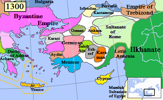
| תיאור |
English: Map of the Anatolia region in AD 1300.
(Partially based on Euratlas map of Europe, 1300.) |
| תאריך יצירה | |
| מקור | נוצר על־ידי מעלה היצירה |
| יוצר | Gabagool |
| גרסאות אחרות |
.png)
רישיון
אני, בעל זכויות היוצרים על עבודה זו, מפרסם בזאת את העבודה תחת הרישיון הבא:
הקובץ הזה מתפרסם לפי תנאי רישיון קריאייטיב קומונז ייחוס 3.0 לא מותאם.
- הנכם רשאים:
- לשתף – להעתיק, להפיץ ולהעביר את העבודה
- לערבב בין עבודות – להתאים את העבודה
- תחת התנאים הבאים:
- ייחוס – יש לתת ייחוס הולם, לתת קישור לרישיון, ולציין אם נעשו שינויים. אפשר לעשות את זה בכל צורה סבירה, אבל לא בשום צורה שמשתמע ממנה שמעניק הרישיון תומך בך או בשימוש שלך.
היסטוריית הקובץ
ניתן ללחוץ על תאריך/שעה כדי לראות את הקובץ כפי שנראה באותו זמן.
| תאריך/שעה | תמונה ממוזערת | ממדים | משתמש | הערה | |
|---|---|---|---|---|---|
| נוכחית | 19:46, 20 בינואר 2017 | | 330 × 535 (81 ק"ב) | Cplakidas | fixing Dodecanese: Menteshe never controlled the offshore islands; they remained Byzantine until the Hospitallers or Genoese of Chios took them. |
| 01:26, 18 באפריל 2009 |  | 330 × 535 (64 ק"ב) | Gabagool | Byzantine color lighter. New Armenia -> Little Armenia | |
| 22:12, 2 באפריל 2009 |  | 330 × 535 (64 ק"ב) | Gabagool | added mamluks | |
| 19:36, 31 במרץ 2009 |  | 330 × 535 (63 ק"ב) | Gabagool | {{Information |Description={{en|1=Map of the Anatolia region in AD 1300. (Partially based on Euratlas map of Europe, 1300.)}} |Source=Own work by uploader |Author=Gabagool |Date=2009-03-31 |Permission= |other_versions= }} <!--{{ImageUp |
שימוש בקובץ
הדף הבא משתמש בקובץ הזה:
שימוש גלובלי בקובץ
אתרי הוויקי השונים הבאים משתמשים בקובץ זה:
- שימוש באתר als.wikipedia.org
- שימוש באתר ar.wikipedia.org
- שימוש באתר arz.wikipedia.org
- שימוש באתר azb.wikipedia.org
- שימוש באתר az.wikipedia.org
- שימוש באתר ba.wikipedia.org
- שימוש באתר bg.wikipedia.org
- שימוש באתר bn.wikipedia.org
- שימוש באתר ca.wikipedia.org
- שימוש באתר cs.wikipedia.org
- שימוש באתר de.wikipedia.org
- שימוש באתר el.wikipedia.org
- שימוש באתר en.wikipedia.org