
קובץ:Austria extreme points.png
גודל התצוגה המקדימה הזאת: 800 × 439 פיקסלים. רזולוציות אחרות: 320 × 176 פיקסלים | 820 × 450 פיקסלים.
לקובץ המקורי (820 × 450 פיקסלים, גודל הקובץ: 47 ק"ב, סוג MIME: image/png)
| זהו קובץ שמקורו במיזם ויקישיתוף. תיאורו בדף תיאור הקובץ המקורי (בעברית) מוצג למטה. |

|
This map has been uploaded by Electionworld from en.wikipedia.org to enable the |
תקציר
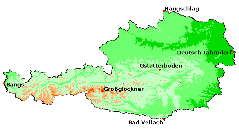
The extreme points of Austria.
רישיון
Stemonitis, בעל זכויות היוצרים על היצירה הזאת, מפרסם אותה בזאת תחת הרישיון הבא:

|
מוענקת בכך הרשות להעתיק, להפיץ או לשנות את המסמך הזה, לפי תנאי הרישיון לשימוש חופשי במסמכים של גנו, גרסה 1.2 או כל גרסה מאוחרת יותר שתפורסם על־ידי המוסד לתוכנה חופשית; ללא פרקים קבועים, ללא טקסט עטיפה קדמית וללא טקסט עטיפה אחורית. עותק של הרישיון כלול בפרק שכותרתו הרישיון לשימוש חופשי במסמכים של גנו. |
| הקובץ הזה מתפרסם לפי תנאי רישיון קריאייטיב קומונז ייחוס-שיתוף זהה 3.0 לא מותאם. | ||
| ייחוס: Stemonitis | ||
| ||
| תבנית רישוי זו הוספה לקובץ כחלק מעדכון רישיון GFDL. |
היסטוריית הקובץ
ניתן ללחוץ על תאריך/שעה כדי לראות את הקובץ כפי שנראה באותו זמן.
| תאריך/שעה | תמונה ממוזערת | ממדים | משתמש | הערה | |
|---|---|---|---|---|---|
| נוכחית | 01:50, 24 בדצמבר 2006 | | 450 × 820 (47 ק"ב) | Electionworld | {{ew|en|Stemonitis}} == Summary == The extreme points of Austria. == Licensing == {{GFDL-user|Stemonitis}} |
שימוש בקובץ
הדף הבא משתמש בקובץ הזה:
שימוש גלובלי בקובץ
אתרי הוויקי השונים הבאים משתמשים בקובץ זה:
- שימוש באתר bs.wikipedia.org
- שימוש באתר de.wikipedia.org
- GEONAM Österreich
- Geographie Österreichs
- Vorarlberger Geographisches Informationssystem
- Österreichische Karte
- Geoland.at
- Digitales Oberösterreichisches Raum-Informations-System
- ViennaGIS
- GIS-Steiermark
- Kärntner Geografisches Informationssystem
- Karten & Geoinformation in Niederösterreich
- Hora.gv.at
- Tiroler Rauminformationssystem
- Vorlage:Navigationsleiste GIS in Österreich
- Salzburger Geographisches Informationssystem
- Altlastenatlas
- GIS-Burgenland
- שימוש באתר en.wikipedia.org
- שימוש באתר hu.wikipedia.org
- שימוש באתר ka.wikipedia.org
- שימוש באתר nn.wikipedia.org
- שימוש באתר no.wikipedia.org
- שימוש באתר pt.wikipedia.org