
קובץ:KT boundary 054.jpg

גודל התצוגה המקדימה הזאת: 800 × 600 פיקסלים. רזולוציות אחרות: 320 × 240 פיקסלים | 640 × 480 פיקסלים | 1,024 × 768 פיקסלים | 1,280 × 960 פיקסלים | 1,600 × 1,200 פיקסלים.
לקובץ המקורי (1,600 × 1,200 פיקסלים, גודל הקובץ: 860 ק"ב, סוג MIME: image/jpeg)
| זהו קובץ שמקורו במיזם ויקישיתוף. תיאורו בדף תיאור הקובץ המקורי (בעברית) מוצג למטה. |
תקציר
| תיאור |
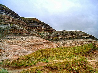
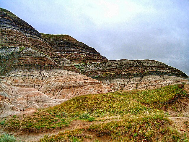
English: Badlands near Drumheller, Alberta, where erosion has exposed the K-Pg boundary. |
| תאריך יצירה | 12 באוגוסט 2005 (תאריך העלאה מקורי) |
| מקור | photo G Larson; Transferred from en.wikipedia |
| יוצר | Original uploader was Glenlarson at en.wikipedia |
| אישורים והיתרים (שימוש חוזר בקובץ זה) |
PD-User |
רישיון
| |
תמונה זו שוחררה לרשות הציבור על ידי היוצר שלה, Glenlarson במיזם Wikimedia Commons. זה תקף בכל העולם. במקרה ששחרור לרשות הציבור לא אפשרי מבחינה חוקית: |
יומן העלאה מקורי
תיאור הקובץ המקורי נמצא כאן. כל שמות המשתמשים הבאים מתייחסים ל-en.wikipedia.
- 2005-08-12 20:57 Glenlarson 1600×1200×8 (769372 bytes) KT boundary photo G Larson {{pd}}
היסטוריית הקובץ
ניתן ללחוץ על תאריך/שעה כדי לראות את הקובץ כפי שנראה באותו זמן.
| תאריך/שעה | תמונה ממוזערת | ממדים | משתמש | הערה | |
|---|---|---|---|---|---|
| נוכחית | 15:23, 12 באפריל 2022 | | 1,200 × 1,600 (860 ק"ב) | J. N. Squire | Colors, contrast and saturation adjusted |
| 21:18, 19 בינואר 2008 |  | 1,200 × 1,600 (751 ק"ב) | EuTuga | {{Information |Description={{en|Badlands near Drumheller, Alberta, where erosion has exposed the KT boundary.}} |Source=photo G Larson; Transferred from [http://en.wikipedia.org en.wikipedia] |Date=2005-08-12 (original upload date) |
שימוש בקובץ
הדף הבא משתמש בקובץ הזה:
שימוש גלובלי בקובץ
אתרי הוויקי השונים הבאים משתמשים בקובץ זה:
- שימוש באתר af.wikipedia.org
- שימוש באתר ar.wikipedia.org
- שימוש באתר bs.wikipedia.org
- שימוש באתר ca.wikipedia.org
- שימוש באתר cs.wikipedia.org
- שימוש באתר da.wikipedia.org
- שימוש באתר de.wikipedia.org
- שימוש באתר el.wikipedia.org
- שימוש באתר en.wikipedia.org
- שימוש באתר en.wikibooks.org
- שימוש באתר en.wikiversity.org
- שימוש באתר eo.wikipedia.org
- שימוש באתר es.wikipedia.org
- שימוש באתר fa.wikipedia.org
- שימוש באתר fr.wikipedia.org
- שימוש באתר gl.wikipedia.org
- שימוש באתר hu.wikipedia.org
- שימוש באתר id.wikipedia.org
- שימוש באתר it.wikipedia.org
- שימוש באתר ja.wikipedia.org
- שימוש באתר kw.wikipedia.org
- שימוש באתר la.wikipedia.org
- שימוש באתר mk.wikipedia.org
- שימוש באתר ml.wikipedia.org
- שימוש באתר ms.wikipedia.org
- שימוש באתר nn.wikipedia.org
- שימוש באתר no.wikipedia.org
- שימוש באתר oc.wikipedia.org
- שימוש באתר pl.wikipedia.org
- שימוש באתר pt.wikipedia.org
- שימוש באתר ro.wikipedia.org
- שימוש באתר ru.wikipedia.org