
קובץ:Saint-Barthélemy collectivity relief location map.jpg

גודל התצוגה המקדימה הזאת: 800 × 526 פיקסלים. רזולוציות אחרות: 320 × 210 פיקסלים | 640 × 420 פיקסלים | 1,024 × 673 פיקסלים | 1,175 × 772 פיקסלים.
לקובץ המקורי (1,175 × 772 פיקסלים, גודל הקובץ: 172 ק"ב, סוג MIME: image/jpeg)
| זהו קובץ שמקורו במיזם ויקישיתוף. תיאורו בדף תיאור הקובץ המקורי (בעברית) מוצג למטה. |
תקציר
| מיקום המצלמה | | תמונה זו ותמונות נוספות במיקום: OpenStreetMap |
|---|
| תיאור |
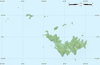
English: Blank physical map of the overseas collectivity of Saint Barthélemy, France, for geo-location purpose.
Français : Carte physique vierge de la collectivité d'outre-mer de Saint-Barthélemy, France, destinée à la géolocalisation. Scales: 1:372,000 (precision: 93 m) for the topography; 1:4,720,000 (precision: 1,180 m) for the bathymetry
Geographic limits of the map:
|
||
| תאריך יצירה | |||
| מקור |
נוצר על־ידי מעלה היצירה
|
||
| יוצר | Eric Gaba (Sting - fr:Sting) | ||
| אישורים והיתרים (שימוש חוזר בקובץ זה) |
|
||
| גרסאות אחרות |
|


רישיון
Eric Gaba, Wikimedia Commons user Sting, בעל זכויות היוצרים על היצירה הזאת, מפרסם אותה בזאת תחת הרישיונות הבאים:
הקובץ הזה מתפרסם לפי תנאי רישיון קריאייטיב קומונז ייחוס-שיתוף זהה 3.0 לא מותאם.
ייחוס: Eric Gaba, Wikimedia Commons user Sting
- הנכם רשאים:
- לשתף – להעתיק, להפיץ ולהעביר את העבודה
- לערבב בין עבודות – להתאים את העבודה
- תחת התנאים הבאים:
- ייחוס – יש לתת ייחוס הולם, לתת קישור לרישיון, ולציין אם נעשו שינויים. אפשר לעשות את זה בכל צורה סבירה, אבל לא בשום צורה שמשתמע ממנה שמעניק הרישיון תומך בך או בשימוש שלך.
- שיתוף זהה – אם תיצרו רמיקס, תשנו, או תבנו על החומר, חובה עליכם להפיץ את התרומות שלך לפי תנאי רישיון זהה או תואם למקור.

|
מוענקת בכך הרשות להעתיק, להפיץ או לשנות את המסמך הזה, לפי תנאי הרישיון לשימוש חופשי במסמכים של גנו, גרסה 1.2 או כל גרסה מאוחרת יותר שתפורסם על־ידי המוסד לתוכנה חופשית; ללא פרקים קבועים, ללא טקסט עטיפה קדמית וללא טקסט עטיפה אחורית. עותק של הרישיון כלול בפרק שכותרתו הרישיון לשימוש חופשי במסמכים של גנו. |
הנכם מוזמנים לבחור את הרישיון הרצוי בעיניכם.
היסטוריית הקובץ
ניתן ללחוץ על תאריך/שעה כדי לראות את הקובץ כפי שנראה באותו זמן.
| תאריך/שעה | תמונה ממוזערת | ממדים | משתמש | הערה | |
|---|---|---|---|---|---|
| נוכחית | 00:14, 19 ביולי 2010 | | 772 × 1,175 (172 ק"ב) | Sting | Color profile |
| 04:39, 26 בפברואר 2010 |  | 772 × 1,175 (167 ק"ב) | Sting | == {{int:filedesc}} == {{Location|17|55|30|N|62|51|45|W|scale:50000}} <br/> {{Information |Description={{en|Blank physical map of the overseas collectivity of Saint Barthélemy, France |
שימוש בקובץ
הדף הבא משתמש בקובץ הזה:
שימוש גלובלי בקובץ
אתרי הוויקי השונים הבאים משתמשים בקובץ זה:
- שימוש באתר ar.wikipedia.org
- שימוש באתר ast.wikipedia.org
- שימוש באתר bg.wikipedia.org
- שימוש באתר bs.wikipedia.org
- שימוש באתר ceb.wikipedia.org
- שימוש באתר ckb.wikipedia.org
- שימוש באתר da.wikipedia.org
- שימוש באתר de.wikipedia.org
- שימוש באתר en.wikipedia.org
- שימוש באתר eo.wikipedia.org
- שימוש באתר es.wikipedia.org
- שימוש באתר fa.wikipedia.org
- שימוש באתר fr.wikipedia.org
- Discussion utilisateur:Pethrus
- Gustavia (Saint-Barthélemy)
- Projet:Cartographie/Cartes standards/France
- Modèle:Géolocdual/Saint-Barthélemy
- Modèle:Géolocalisation/Saint-Barthélemy
- Wikipédia:Atelier graphique/Cartes/Archives/avril 2010
- Morne de Vitet
- Réserve naturelle nationale de Saint-Barthélemy Nicole-Aussedat
- Île Fourchue
- Île Chevreau
- Île Frégate (France)
- Île le Boulanger
- Île Coco
- Pain de Sucre (Saint-Barthélemy)
- Île Pelé
- Île Petit Jean
- Île Toc Vers
- La Tortue (Saint-Barthélemy)
- Liste des mammifères à Saint-Barthélemy
- שימוש באתר hr.wikipedia.org