
קובץ:UAE en-map.png
גודל התצוגה המקדימה הזאת: 755 × 600 פיקסלים. רזולוציות אחרות: 302 × 240 פיקסלים | 605 × 480 פיקסלים | 967 × 768 פיקסלים | 1,280 × 1,017 פיקסלים | 1,414 × 1,123 פיקסלים.
לקובץ המקורי (1,414 × 1,123 פיקסלים, גודל הקובץ: 214 ק"ב, סוג MIME: image/png)
| זהו קובץ שמקורו במיזם ויקישיתוף. תיאורו בדף תיאור הקובץ המקורי (בעברית) מוצג למטה. |
תקציר
| תיאור |
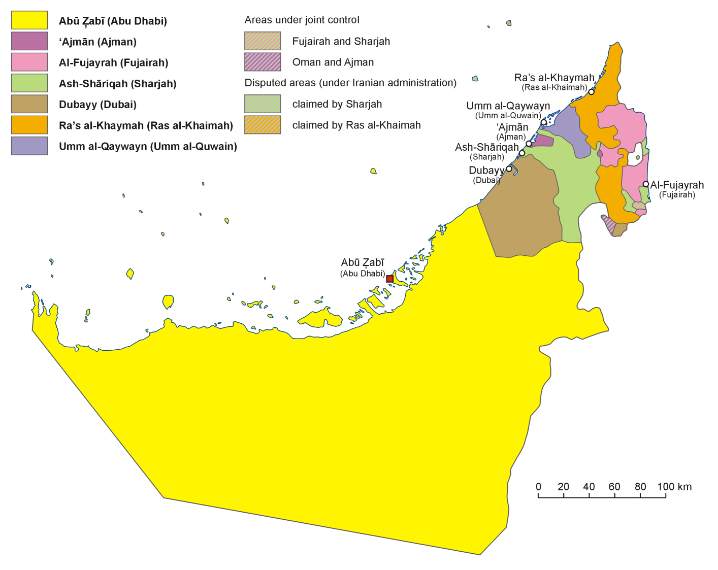
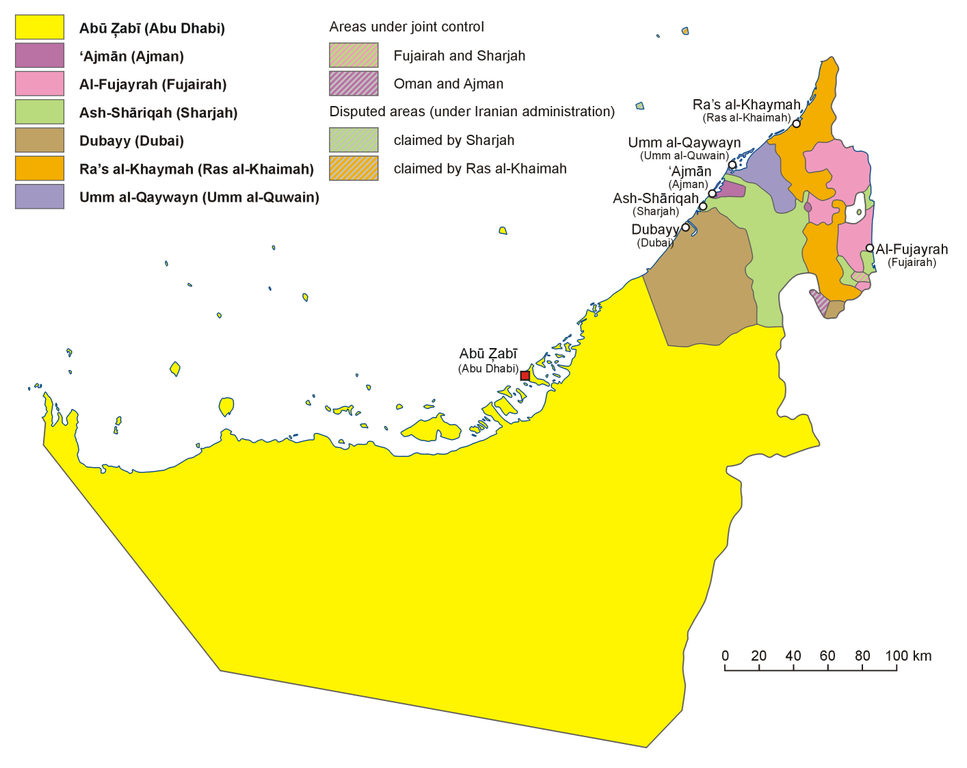
English: Administrative map of the United Arab Emirates in English
فارسی: نقشهٔ اداری امارات متحده عربی به فارسی
Français : Carte des divisions administratives des Emirats arabes unis en Anglais
Italiano: Carta politica degli Emirati Arabi Uniti, in inglese
Hrvatski: Politički zemljovid Ujedinjenih Arapskih Emirata, inačica na engleskom
Polski: Mapa administracyjna Zjednoczonych Emiratów Arabskich, wersja anglojęzyczna
日本語: アラブ首長国連邦の行政区分図(英語版)
Српски / srpski: Политичка карта Уједињених Арапских Емирата, верзија на енглеском језику. |
| תאריך יצירה | |
| מקור | נוצר על־ידי מעלה היצירה, based on map of the United Arab Emirates published in Wielki Encyklopedyczny Atlas Świata (The Great Encyclopedian World Atlas), vol. 10 Azja Południowo-Zachodnia (Southwest Asia), Polish Scientific Publishers PWN, Warsaw 2006, p. 76-78 |
| יוצר | Aotearoa |
| גרסאות אחרות |
Derivative works of this file: |
רישיון
אני, בעל זכויות היוצרים על עבודה זו, מפרסם בזאת את העבודה תחת הרישיון הבא:

|
מוענקת בכך הרשות להעתיק, להפיץ או לשנות את המסמך הזה, לפי תנאי הרישיון לשימוש חופשי במסמכים של גנו, גרסה 1.2 או כל גרסה מאוחרת יותר שתפורסם על־ידי המוסד לתוכנה חופשית; ללא פרקים קבועים, ללא טקסט עטיפה קדמית וללא טקסט עטיפה אחורית. עותק של הרישיון כלול בפרק שכותרתו הרישיון לשימוש חופשי במסמכים של גנו. |
| הקובץ הזה מתפרסם לפי תנאי רישיון קריאייטיב קומונז ייחוס-שיתוף זהה 3.0 לא מותאם. | ||
| ||
| תבנית רישוי זו הוספה לקובץ כחלק מעדכון רישיון GFDL. |
היסטוריית הקובץ
ניתן ללחוץ על תאריך/שעה כדי לראות את הקובץ כפי שנראה באותו זמן.
| תאריך/שעה | תמונה ממוזערת | ממדים | משתמש | הערה | |
|---|---|---|---|---|---|
| נוכחית | 13:52, 13 באוגוסט 2013 | | 1,123 × 1,414 (214 ק"ב) | Aotearoa | Reverted to version as of 20:41, 5 January 2007 |
| 20:47, 12 באוגוסט 2013 |  | 1,123 × 1,414 (184 ק"ב) | Cromium | Clarified by removing transliterations of the emirate names, leaving just the English names used in the relevant Wikipedia articles | |
| 23:41, 5 בינואר 2007 |  | 1,123 × 1,414 (214 ק"ב) | Aotearoa | Administrative map of United Arab Emirates. Created by Aotearoa |
שימוש בקובץ
הדף הבא משתמש בקובץ הזה:
שימוש גלובלי בקובץ
אתרי הוויקי השונים הבאים משתמשים בקובץ זה:
- שימוש באתר ace.wikipedia.org
- שימוש באתר af.wikipedia.org
- שימוש באתר ang.wikipedia.org
- שימוש באתר ar.wikipedia.org
- שימוש באתר ast.wikipedia.org
- שימוש באתר bn.wikipedia.org
- שימוש באתר br.wikipedia.org
- שימוש באתר cs.wikipedia.org
- Spojené arabské emiráty
- Abú Zabí
- Dubaj (emirát)
- Vlajka Spojených arabských emirátů
- Rás al-Chajma (emirát)
- Fudžajra (emirát)
- Abú Zabí (emirát)
- Šablona:Emiráty SAE
- Adžmán (emirát)
- Šardžá (emirát)
- Dubaj
- Fudžajra
- Rás al-Chajma
- Šardžá
- Umm al-Kuvajn (emirát)
- Emiráty Spojených arabských emirátů
- Adžmán
- Umm al-Kuvajn
- שימוש באתר de.wikipedia.org
- שימוש באתר en.wikipedia.org
- United Arab Emirates
- User:Jonny-mt/Gallery of current first-level administrative country subdivisions maps
- Template:UAE midsize imagemap with emirate names
- Wikipedia talk:WikiProject Western Asia/Archive 1
- December 1971
- Al Karama, United Arab Emirates
- List of British representatives in the Trucial States
- שימוש באתר eo.wikipedia.org
- שימוש באתר es.wikipedia.org