קובץ:African-civilizations-map-pre-colonial.svg
תוכן הדף אינו נתמך בשפות אחרות.
מתוך ויקיפדיה, האנציקלופדיה החופשית

לקובץ המקורי(קובץ SVG, הגודל המקורי: 1,390 × 1,295 פיקסלים, גודל הקובץ: 488 ק"ב)

ויקישיתוף זהו קובץ שמקורו במיזם ויקישיתוף. תיאורו בדף תיאור הקובץ המקורי (בעברית) מוצג למטה.
 
W3C-validity not checked.

תקציר

תיאור

Africa History Atlas

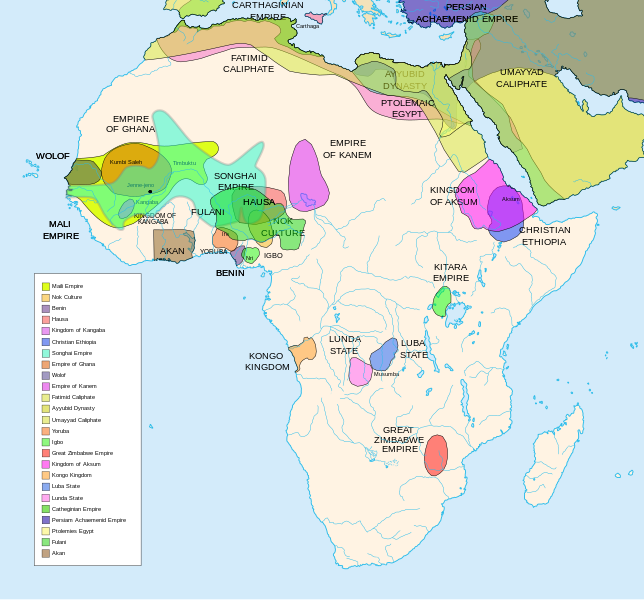
Diachronic map showing pre-colonial cultures of Africa (spanning roughly 500 BCE to 1500 CE)

This map is "an artistic interpretation" using multiple and disparate sources.
תאריך יצירה
מקור נוצר על־ידי מעלה היצירה
יוצר Jeff Israel (ZyMOS)
גרסאות אחרות

Derivative works of this file:  African-civilizations-map-imperial.png

Civilizations

These civilizations are shown on the map above

Mali Empire (done):
        [4], [5], [6], [7], [8](1300), 14

Nok Culture(done):
        http://perso.orange.fr/miltiade/Civilisation_de_Nok.htm
        [5]

Fulani empire (aka sokoto empire, Sokoto Calphate, Fulani Empire of Sokoto)  (fulani people are different) (done):
        [2], [10e], [11e]
Akan States (generric term for states with the akan people)(Done): 
 [7], 
Benin: (done)
        [7],[14],[16]
Hausa (done)
        [7], [10],[16]

Kingdon of Kangaba (1000AD?) (done)
        [8](1235)

Christian Ethiopia(done)
        [5]

Songhai Empire (done)
        http://commons.wikimedia.org/wiki/Image:Mapa_shonghai.svg
        [3], [4], [5], [6], [7], [8](1300), [16]
        http://www.zum.de/whkmla/histatlas/westafrica/haxmali.html
        http://empathosnationenterprises.com/Consulate/EN-Library/Black-Studies/afempire.html

Empire of Ghana (done):
        [4], [5], [6], [7]

Wolof: (15th century) (done)
        [2],[2c],[14]

Empire of Kanem:(done)
        [15]

Fatimid caliphate(done) 909-1171AD
        [2b],[6b]

Ayyubid dynasty (done) 1171-1250ad
        [1b], [5e], [6e]

Umayyad Caliphate (done) 661-750
        [5b]

Yoruba yorubaland    (done)
        [4b],[2c]

Igbo    (done)
        [4b],

Great Zimbabwe (done):
        [5], [7]

Kingdom of aksum (Axum?) 1bc-7ad  (done)
        [12b],[14b],[15b]

Kongo Kingdom     (done)
        [1c], [2c],[15]

Luba State (done) 15-19th century
        [2c],[4c]

Lunda State (done) 15-19th century
        [2c],[4c],[16]

Carthaginian Empire(done) (220BCE) Carthage
        [2c], [3c]

Persian Achaemenid Empire (done)
        [2e],3e].4e],[

THE PTOLEMIES (done)
        [8e], [9e]

Civilizations to be added

These civilizations have not been added because the borders have not yet been confirmed, or there is some uncertainty if they are a true civilization. Please add them to the map if you are able to define the borders of these civilizations.


Mane (1000-2000)(city) [41]

Kano (independent city-state) (1000-1903):
 [14]

Kaarta (kingdom of Kaarta) (1753-1854):
 [14]

Macina (Macina Empire) (aka Dina of Massina, Sise Jihad state, and Caliphate of Hamdullahi) (1818-1862):
 [14]

Segou (city 1620):
 [14]

Kingdom of Fouta Djallon (Futa Djalon or Kingdom of Fuuta Jallon):
 [14]

Hausa Bakwai (initial stage Hausa):
 [11e]

Wassoulou Empire (Ouassoulou) (1878 - 1898) :
 [14]

Kénédougou Kingdom (Kenedougou) (1650-1898):
 [14]

Ouagadougou (15th century CITY):
 [14]

Ashanti Kingdom:
	[14]

Dahomey:
	[14]

Gando (16th century town):
	[14]

kingdom of Takrur (c. 800 - c. 1285) :
	[8](1300), [13]

Oyo empire (1400-1796)


Bornu Empire (1396-1893):
        [2],[15], [10e]

Bornu-Kanem (a portion of kanem history where they merged):
	[7],[2c]

Wodaabe (a people of africa):
	[10]

Mamluk Sultanate of Egypt (1174-1820):
	[2],[12], 

Kush?Kushite kingdom?:

Axum (see kingdom of aksum):

Buganda kingdom (changed to Unganda, but remained as Buganda people):

Lozi???:

Malawi Empire (late 15th centure and converted to Malawi Contry):

Kilwa (Kilwa Kisiwani, 9th century,  is an Islamic community is present day tanzania):
	[2c]

Abyssinia???:
        [2], [7]

Soha????:
        [2],

Nubia (Makuria, Nobatia, Alodia kingdom):
	[7], 

Kingdom of Kerma(2500BC-1520BC):

=North Central=

Sahariano??:
	[1], 

Maban????????:
        [1],

Fur(a people:
        [1],

Sudanes Central (language Central Sudanic):
        [1],

=East Central=

Sudanes Meridional???:
        [1],

Berta(language>:
        [1],

Kunama(a people):
        [1],

Komuz???instument:
        [1],

Aksumite Civilization
	[7b], [9b(maybey], [13b(aksum)]

Kingdom of Sheva???
	[8b]

Egypt
	[10b]

JolofEmpire (also called Dyolof or Wolof), wolof should be changed to this:
	[11b]


Meroe(city, capital of Kushitic Kingdom)) 
	[12b]

Bantu(ethnic group)
	[12b]

Khoisan(ethnic group)
	[12b]

Almoravid Empire
	[5c], [1f]
	
Monomotapa
	[2c],[16]

Lozi
	[2c]

Zulu Kingdom
	[2c]

Merina
	[2c]

Malawi
	[2c]

Rawanda
	[2c]

Buganada
	[2c]

Kazembe
	[4c]


Punt (3000BC-1000BC):
	location lost in time

D'mt (800BC-100BC):


Gudit (1000AD):

Zagwe Dynasty (1000-1268AD):
	[6e]
	
Solomonic dynasty (1270-1974AD)

Himyar:
	[1d]

Qataban:
	[1d]

Saba:
	[1d]

Hadhramaut:
	[1d]

Thutmoses 1
	[1e]

Ramesses II
	[1e]

Assurbanipal, empire of 
	[7e]

Mbunda Kingdom
	[12e], [13e]

Editing this page and map

Suggestions before editing this map: Be sure to confirm it with multiple sources, and that it would be considered a true civilization. Also if you add to the map please name the layers and objects to keep it organized. A lot of the civilizations on this page do not have the times they existed. If this could be added it would be very beneficial. Then the map could be easily split into eras.

References

The original map came from


רישיון

אני, בעל זכויות היוצרים על היצירה הזאת, מפרסם אותה בזאת תחת הרישיונות הבאים:
GNU head מוענקת בכך הרשות להעתיק, להפיץ או לשנות את המסמך הזה, לפי תנאי הרישיון לשימוש חופשי במסמכים של גנו, גרסה 1.2 או כל גרסה מאוחרת יותר שתפורסם על־ידי המוסד לתוכנה חופשית; ללא פרקים קבועים, ללא טקסט עטיפה קדמית וללא טקסט עטיפה אחורית. עותק של הרישיון כלול בפרק שכותרתו הרישיון לשימוש חופשי במסמכים של גנו.
w:he:Creative Commons
ייחוס שיתוף זהה
הקובץ הזה מתפרסם לפי תנאי רישיונות קריאייטיב קומונז ייחוס-שיתוף זהה 3.0 לא מותאם, 2.5 כללי, 2.0 כללי ו־1.0 כללי.
הנכם רשאים:
  • לשתף – להעתיק, להפיץ ולהעביר את העבודה
  • לערבב בין עבודות – להתאים את העבודה
תחת התנאים הבאים:
  • ייחוס – יש לתת ייחוס הולם, לתת קישור לרישיון, ולציין אם נעשו שינויים. אפשר לעשות את זה בכל צורה סבירה, אבל לא בשום צורה שמשתמע ממנה שמעניק הרישיון תומך בך או בשימוש שלך.
  • שיתוף זהה – אם תיצרו רמיקס, תשנו, או תבנו על החומר, חובה עליכם להפיץ את התרומות שלך לפי תנאי רישיון זהה או תואם למקור.
הנכם מוזמנים לבחור את הרישיון הרצוי בעיניכם.

כיתובים

נא להוסיף משפט שמסביר מה הקובץ מייצג
Map of pre-colonial African civilizations

פריטים שמוצגים בקובץ הזה

מוצג

image/svg+xml

checksum אנגלית

458dcae2fb4eb4a66837ee9cd5c1e539750e7c18

הוגדר לפי: SHA-1 אנגלית

498,775 בית

1,295 פיקסל

1,390 פיקסל

היסטוריית הקובץ

ניתן ללחוץ על תאריך/שעה כדי לראות את הקובץ כפי שנראה באותו זמן.

(החדשות ביותר | הישנות ביותר) צפייה ב: (10 הבאות | ) (10 | 20 | 50 | 100 | 250 | 500)
תאריך/שעהתמונה ממוזערתממדיםמשתמשהערה
נוכחית09:49, 16 בפברואר 2024תמונה ממוזערת לגרסה מ־09:49, 16 בפברואר 2024‪1,295 × 1,390‬ (488 ק"ב)Ahiise2Changed "Bachwezi Empire" to "Kitara Empire" to be consistent with other versions of the file
07:11, 20 בספטמבר 2011תמונה ממוזערת לגרסה מ־07:11, 20 בספטמבר 2011‪1,295 × 1,390‬ (487 ק"ב)Alphathonmoved rivers to the top
06:33, 20 בספטמבר 2011תמונה ממוזערת לגרסה מ־06:33, 20 בספטמבר 2011‪1,295 × 1,390‬ (487 ק"ב)AlphathonOne more time…
06:27, 20 בספטמבר 2011תמונה ממוזערת לגרסה מ־06:27, 20 בספטמבר 2011‪1,295 × 1,390‬ (486 ק"ב)AlphathonFound some more errors
06:16, 20 בספטמבר 2011תמונה ממוזערת לגרסה מ־06:16, 20 בספטמבר 2011‪1,295 × 1,390‬ (489 ק"ב)AlphathonSome final clean-ups and fixes
05:59, 20 בספטמבר 2011תמונה ממוזערת לגרסה מ־05:59, 20 בספטמבר 2011‪1,295 × 1,390‬ (471 ק"ב)AlphathonApparently I duped The Persian Archaemenid Empire (now fixed). Also fixed borders of said empire.
05:50, 20 בספטמבר 2011תמונה ממוזערת לגרסה מ־05:50, 20 בספטמבר 2011‪1,295 × 1,390‬ (452 ק"ב)AlphathonReinstated "Akan" on proper vector version of the map and tidied up some sea-borders (some still need looking at)
05:02, 20 בספטמבר 2011תמונה ממוזערת לגרסה מ־05:02, 20 בספטמבר 2011‪1,295 × 1,390‬ (297 ק"ב)AlphathonReverted to version as of 22:11, 20 July 2010 - previous version was not a vector image
20:42, 26 במרץ 2011תמונה ממוזערת לגרסה מ־20:42, 26 במרץ 2011‪1,863 × 2,000‬ (2.66 מ"ב)Medicineman84== {{int:filedesc}} == {{Information |Description=Africa History Atlas Diachronic map showing pre-colonial cultures of Africa (spanning roughly 500 BCE to 1500 CE) This map is "an artistic interpretation" using multiple and disparate sources. |Source={
01:11, 21 ביולי 2010תמונה ממוזערת לגרסה מ־01:11, 21 ביולי 2010‪1,295 × 1,390‬ (297 ק"ב)Ras67font fault resolved
(החדשות ביותר | הישנות ביותר) צפייה ב: (10 הבאות | ) (10 | 20 | 50 | 100 | 250 | 500)

הדף הבא משתמש בקובץ הזה:

שימוש גלובלי בקובץ

אתרי הוויקי השונים הבאים משתמשים בקובץ זה:

צפו בשימושים בקובץ זה במיזמי ויקימדיה נוספים.

מטא־נתונים