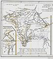
קובץ:AncientEgyptJamesRennell01.jpg

גודל התצוגה המקדימה הזאת: 541 × 599 פיקסלים. רזולוציות אחרות: 217 × 240 פיקסלים | 433 × 480 פיקסלים | 693 × 768 פיקסלים | 924 × 1,024 פיקסלים | 1,548 × 1,715 פיקסלים.
לקובץ המקורי (1,548 × 1,715 פיקסלים, גודל הקובץ: 384 ק"ב, סוג MIME: image/jpeg)
היסטוריית הקובץ
ניתן ללחוץ על תאריך/שעה כדי לראות את הקובץ כפי שנראה באותו זמן.
| תאריך/שעה | תמונה ממוזערת | ממדים | משתמש | הערה | |
|---|---|---|---|---|---|
| נוכחית | 22:23, 12 באוגוסט 2010 |  | 1,715 × 1,548 (384 ק"ב) | CarlDrews~commonswiki | {{Information |Description={{en|1=Map of ancient Egypt created by James Rennell as an insert for his book "The geographical system of Herodotus examined and explained" (published 1800 and 1830). This map shows Rennell's understanding of the geography of E |
שימוש בקובץ
הדף הבא משתמש בקובץ הזה:
שימוש גלובלי בקובץ
אתרי הוויקי השונים הבאים משתמשים בקובץ זה:
- שימוש באתר ar.wikipedia.org
- שימוש באתר bg.wikipedia.org
- שימוש באתר de.wikipedia.org
- שימוש באתר el.wikipedia.org
- שימוש באתר en.wikipedia.org
- שימוש באתר es.wikipedia.org
- שימוש באתר fr.wikipedia.org
- שימוש באתר ja.wikipedia.org
- שימוש באתר ja.wikibooks.org
- שימוש באתר nl.wikipedia.org
- שימוש באתר sl.wikipedia.org
- שימוש באתר uk.wikipedia.org
- שימוש באתר zh.wikipedia.org
