
קובץ:AnzioCassino1944May.jpg
גודל התצוגה המקדימה הזאת: 785 × 599 פיקסלים. רזולוציות אחרות: 314 × 240 פיקסלים | 629 × 480 פיקסלים | 1,006 × 768 פיקסלים | 1,265 × 966 פיקסלים.
לקובץ המקורי (1,265 × 966 פיקסלים, גודל הקובץ: 917 ק"ב, סוג MIME: image/jpeg)
| זהו קובץ שמקורו במיזם ויקישיתוף. תיאורו בדף תיאור הקובץ המקורי (בעברית) מוצג למטה. |
תקציר
| תיאור |
Dansk: Det allierede udbrud fra Anzio og fremrykningen fra Gustavlinjen i maj 1944.
Deutsch: Ausbruch aus dem Brückenkopf und Operation Diadem, Mai 1944.
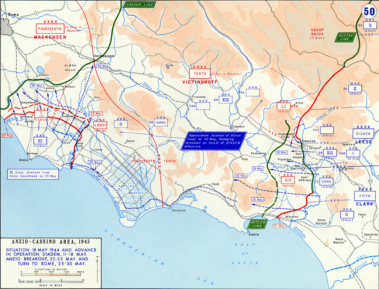
English: The Allied breakout from Anzio and advance from the Gustav Line May 1944. Area of operations, late May 1944.
日本語: 連合軍のアンツィオ包囲網突破とグスタフ・ラインからの進撃 1944年5月.
Русский: Наступление союзников под Монте-Кассино (операция «Диадема») и прорыв союзников с плацдарма в Анцио, май 1944.
中文:1944年5月從安濟奧突破及通過之古斯塔夫防線前進之盟軍進攻路線圖. |
| מקור | http://www.military.com/Resources/ResourceFileView?file=worldwarii_europe_maps_map50.htm |
| יוצר |
רישיון
This work is in the public domain in the United States because it is a work prepared by an officer or employee of the United States Government as part of that person’s official duties under the terms of Title 17, Chapter 1, Section 105 of the US Code.
Note: This only applies to original works of the Federal Government and not to the work of any individual U.S. state, territory, commonwealth, county, municipality, or any other subdivision. This template also does not apply to postage stamp designs published by the United States Postal Service since 1978. (See § 313.6(C)(1) of Compendium of U.S. Copyright Office Practices). It also does not apply to certain US coins; see The US Mint Terms of Use.
|
 | |
| הקובץ הזה זוהה כקובץ חופשי מכל מגבלה ידועה תחת חוק זכויות היוצרים, כולל כל הזכויות הקשורות והסמוכות. | ||
היסטוריית הקובץ
ניתן ללחוץ על תאריך/שעה כדי לראות את הקובץ כפי שנראה באותו זמן.
| תאריך/שעה | תמונה ממוזערת | ממדים | משתמש | הערה | |
|---|---|---|---|---|---|
| נוכחית | 23:38, 11 במרץ 2007 | | 966 × 1,265 (917 ק"ב) | Kirrages | {{Information |Description= |Source=http://www.military.com/Resources/ResourceFileView?file=worldwarii_europe_maps_map50.htm |Date= |Author= |Permission= |other_versions= }} |
שימוש בקובץ
הדף הבא משתמש בקובץ הזה:
שימוש גלובלי בקובץ
אתרי הוויקי השונים הבאים משתמשים בקובץ זה:
- שימוש באתר azb.wikipedia.org
- שימוש באתר bg.wikipedia.org
- שימוש באתר da.wikipedia.org
- שימוש באתר de.wikipedia.org
- שימוש באתר en.wikipedia.org
- שימוש באתר it.wikipedia.org
- שימוש באתר ja.wikipedia.org
- שימוש באתר nl.wikipedia.org
- שימוש באתר ru.wikipedia.org
- שימוש באתר simple.wikipedia.org
- שימוש באתר sk.wikipedia.org
- שימוש באתר tr.wikipedia.org
- שימוש באתר uk.wikipedia.org
- שימוש באתר www.wikidata.org
- שימוש באתר zh.wikipedia.org