
קובץ:Bermeja.jpg

לקובץ המקורי (2,192 × 1,512 פיקסלים, גודל הקובץ: 2.79 מ"ב, סוג MIME: image/jpeg)
| זהו קובץ שמקורו במיזם ויקישיתוף. תיאורו בדף תיאור הקובץ המקורי (בעברית) מוצג למטה. |
תקציר
| תיאור |
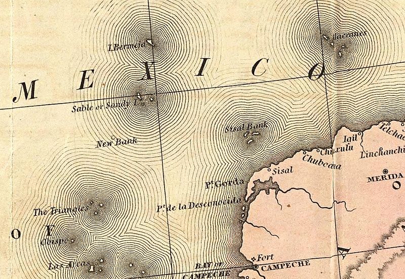
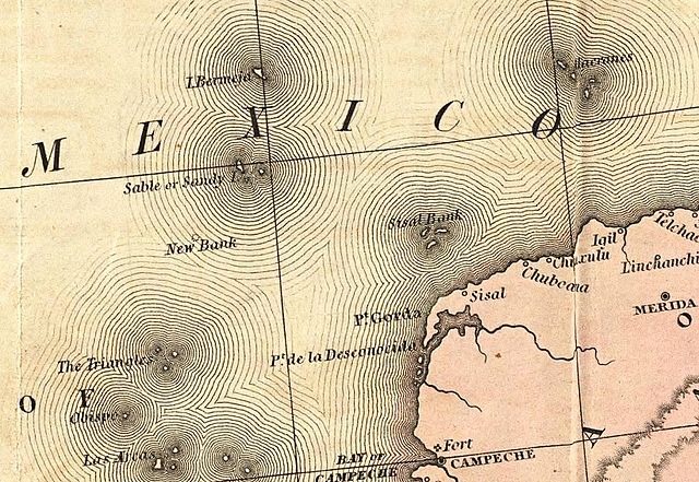
English: Old map showing the Mexican phantom island Bermeja. |
| תאריך יצירה | |
| מקור | A Map of the United States of Mexico, 3rd ed. |
| יוצר | Tanner, Henry S. |
רישיון
|
יצירה זו נמצאת בנחלת הכלל במדינת המקור ובמדינות אחרות בהם תקופת זכויות היוצרים היא משך חיי היוצר ו-70 שנה (או פחות) מפטירתו.
| |
| הקובץ הזה זוהה כקובץ חופשי מכל מגבלה ידועה תחת חוק זכויות היוצרים, כולל כל הזכויות הקשורות והסמוכות. | |
היסטוריית הקובץ
ניתן ללחוץ על תאריך/שעה כדי לראות את הקובץ כפי שנראה באותו זמן.
| תאריך/שעה | תמונה ממוזערת | ממדים | משתמש | הערה | |
|---|---|---|---|---|---|
| נוכחית | 13:14, 29 ביולי 2016 | | 1,512 × 2,192 (2.79 מ"ב) | Themadchopper | larger |
| 04:24, 13 במרץ 2009 |  | 378 × 548 (97 ק"ב) | Gabagool | {{Information |Description={{en|1=Old map showing the Mexican phantom island Bermeja.}} |Source=[http://www.davidrumsey.com/luna/servlet/detail/RUMSEY~8~1~218~20035:A-Map-Of-The-United-States-Of-Mexico] |Author=Tanner, Henry S. |Date=1846 |Permission= |ot |
שימוש בקובץ
הדף הבא משתמש בקובץ הזה:
שימוש גלובלי בקובץ
אתרי הוויקי השונים הבאים משתמשים בקובץ זה:
- שימוש באתר ca.wikipedia.org
- שימוש באתר ceb.wikipedia.org
- שימוש באתר de.wikipedia.org
- שימוש באתר en.wikipedia.org
- שימוש באתר eo.wikipedia.org
- שימוש באתר es.wikipedia.org
- שימוש באתר fr.wikipedia.org
- שימוש באתר hu.wikipedia.org
- שימוש באתר id.wikipedia.org
- שימוש באתר it.wikipedia.org
- שימוש באתר ja.wikipedia.org
- שימוש באתר ko.wikipedia.org
- שימוש באתר pl.wikipedia.org
- שימוש באתר ru.wikipedia.org
- שימוש באתר sv.wikipedia.org
- שימוש באתר uk.wikipedia.org
- שימוש באתר www.wikidata.org