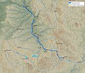
קובץ:Main-Donau-Kanal-Karte.jpg
מראה

גודל התצוגה המקדימה הזאת: 702 × 600 פיקסלים. רזולוציות אחרות: 281 × 240 פיקסלים | 562 × 480 פיקסלים | 899 × 768 פיקסלים | 1,198 × 1,024 פיקסלים | 1,280 × 1,094 פיקסלים.
לקובץ המקורי (1,280 × 1,094 פיקסלים, גודל הקובץ: 202 ק"ב, סוג MIME: image/jpeg)
היסטוריית הקובץ
ניתן ללחוץ על תאריך/שעה כדי לראות את הקובץ כפי שנראה באותו זמן.
| תאריך/שעה | תמונה ממוזערת | ממדים | משתמש | הערה | |
|---|---|---|---|---|---|
| נוכחית | 20:53, 18 ביוני 2009 |  | 1,094 × 1,280 (202 ק"ב) | Jailbird | Maßstabsleiste hinzugefügt |
| 15:47, 22 בינואר 2007 |  | 1,094 × 1,280 (200 ק"ב) | Jailbird | *Karte des Main-Donau-Kanals zwischen Main (Bamberg) und Donau (Kelheim). Das Bild wurde von mir am 19.1.2007 selbst erstellt. Das Hintergrundbild wurde mit den Generic Mapping Tools (GMT, http://gmt.soest.hawaii.edu) unter Verwen |
שימוש בקובץ
הדף הבא משתמש בקובץ הזה:
שימוש גלובלי בקובץ
אתרי הוויקי השונים הבאים משתמשים בקובץ זה:
- שימוש באתר bg.wikipedia.org
- שימוש באתר bs.wikipedia.org
- שימוש באתר cs.wikipedia.org
- שימוש באתר da.wikipedia.org
- שימוש באתר de.wikipedia.org
- שימוש באתר de.wikisource.org
- שימוש באתר de.wikiversity.org
- שימוש באתר el.wikipedia.org
- שימוש באתר en.wikipedia.org
- שימוש באתר eo.wikipedia.org
- שימוש באתר es.wikipedia.org
- שימוש באתר et.wikipedia.org
- שימוש באתר fi.wikipedia.org
- שימוש באתר hr.wikipedia.org
- שימוש באתר hu.wikipedia.org
- שימוש באתר id.wikipedia.org
- שימוש באתר ja.wikipedia.org
- שימוש באתר jv.wikipedia.org
- שימוש באתר ko.wikipedia.org
- שימוש באתר lo.wikipedia.org
- שימוש באתר lt.wikipedia.org
- שימוש באתר ms.wikipedia.org
- שימוש באתר nl.wikipedia.org
- שימוש באתר pt.wikipedia.org
- שימוש באתר ru.wikipedia.org
- שימוש באתר sh.wikipedia.org
- שימוש באתר sk.wikipedia.org
- שימוש באתר sl.wikipedia.org
- שימוש באתר sv.wikipedia.org
- שימוש באתר uk.wikipedia.org
- שימוש באתר www.wikidata.org
- שימוש באתר zh.wikipedia.org


