
קובץ:NASA Wallops Flight Facility, 2010.jpg
לקובץ המקורי (1,024 × 683 פיקסלים, גודל הקובץ: 557 ק"ב, סוג MIME: image/jpeg)
| זהו קובץ שמקורו במיזם ויקישיתוף. תיאורו בדף תיאור הקובץ המקורי (בעברית) מוצג למטה. |
תקציר
| תיאור |
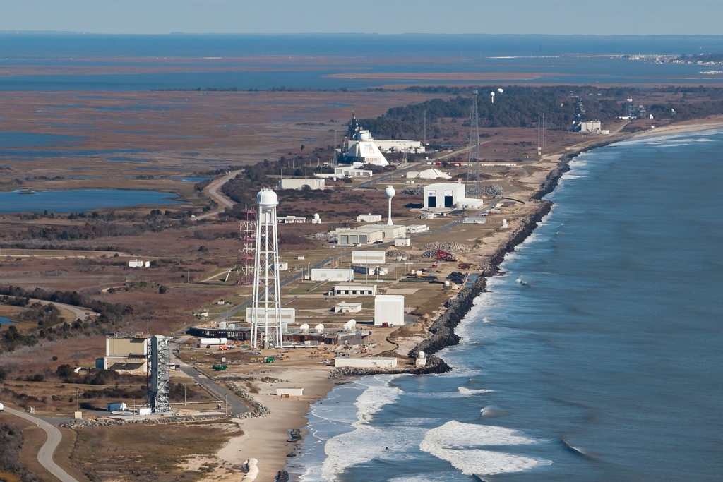
English: NASA Goddard Space Flight Center's Wallops Flight Facility, located on Virginia's Eastern Shore, was established in 1945 by the National Advisory Committee for Aeronautics, as a center for aeronautic research.
Wallops is now NASA's principal facility for management and implementation of suborbital research programs. The Wallops Mission Plan includes the following objectives: • To help achieve NASA's strategic objectives for scientific and educational excellence through cost efficient integration, launch, and operations of suborbital and small orbital payloads. • To enable scientific, educational, and economic advancement by providing the facilities and expertise to enable frequent flight opportunities for a diverse customer base. • To serve as a key facility for operational test, integration, and certification of NASA and commercial next-generation, low-cost orbital launch technologies. • To pioneer productive and innovative government, industry, and academic partnerships. The research and responsibilities of Wallops Flight Facility are centered around the philosophy of providing a fast, low cost, highly flexible and safe response to meet the needs of the United States' aerospace technology interests and science research. The 1,000 full-time Civil Service and contractor NASA Wallops employees act as a team to accomplish our mission in the spirit of this philosophy. NASA also opens its unique facilities to industry for space and aeronautics research. Wallops expects an increase in commercial launch activity in the very near future. |
| תאריך יצירה | |
| מקור | NASA Wallops Flight Facility |
| יוצר | NASA/Wallops Flight Facility |
| מיקום המצלמה | | תמונה זו ותמונות נוספות במיקום: OpenStreetMap |
|---|
רישיון
| קובץ זה נמצא ברשות הציבור מכיוון שהוא נוצר על ידי נאס"א. מדיניות זכויות היוצרים של נאס"א קובעת ש"חומרים של NASA אינם מוגנים בזכויות יוצרים אלא אם צוין אחרת". (דף מדיניות זכויות היוצרים ב-NASA או מדיניות שימוש בתמונות ב-JPL). | ||
 |
אזהרות:
|
היסטוריית הקובץ
ניתן ללחוץ על תאריך/שעה כדי לראות את הקובץ כפי שנראה באותו זמן.
| תאריך/שעה | תמונה ממוזערת | ממדים | משתמש | הערה | |
|---|---|---|---|---|---|
| נוכחית | 23:41, 31 באוגוסט 2011 | | 683 × 1,024 (557 ק"ב) | File Upload Bot (Magnus Manske) | {{Information |Description=NASA Goddard Space Flight Center's Wallops Flight Facility, located on Virginia's Eastern Shore, was established in 1945 by the National Advisory Committee for Aeronautics, as a center for aeronautic research. Wallops is now N |
שימוש בקובץ
הדף הבא משתמש בקובץ הזה:
שימוש גלובלי בקובץ
אתרי הוויקי השונים הבאים משתמשים בקובץ זה:
- שימוש באתר ca.wikipedia.org
- שימוש באתר ceb.wikipedia.org
- שימוש באתר en.wikipedia.org
- שימוש באתר eo.wikipedia.org
- שימוש באתר fa.wikipedia.org
- שימוש באתר fi.wikipedia.org
- שימוש באתר gl.wikipedia.org
- שימוש באתר it.wikipedia.org
- שימוש באתר ja.wikipedia.org
- שימוש באתר pt.wikipedia.org
- שימוש באתר ru.wikipedia.org
- שימוש באתר sk.wikipedia.org
- שימוש באתר uk.wikipedia.org
- שימוש באתר www.wikidata.org