
קובץ:NYTMap2ndBattleOfYpres1915.png
NYTMap2ndBattleOfYpres1915.png (480 × 571 פיקסלים, גודל הקובץ: 69 ק"ב, סוג MIME: image/png)
| זהו קובץ שמקורו במיזם ויקישיתוף. תיאורו בדף תיאור הקובץ המקורי (בעברית) מוצג למטה. |
| תיאור |
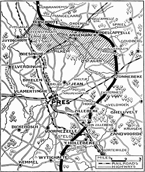
"Current History" (New York Times) map showing reported positions during the Second Battle of Ypres, as at about 30 April 1915. On 1 May the British withdrew to shorten their lines, with the final front line running through Hooge, Frenzenberg (not shown, but 1 3/4 mile sw of Zonnebeke) and west to Mouse Trap farm and Turco farms (not shown, but 1 mile sw of St Julien).
NYT caption : "The German rush across the Yser-Ypres Canal was checked at Lizerne and opposite Boesinghe. The shaded area on the map marks the scene of the battle. Within this area are Steenstraate, Het Sast, Pilkem, St. Julien, and Langemarck, all of which the Germans claimed to have captured." |
| תאריך יצירה | |
| מקור |
New York Times Current History. The European War, Vol. 2 No. 3, June 1915. Downloaded from http://www.gutenberg.org/ebooks/15480 |
| יוצר | "Current History" (New York Times) |
קובץ מדיה זה נמצא ברשות הציבור בארצות הברית. זה תקף לעבודות אמריקניות שבהן זכויות היוצרים פגו, לעתים מסיבה שהפרסום הראשון היה לפני 1 בינואר 1929. ראו דף זה להסבר נוסף.
|
 | |
 |
תמונה זו עשויה שלא להיות תחת רשות הציבור מחוץ לארצות הברית (זה נכון במיוחד במדינות ובאזורים שבהם לא חל rule of the shorter term עבור יצירות אמריקניות, ובהן קנדה, סין היבשתית (לא כולל הונג קונג ומקאו), גרמניה, מקסיקו, ושוויץ). היוצר ושנת הפרסום הם מידע חיוני שחובה לציין. ראו הסבר על רשות הציבור וזכויות יוצרים למידע נוסף.
|
היסטוריית הקובץ
ניתן ללחוץ על תאריך/שעה כדי לראות את הקובץ כפי שנראה באותו זמן.
| תאריך/שעה | תמונה ממוזערת | ממדים | משתמש | הערה | |
|---|---|---|---|---|---|
| נוכחית | 13:26, 13 בפברואר 2008 | | 571 × 480 (69 ק"ב) | Rcbutcher | {{Information |Description=New York Times map showing reported positions after the Second Battle of Ypres, April - May 1915. <br>NYT caption : "The German rush across the Yser-Ypres Canal was checked at Lizerne and opposite Boesinghe. The shaded area on t |
שימוש בקובץ
הדף הבא משתמש בקובץ הזה:
שימוש גלובלי בקובץ
אתרי הוויקי השונים הבאים משתמשים בקובץ זה:
- שימוש באתר de.wikipedia.org
- שימוש באתר en.wikipedia.org
- שימוש באתר es.wikipedia.org
- שימוש באתר fr.wikipedia.org
- שימוש באתר it.wikipedia.org
- שימוש באתר nl.wikipedia.org