
קובץ:Satellite image map of Mayak.jpg

גודל התצוגה המקדימה הזאת: 800 × 509 פיקסלים. רזולוציות אחרות: 320 × 204 פיקסלים | 640 × 408 פיקסלים | 1,024 × 652 פיקסלים | 1,448 × 922 פיקסלים.
לקובץ המקורי (1,448 × 922 פיקסלים, גודל הקובץ: 290 ק"ב, סוג MIME: image/jpeg)
| זהו קובץ שמקורו במיזם ויקישיתוף. תיאורו בדף תיאור הקובץ המקורי (בעברית) מוצג למטה. |
| תיאור |
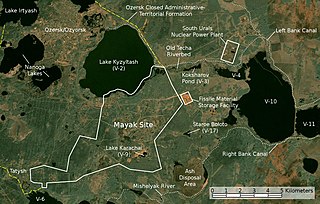
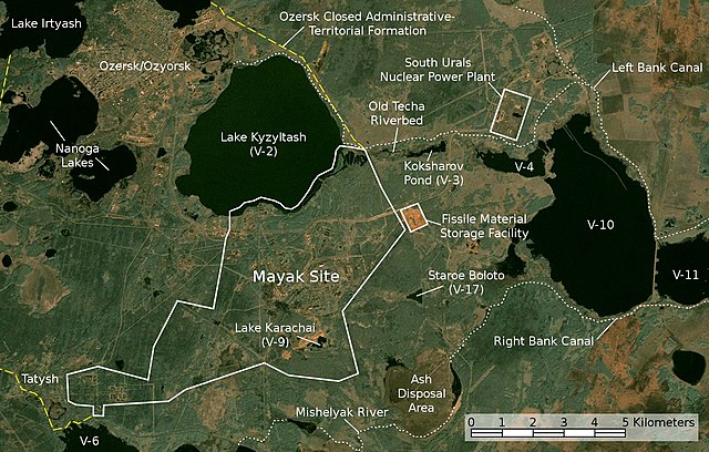
English: Satellite image/map of the Mayak nuclear facility, the closed town of Ozyorsk/Ozersk (Chelyabinsk-65), different lakes and reservoirs, and the South Urals nuclear power plant.
Based on a screenshot from NASA World Wind (Landsat Global Mosaic visual layer), color corrected.
Deutsch: Satellitenfoto/Karte der kerntechnischen Anlage Majak, der geschlossenen Stadt Osjorsk (Tscheljabinsk-65), verschiedenen Seen und Reservoirs sowie dem Kernkraftwerk Süd-Ural.
Basierend auf einem Screenshot aus NASA World Wind (Landsat Global Mosaic visual layer), farbkorrigiert. |
|||||
| תאריך יצירה | ||||||
| מקור | NASA World Wind screenshot (Landsat Global Mosaic visual layer) | |||||
| יוצר | NASA, Jan Rieke (color correction, borders and labels) | |||||
| אישורים והיתרים (שימוש חוזר בקובץ זה) |
|
|||||
| גרסאות אחרות | File:Majak Satellitenkarte.jpg |

| זוהי תמונה מרוטשת, זאת אומרת שהתמונה שונתה בצורה דיגיטלית מהמקור. Modifications: color correction, labeling. השינוי בוצע על ידי JanRieke.
|
| מיקום המצלמה | | תמונה זו ותמונות נוספות במיקום: OpenStreetMap |
|---|
Credit appreciated when reusing this image.
Sources
Primary Sources
- Igor Kudrik, Aleksandr Nikitin, Charles Digges, Nils Bøhmer, Vladislav Larin, Vladimir Kuznetsov: The Russian Nuclear Industry – The Need for Reform. Bellona Report Volume 4:2004. Bellona Foundation, pp. 47–69, November 1, 2004
- Map of the system of dams and drainage channels at Mayak., in: AMAP Assessment Report: Arctic Pollution Issues, Arctic Monitoring & Assessment Programme, Working Group of the Arctic Council, 1998
- Dmitriy Burmistrov, Mira Kossenko, Richard Wilson: Radioactive Contamination of the Techa River and its Effects. archive copy at the Wayback Machine Technology, Vol. 7, pp. 553-575, 2000
Secondary Sources
Location of V-6
- B. Gusakov, A. Demin, M. Zawadzki, V. Kalinkin, A. Kirsanov, N. Shafrova: Решение экологических проблем Теченского каскада водоемов на ПО "Маяк"., December 19, 2006
Ash Disposal Area
- A. R. Hutter: Radioactive contamination distribution in the bottom sediments and water of the Mishelyak River[dead link], Journal of Radioanalytical and Nuclear Chemistry, 2001
- O. Aleksandrova: Natural remediation of surface water systems used as deposits of nuclear industry waste by humic substances, Dissertation, University of Osnabrück, 2009
היסטוריית הקובץ
ניתן ללחוץ על תאריך/שעה כדי לראות את הקובץ כפי שנראה באותו זמן.
| תאריך/שעה | תמונה ממוזערת | ממדים | משתמש | הערה | |
|---|---|---|---|---|---|
| נוכחית | 06:45, 28 בנובמבר 2010 | | 922 × 1,448 (290 ק"ב) | JanRieke | included courses of rivers, yellow color for closed city borders, slightly reduced brightness, minor other changes |
| 01:12, 15 במאי 2010 |  | 922 × 1,448 (275 ק"ב) | JanRieke | label for Mishelyak River, removed name of V-4 due to contradictory sources | |
| 06:00, 9 במאי 2010 |  | 922 × 1,448 (275 ק"ב) | JanRieke | Minor improvements: alternative spelling of Ozersk "Ozyorsk", incr. font size for Mayak, ash disposal area, transparency for scale | |
| 02:44, 1 במאי 2010 |  | 922 × 1,448 (272 ק"ב) | JanRieke | {{Information |Description={{en|1=Satellite image/map of the Mayak nuclear facility, the closed town of Ozersk (Chelyabinsk-65), different lakes and reservoirs, and the South Urals nuclear power plant. Based on a screenshot from NASA World Wind (Landsat G |
שימוש בקובץ
הדף הבא משתמש בקובץ הזה:
שימוש גלובלי בקובץ
אתרי הוויקי השונים הבאים משתמשים בקובץ זה:
- שימוש באתר ar.wikipedia.org
- שימוש באתר cs.wikipedia.org
- שימוש באתר da.wikipedia.org
- שימוש באתר de.wikipedia.org
- שימוש באתר en.wikipedia.org
- שימוש באתר eu.wikipedia.org
- שימוש באתר fa.wikipedia.org
- שימוש באתר fi.wikipedia.org
- שימוש באתר fr.wikipedia.org
- שימוש באתר hr.wikipedia.org
- שימוש באתר hu.wikipedia.org
- שימוש באתר ig.wikipedia.org
- שימוש באתר it.wikipedia.org
- שימוש באתר ja.wikipedia.org
- שימוש באתר ko.wikipedia.org
- שימוש באתר mk.wikipedia.org
- שימוש באתר nl.wikipedia.org
- שימוש באתר nn.wikipedia.org
- שימוש באתר pl.wikipedia.org
- שימוש באתר pt.wikipedia.org
- שימוש באתר ru.wikipedia.org
- שימוש באתר simple.wikipedia.org
- שימוש באתר sk.wikipedia.org
- שימוש באתר sr.wikipedia.org
- שימוש באתר sv.wikipedia.org
- שימוש באתר vi.wikipedia.org
- שימוש באתר zh.wikipedia.org