
קובץ:United Kingdom ESA361630.tiff

לקובץ המקורי (4,000 × 3,496 פיקסלים, גודל הקובץ: 80.04 מ"ב, סוג MIME: image/tiff)
| זהו קובץ שמקורו במיזם ויקישיתוף. תיאורו בדף תיאור הקובץ המקורי (בעברית) מוצג למטה. |
תקציר
| תיאור |
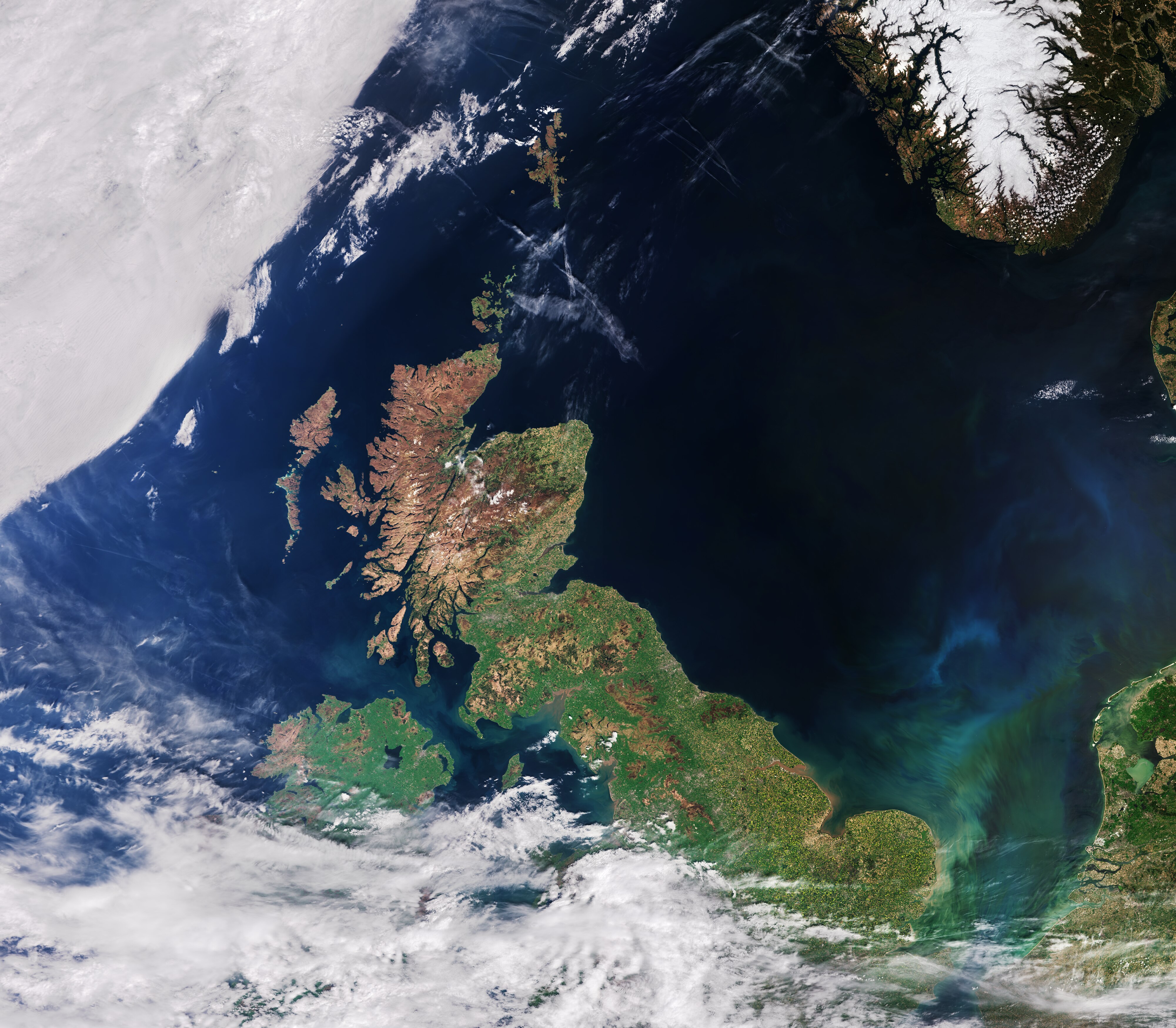
English: The recently launched Sentinel-3A satellite takes us over the United Kingdom, in this false-colour image acquired on 9 May.
Made up of England, Scotland, Wales and Northern Ireland, the UK is an island nation in northwestern Europe. At the top centre of the image, we can see aircraft contrails – water vapour condenses around the small particles in the aircraft exhaust to form ice crystals. The result is the formation of an elongated cloud-like condensation trail in the sky, unmistakable in the centre of the image. At top right, some snow cover in southern Norway is still evident. At bottom right, part of the Netherlands with the unmistakable 700 sq km Lake Markermeer is clearly visible. In the southern North Sea/English Channel, an algal bloom is distinguishable in shades of light blue and green. Meanwhile, closer to the coast we can see brown sediments where rivers and streams run into the sea. The Scottish Highlands at the tip of the United Kingdom appear light brown, representing bare soil and rock formations, with some vegetation. The rest of the island, as well as the visible part of Ireland, are very green, representing dense vegetation. Sentinel-3A’s Ocean and Land Colour Instrument is a new eye on Earth, monitoring ocean ecosystems, supporting crop management and agriculture, and providing estimates of atmospheric aerosol and clouds – all of which will bring significant benefits to society through more informed decision-making. This image is also featured on the Earth from Space video programme. |
| תאריך יצירה | |
| מקור | http://www.esa.int/spaceinimages/Images/2016/06/United_Kingdom |
| יוצר | European Space Agency |
| אישורים והיתרים (שימוש חוזר בקובץ זה) |
Contains modified Copernicus Sentinel data [2016]/ processed by ESA,CC BY-SA 3.0 IGO |
| גרסאות אחרות |
|
| Title | United Kingdom |
| Location | United Kingdom |
| Set | Earth observation image of the week |
| Mission | Sentinel-3 |
| Activity | Observing the Earth |

רישיון
- הנכם רשאים:
- לשתף – להעתיק, להפיץ ולהעביר את העבודה
- לערבב בין עבודות – להתאים את העבודה
- תחת התנאים הבאים:
- ייחוס – יש לתת ייחוס הולם, לתת קישור לרישיון, ולציין אם נעשו שינויים. אפשר לעשות את זה בכל צורה סבירה, אבל לא בשום צורה שמשתמע ממנה שמעניק הרישיון תומך בך או בשימוש שלך.
- שיתוף זהה – אם תיצרו רמיקס, תשנו, או תבנו על החומר, חובה עליכם להפיץ את התרומות שלך לפי תנאי רישיון זהה או תואם למקור.
היסטוריית הקובץ
ניתן ללחוץ על תאריך/שעה כדי לראות את הקובץ כפי שנראה באותו זמן.
| תאריך/שעה | תמונה ממוזערת | ממדים | משתמש | הערה | |
|---|---|---|---|---|---|
| נוכחית | 17:45, 6 במאי 2017 |  | 3,496 × 4,000 (80.04 מ"ב) | Fæ | == {{int:filedesc}} == {{information | description = {{en|1=The recently launched Sentinel-3A satellite takes us over the United Kingdom, in this false-colour image acquired on 9 May. Made up of England, Scotland, Wales and Northern Ireland, the UK is... |
שימוש בקובץ
הדף הבא משתמש בקובץ הזה:
שימוש גלובלי בקובץ
אתרי הוויקי השונים הבאים משתמשים בקובץ זה:
- שימוש באתר en.wikipedia.org
- שימוש באתר es.wikipedia.org
- שימוש באתר fa.wikipedia.org
- שימוש באתר www.wikidata.org