
קובץ:Venezuela Division Politica Territorial.svg

גודל התצוגה המקדימה הזאת מסוג PNG של קובץ ה־SVG הזה: 781 × 600 פיקסלים. רזולוציות אחרות: 313 × 240 פיקסלים | 625 × 480 פיקסלים | 1,000 × 768 פיקסלים | 1,280 × 983 פיקסלים | 2,560 × 1,966 פיקסלים | 2,121 × 1,629 פיקסלים.
לקובץ המקורי (קובץ SVG, הגודל המקורי: 2,121 × 1,629 פיקסלים, גודל הקובץ: 141 ק"ב)
| זהו קובץ שמקורו במיזם ויקישיתוף. תיאורו בדף תיאור הקובץ המקורי (בעברית) מוצג למטה. |
| תיאור |
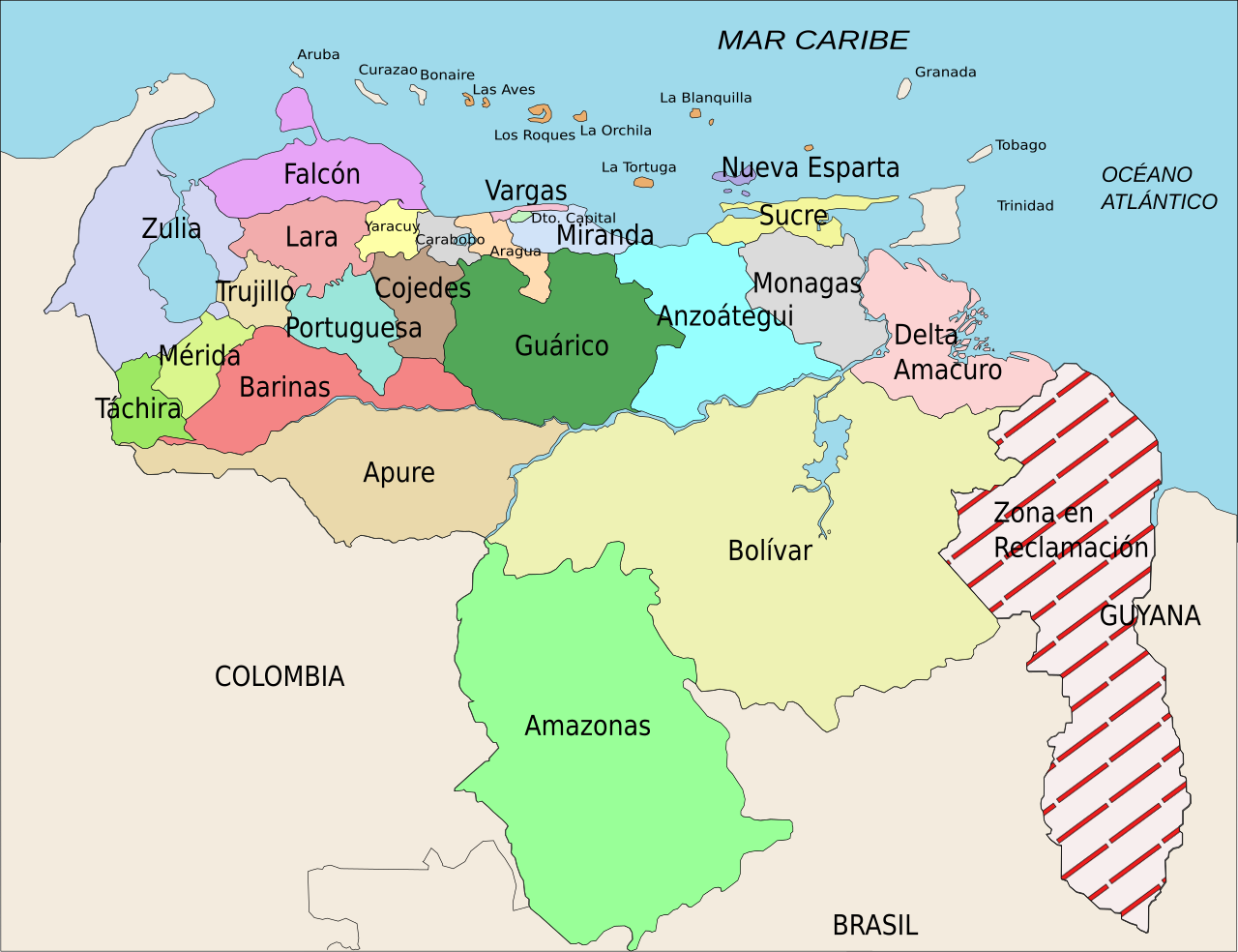
Español: División Político Territorial de Venezuela. Es un mapa acerca de los estados de Venezuela o división político territorial. La zona en reclamación aun no se sabe si pertenece a Guyana o a Venezuela, por eso se suele colocar de esa manera.
English: Political divisions of Venezuela. The Reclamation zone is Guyanan territory claimed by Venezuela. |
| תאריך יצירה | |
| מקור | self work, Image:Venezuela politica copy.png based |
| יוצר | Wilfredor |
| אישורים והיתרים (שימוש חוזר בקובץ זה) |
Own work, copyleft: Multi-license with GFDL and Creative Commons CC-BY-SA-2.5 and older versions (2.0 and 1.0) |
| גרסאות אחרות |
Derivative works of this file: Venezuela Division Politica Territorial mk.svg
[]
|


. Inkscape עם נוצרה ה תמונה
אני, בעל זכויות היוצרים על היצירה הזאת, מפרסם אותה בזאת תחת הרישיונות הבאים:

|
מוענקת בכך הרשות להעתיק, להפיץ או לשנות את המסמך הזה, לפי תנאי הרישיון לשימוש חופשי במסמכים של גנו, גרסה 1.2 או כל גרסה מאוחרת יותר שתפורסם על־ידי המוסד לתוכנה חופשית; ללא פרקים קבועים, ללא טקסט עטיפה קדמית וללא טקסט עטיפה אחורית. עותק של הרישיון כלול בפרק שכותרתו הרישיון לשימוש חופשי במסמכים של גנו. |
| הקובץ הזה מתפרסם לפי תנאי רישיון קריאייטיב קומונז ייחוס-שיתוף זהה 3.0 לא מותאם. | ||
| ||
| תבנית רישוי זו הוספה לקובץ כחלק מעדכון רישיון GFDL. |
- הנכם רשאים:
- לשתף – להעתיק, להפיץ ולהעביר את העבודה
- לערבב בין עבודות – להתאים את העבודה
- תחת התנאים הבאים:
- ייחוס – יש לתת ייחוס הולם, לתת קישור לרישיון, ולציין אם נעשו שינויים. אפשר לעשות את זה בכל צורה סבירה, אבל לא בשום צורה שמשתמע ממנה שמעניק הרישיון תומך בך או בשימוש שלך.
- שיתוף זהה – אם תיצרו רמיקס, תשנו, או תבנו על החומר, חובה עליכם להפיץ את התרומות שלך לפי תנאי רישיון זהה או תואם למקור.
הנכם מוזמנים לבחור את הרישיון הרצוי בעיניכם.
היסטוריית הקובץ
ניתן ללחוץ על תאריך/שעה כדי לראות את הקובץ כפי שנראה באותו זמן.
| תאריך/שעה | תמונה ממוזערת | ממדים | משתמש | הערה | |
|---|---|---|---|---|---|
| נוכחית | 00:00, 17 באפריל 2008 | | 1,629 × 2,121 (141 ק"ב) | Wilfredor | {{Information |Description= '''(Spanish):''' División Político Territorial de Venezuela. Es un mapa acerca de los estados de Venezuela o división político territorial. La zona en reclamación aun no se sabe si pertenece a Guyana o a Venezuela, por es |
| 18:17, 21 באפריל 2007 |  | 1,629 × 2,121 (140 ק"ב) | Wilfredor | {{Information |Description= '''(Spanish):''' División Político Territorial de Venezuela. Es un mapa acerca de los estados de Venezuela o división político territorial. La zona en reclamación aun no se sabe si pertenece a Guyana o a Venezuela, por es | |
| 00:11, 20 באפריל 2007 |  | 1,629 × 2,121 (135 ק"ב) | Spundun | Reverted to earlier revision | |
| 00:10, 20 באפריל 2007 |  | 1,629 × 2,119 (135 ק"ב) | Spundun | Reverted to earlier revision | |
| 17:52, 19 באפריל 2007 |  | 1,629 × 2,121 (135 ק"ב) | Wilfredor | {{Information |Description= '''(Spanish):''' División Político Territorial de Venezuela </br> '''(English):''' Politic Territorial Division of Venezuela |Source=self work, Image:Venezuela politica copy.png based |Date=2007 |Author=[[user:wilfredo | |
| 03:33, 18 באפריל 2007 |  | 1,629 × 2,119 (135 ק"ב) | Wilfredor | {{Information |Description= '''(Spanish):''' División Político Territorial de Venezuela </br> '''(English):''' Politic Territorial Division of Venezuela |Source=self work |Date=2007 |Author=Wilfredo R. Rodriguez H. |Permission=Own wo | |
| 02:55, 18 באפריל 2007 |  | 1,629 × 2,119 (124 ק"ב) | Wilfredor | {{Information |Description= '''(Spanish):''' División Político Territorial de Venezuela </br> '''(English):''' Politic Territorial Division of Venezuela |Source=self work |Date=2007 |Author=Wilfredo R. Rodriguez H. |Permission=Own wo | |
| 23:56, 17 באפריל 2007 |  | 1,664 × 2,160 (107 ק"ב) | Wilfredor | {{Information |Description= '''(Spanish):''' División Político Territorial de Venezuela </br> '''(English):''' Politic Territorial Division of Venezuela |Source=self work |Date=2007 |Author=Wilfredo R. Rodriguez H. |Permission=Own wo | |
| 16:30, 17 באפריל 2007 |  | 1,664 × 2,160 (88 ק"ב) | Wilfredor | {{Information |Description= '''(Spanish):''' División Político Territorial de Venezuela </br> '''(English):''' Politic Territorial Division of Venezuela |Source=self work |Date=2007 |Author=Wilfredo R. Rodriguez H. |Permission=Own wo | |
| 05:54, 17 באפריל 2007 |  | 1,664 × 2,160 (83 ק"ב) | Wilfredor | {{Information |Description= '''(Spanish):''' División Político Territorial de Venezuela </br> '''(English):''' Politic Territorial Division of Venezuela |Source=self work |Date=2007 |Author=Wilfredo R. Rodriguez H. |Permission=Own wo |
שימוש בקובץ
הדפים הבאים משתמשים בקובץ הזה:
- אמסונאס
- אנסואטגי
- אפורה
- ארגואה
- בוליבר (מדינה)
- ברינס (מדינה)
- גואריקו
- דלטה אמקורו
- הדפנדנסיות הפדרליות של ונצואלה
- ורגאס (מדינה)
- טאצ'ירה
- טרוחיו (מדינה)
- יארקוי
- לרה (ונצואלה)
- מדינות ונצואלה
- מונגס
- מחוז הבירה (ונצואלה)
- מירנדה (מדינה)
- מרידה (מדינה)
- נואבה אספרטה
- סוליה (מדינה)
- סוקרה (ונצואלה)
- פדרציה
- פורטוגסה
- פלקון (ונצואלה)
- קוחדס
- קרבובו
- תבנית:מדינות ונצואלה
שימוש גלובלי בקובץ
אתרי הוויקי השונים הבאים משתמשים בקובץ זה:
- שימוש באתר an.wikipedia.org
- שימוש באתר be.wikipedia.org
- שימוש באתר br.wikipedia.org
- שימוש באתר bs.wikipedia.org
- שימוש באתר cs.wikipedia.org
- שימוש באתר da.wikipedia.org
- שימוש באתר de.wikipedia.org
- שימוש באתר en.wikipedia.org
- שימוש באתר es.wikipedia.org
- Categoría:Estados de Venezuela
- Wikiproyecto Discusión:Venezuela/1
- Categoría:Municipios de Venezuela
- Usuario:Dezulovic
- Anexo:Gobernadores de Venezuela
- Agua potable y saneamiento en Venezuela
- Categoría:Geografía de Venezuela por estado
- Categoría:Localidades de Venezuela por estado
- Wikiproyecto:Relaciones bilaterales/creados
- שימוש באתר es.wikibooks.org
- שימוש באתר es.wikinews.org
- שימוש באתר fiu-vro.wikipedia.org
- שימוש באתר fi.wikipedia.org
- שימוש באתר frr.wikipedia.org
- שימוש באתר fr.wikipedia.org
- Projet:Géographie/Palettes de navigation
- Modèle:Palette États du Venezuela
- États du Venezuela
- État de Bolívar
- État de La Guaira
- État de Táchira
- État de Lara
- État de Falcón
- État d'Yaracuy
- État de Carabobo
- État de Zulia
- État de Portuguesa
- État de Trujillo
- État de Cojedes
- État d'Aragua
- État d'Amazonas (Venezuela)
- État de Guárico
- État de Barinas