
קובץ:WW2 Holocaust Europe map-fr.svg

גודל התצוגה המקדימה הזאת מסוג PNG של קובץ ה־SVG הזה: 721 × 600 פיקסלים. רזולוציות אחרות: 289 × 240 פיקסלים | 577 × 480 פיקסלים | 923 × 768 פיקסלים | 1,231 × 1,024 פיקסלים | 2,461 × 2,048 פיקסלים | 1,310 × 1,090 פיקסלים.
לקובץ המקורי (קובץ SVG, הגודל המקורי: 1,310 × 1,090 פיקסלים, גודל הקובץ: 841 ק"ב)
| זהו קובץ שמקורו במיזם ויקישיתוף. תיאורו בדף תיאור הקובץ המקורי (בעברית) מוצג למטה. |
תקציר
| תיאור |
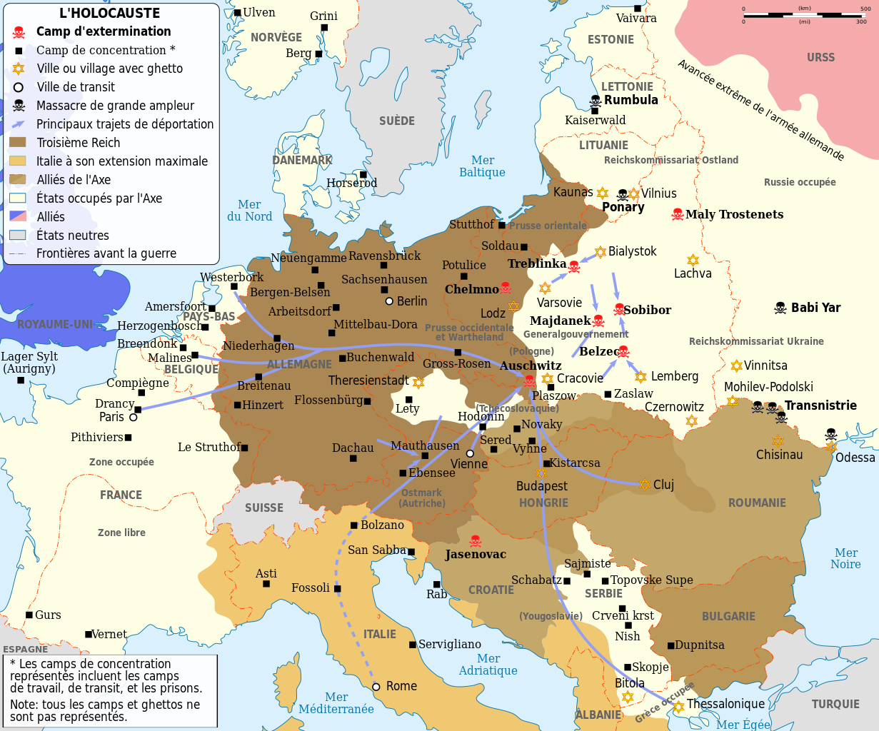
English: Map of the Holocaust in Europe during World War II, 1939-1945. This map shows all extermination camps (or death camps), most major concentration camps, labor camps, prison camps, ghettos, major deportation routes and major massacre sites.
Français : Carte de la Shoah en Europe lors de la Seconde Guerre mondiale (1939-1945). Cette carte montre tous les camps d'extermination (ou « camps de la mort ») et la plupart des principaux camps de concentration, de travail forcé, prisons, itinéraires de déportation et lieux de massacres.
Català: Mapa de L'Holocaust a Europa durant la Segona Guerra Mundial, 1939-1945.
|
||||
| תאריך יצירה | (UTC) | ||||
| מקור | |||||
| יוצר |
|
||||
| גרסאות אחרות |
[]
Derivative works of this file:
| ||||
| ייחוס (required by the license) | © Sémhur / Wikimedia Commons / | ||||
| SVG |
. Inkscape עם נוצרה ה …important
|
||||
| Graphic Lab |


.png)


.png)


| מיקום המצלמה | | תמונה זו ותמונות נוספות במיקום: OpenStreetMap |
|---|
רישיון
אני, בעל זכויות היוצרים על היצירה הזאת, מפרסם אותה בזאת תחת הרישיונות הבאים:
| יוצרים זכויות (copyleft): יצירת האמנות הזאת חופשית; מותר לך להפיץ אותה או לשנות לפי תנאי רישיון אמנות חופשית (Free Art License). אפשר למצוא עותק של הרישיון הזה באתר Copyleft Attitude כמו גם באתרים אחרים. |
This file is licensed under the Creative Commons Attribution-Share Alike 4.0 International, 3.0 Unported, 2.5 Generic, 2.0 Generic and 1.0 Generic license.
- הנכם רשאים:
- לשתף – להעתיק, להפיץ ולהעביר את העבודה
- לערבב בין עבודות – להתאים את העבודה
- תחת התנאים הבאים:
- ייחוס – יש לתת ייחוס הולם, לתת קישור לרישיון, ולציין אם נעשו שינויים. אפשר לעשות את זה בכל צורה סבירה, אבל לא בשום צורה שמשתמע ממנה שמעניק הרישיון תומך בך או בשימוש שלך.
- שיתוף זהה – אם תיצרו רמיקס, תשנו, או תבנו על החומר, חובה עליכם להפיץ את התרומות שלך לפי תנאי רישיון זהה או תואם למקור.
הנכם מוזמנים לבחור את הרישיון הרצוי בעיניכם.
יומן העלאה מקורי
This image is a derivative work of the following images:
- File:WW2-Holocaust-Europe.png licensed with Cc-by-3.0
- 2007-12-20T03:41:38Z Dna-webmaster 1310x1090 (845818 Bytes) new version without "Axis cooperating" in legend
- 2007-12-20T02:00:30Z Dna-webmaster 1310x1090 (844034 Bytes) Now entire West Prussia and Wartheland is included in the Third Reich
- 2007-12-19T16:42:15Z Dna-webmaster 1310x1090 (847461 Bytes) still not Da Vinci, but errors have been corrected (Germany borders West/East), West & East Prussia borders/coloring and Poland General Government corrected borders.
- 2007-12-17T10:46:28Z Dna-webmaster 1310x1090 (844633 Bytes) new map with 1942 borders, not Da Vinci, but here it goes...
- 2007-10-19T13:32:25Z Dna-webmaster 1310x1090 (784727 Bytes) and another update
- 2007-10-19T12:21:52Z Dna-webmaster 1310x1090 (789383 Bytes) quick fix
- 2007-10-19T12:11:07Z Dna-webmaster 1310x1090 (789413 Bytes) {{Information |Description=Map of the Holocaust in Europe during World War II, 1939-1945. This map shows all extermination camps (or ''death camps''), most major concentration camps, work camps, prison camps, ghettos, major
Uploaded with derivativeFX
היסטוריית הקובץ
ניתן ללחוץ על תאריך/שעה כדי לראות את הקובץ כפי שנראה באותו זמן.
| תאריך/שעה | תמונה ממוזערת | ממדים | משתמש | הערה | |
|---|---|---|---|---|---|
| נוכחית | 18:24, 18 בפברואר 2024 | | 1,090 × 1,310 (841 ק"ב) | Ispanas | File uploaded using svgtranslate tool (https://svgtranslate.toolforge.org/). Added translation for lt. |
| 16:30, 18 בפברואר 2024 |  | 1,090 × 1,310 (841 ק"ב) | Ispanas | File uploaded using svgtranslate tool (https://svgtranslate.toolforge.org/). Added translation for lt. | |
| 10:20, 22 בספטמבר 2023 |  | 1,090 × 1,310 (841 ק"ב) | EnjolrasXXI | File uploaded using svgtranslate tool (https://svgtranslate.toolforge.org/). Added translation for ca. | |
| 00:25, 28 באוגוסט 2023 |  | 1,090 × 1,310 (733 ק"ב) | Tholme | Reverted to version as of 14:45, 28 February 2023 (UTC) | |
| 00:24, 28 באוגוסט 2023 |  | 1,090 × 1,310 (490 ק"ב) | Tholme | Reverted to version as of 14:47, 3 June 2021 (UTC) | |
| 17:45, 28 בפברואר 2023 |  | 1,090 × 1,310 (733 ק"ב) | Andrei Stroe | File uploaded using svgtranslate tool (https://svgtranslate.toolforge.org/). Added translation for ro. | |
| 22:26, 29 באוקטובר 2022 |  | 1,090 × 1,310 (625 ק"ב) | Ispanas | File uploaded using svgtranslate tool (https://svgtranslate.toolforge.org/). Added translation for lt. | |
| 10:32, 13 בספטמבר 2021 |  | 1,090 × 1,310 (490 ק"ב) | BIG DADDY Dunkleosteus | Reverted to version as of 14:47, 3 June 2021 (UTC) | |
| 10:31, 13 בספטמבר 2021 |  | 1,090 × 1,310 (555 ק"ב) | BIG DADDY Dunkleosteus | File uploaded using svgtranslate tool (https://svgtranslate.toolforge.org/). Added translation for en. | |
| 17:47, 3 ביוני 2021 |  | 1,090 × 1,310 (490 ק"ב) | Tholme | remove another nested tspan |
שימוש בקובץ
הדף הבא משתמש בקובץ הזה:
שימוש גלובלי בקובץ
אתרי הוויקי השונים הבאים משתמשים בקובץ זה:
- שימוש באתר ca.wikipedia.org
- שימוש באתר de.wikipedia.org
- שימוש באתר en.wikipedia.org
- שימוש באתר fr.wikipedia.org
- Années 1940
- Liste des camps de concentration nazis
- Wikipédia:Atelier graphique/Cartes/Archives/mai 2009
- Shoah
- Convois de la déportation des Juifs de France
- Convois de la déportation des Juifs de Belgique
- Modèle:Palette Camps nazis par type et par pays
- Auschwitz II
- Shoah en France
- Camp de concentration de Potulitz
- Trains de la Shoah
- Ghetto de Białystok
- Ghetto de Kielce
- Camp de concentration de Senftenberg
- Camp de concentration de Mißler
- Utilisateur:Berdea/Convois de la déportation des Juifs de France
- שימוש באתר fr.wikiversity.org
- שימוש באתר fy.wikipedia.org
- שימוש באתר io.wikipedia.org
- שימוש באתר it.wikipedia.org
- שימוש באתר it.wikiquote.org
- שימוש באתר lt.wikipedia.org
- שימוש באתר no.wikipedia.org
- שימוש באתר ro.wikipedia.org
- שימוש באתר sh.wikipedia.org
- שימוש באתר sr.wikipedia.org