
קובץ:Yuma arizona map.jpg

גודל התצוגה המקדימה הזאת: 406 × 599 פיקסלים. רזולוציות אחרות: 162 × 240 פיקסלים | 576 × 850 פיקסלים.
לקובץ המקורי (576 × 850 פיקסלים, גודל הקובץ: 57 ק"ב, סוג MIME: image/jpeg)
| זהו קובץ שמקורו במיזם ויקישיתוף. תיאורו בדף תיאור הקובץ המקורי (בעברית) מוצג למטה. |
| תיאור |
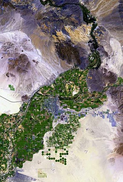
The raw satellite imagery shown in these images was obtained from NASA and/or the US Geological Survey. Post-processing and production by http://www.terraprints.com The en:Colorado River is the border between California, (top, and left), and Arizona, (bottom, and right). The en:Yuma Desert is shown quite prominently, south of Yuma, and the Fortuna Foothills, at the west of the en:Gila Mountains (Yuma County). The Yuma Desert is at the northwest of the Picacho Volcanic field complex, and the great: Gran Desierto de Altar, of north and northwest, Sonora state Mexico. (Note the en:Alluvial fans, especially around the Cargo Muchacho Mountains of California, but throughout the photo.) |
| תאריך יצירה | |
| מקור | http://www.terraprints.com |
| יוצר | http://www.terraprints.com |
הקובץ הזה מתפרסם לפי תנאי רישיון קריאייטיב קומונז ייחוס 2.5 כללי.
- הנכם רשאים:
- לשתף – להעתיק, להפיץ ולהעביר את העבודה
- לערבב בין עבודות – להתאים את העבודה
- תחת התנאים הבאים:
- ייחוס – יש לתת ייחוס הולם, לתת קישור לרישיון, ולציין אם נעשו שינויים. אפשר לעשות את זה בכל צורה סבירה, אבל לא בשום צורה שמשתמע ממנה שמעניק הרישיון תומך בך או בשימוש שלך.
| Annotations | This image is annotated: View the annotations at Commons |
היסטוריית הקובץ
ניתן ללחוץ על תאריך/שעה כדי לראות את הקובץ כפי שנראה באותו זמן.
| תאריך/שעה | תמונה ממוזערת | ממדים | משתמש | הערה | |
|---|---|---|---|---|---|
| נוכחית | 20:49, 25 בספטמבר 2007 | | 850 × 576 (57 ק"ב) | Marku1988 | |
| 21:52, 25 באוקטובר 2006 |  | 1,000 × 671 (67 ק"ב) | Terraprints | {{Information |Description=The raw satellite imagery shown in these images was obtain from NASA and/or the US Geological Survey. Post-processing and production by http://www.terraprints.com |Source=http://www.terraprints.com |Date=20061025 |Author=http:// |
שימוש בקובץ
הדף הבא משתמש בקובץ הזה:
שימוש גלובלי בקובץ
אתרי הוויקי השונים הבאים משתמשים בקובץ זה:
- שימוש באתר arz.wikipedia.org
- שימוש באתר ceb.wikipedia.org
- שימוש באתר en.wikipedia.org
- שימוש באתר es.wikipedia.org
- שימוש באתר fr.wikipedia.org
- שימוש באתר fy.wikipedia.org
- שימוש באתר ja.wikipedia.org
- שימוש באתר lld.wikipedia.org
- שימוש באתר nn.wikipedia.org
- שימוש באתר www.wikidata.org
- שימוש באתר zh.wikipedia.org