
קובץ:Athabasca Oil Sands map.png

גודל התצוגה המקדימה הזאת: 410 × 599 פיקסלים. רזולוציות אחרות: 164 × 240 פיקסלים | 328 × 480 פיקסלים | 526 × 768 פיקסלים | 1,200 × 1,753 פיקסלים.
לקובץ המקורי (1,200 × 1,753 פיקסלים, גודל הקובץ: 611 ק"ב, סוג MIME: image/png)
| זהו קובץ שמקורו במיזם ויקישיתוף. תיאורו בדף תיאור הקובץ המקורי (בעברית) מוצג למטה. |
תקציר
| תיאור |
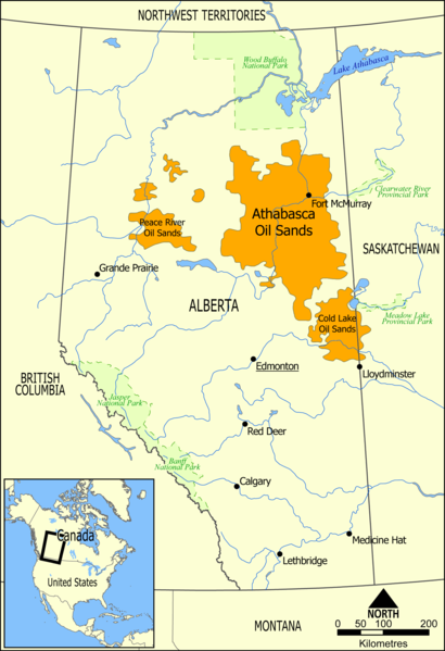
English: This map shows the extent of the oil sands in Alberta, Canada. The three oil sand deposits are known as the Athabasca Oil Sands, the Cold Lake Oil Sands, and the Peace River Oil Sands. |
| תאריך יצירה | |
| מקור | נוצר על־ידי מעלה היצירה |
| יוצר | NormanEinstein |
| גרסאות אחרות |
Derivative works of this file: Athabasca oil sand mining map 2011.jpg: |
רישיון
| ברצוני, בעלי זכויות היוצרים על יצירה זו, לשחרר יצירה זו לנחלת הכלל. זה תקף בכל העולם. יש מדינות שבהן הדבר אינו אפשרי על פי חוק, אם כך: אני מעניק לכל אחד את הזכות להשתמש בעבודה זו לכל מטרה שהיא, ללא תנאים כלשהם, אלא אם כן תנאים כאלה נדרשים על פי חוק. |
היסטוריית הקובץ
ניתן ללחוץ על תאריך/שעה כדי לראות את הקובץ כפי שנראה באותו זמן.
| תאריך/שעה | תמונה ממוזערת | ממדים | משתמש | הערה | |
|---|---|---|---|---|---|
| נוכחית | 19:49, 10 במאי 2006 | | 1,753 × 1,200 (611 ק"ב) | NormanEinstein | This map shows the extent of the oils sands in Alberta, Canada. The three oil sand deposits are known as the Athabasca Oil Sands, the Cold Lake Oil Sands, and the Peace River Oil Sands. Created by NormanEinstein, May 10, 2006. {{GFDL-self}} [[Category: |
שימוש בקובץ
הדפים הבאים משתמשים בקובץ הזה:
שימוש גלובלי בקובץ
אתרי הוויקי השונים הבאים משתמשים בקובץ זה:
- שימוש באתר ar.wikipedia.org
- שימוש באתר bg.wikipedia.org
- שימוש באתר ca.wikipedia.org
- שימוש באתר cs.wikipedia.org
- שימוש באתר da.wikipedia.org
- שימוש באתר de.wikipedia.org
- שימוש באתר el.wikipedia.org
- שימוש באתר en.wikipedia.org
- Ernest Manning
- Oil sands
- Athabasca oil sands
- User:NormanEinstein/gallery
- Template:Text-superimpose
- Wabasca oil field
- History of the petroleum industry in Canada (oil sands and heavy oil)
- Kearl Oil Sands Project
- Cold Lake oil sands
- Peace River oil sands
- Oil sands tailings ponds (Canada)
- Tar Sands Healing Walk
- User:Klausronjaen/sandbox
- Georg Naumann
- User:Garrett.Nielsen/sandbox
- Environmental issues in Alberta
- Timeline of the petroleum industry in Alberta
- Template:Text-superimpose/doc
- Template:Text-superimpose/sandbox
- History of the Petroleum industry in Alberta
- Legacy pollution
- User:Spencerladner/Legacy pollution
- שימוש באתר en.wikinews.org
- שימוש באתר es.wikipedia.org
- שימוש באתר fa.wikipedia.org
- שימוש באתר fi.wikipedia.org
- שימוש באתר fr.wikipedia.org
- שימוש באתר gl.wikipedia.org
- שימוש באתר it.wikipedia.org
- שימוש באתר ja.wikipedia.org
- שימוש באתר la.wikipedia.org