
קובץ:Balearic Sea map.png
גודל התצוגה המקדימה הזאת: 800 × 511 פיקסלים. רזולוציות אחרות: 320 × 204 פיקסלים | 640 × 409 פיקסלים | 1,000 × 639 פיקסלים.
לקובץ המקורי (1,000 × 639 פיקסלים, גודל הקובץ: 77 ק"ב, סוג MIME: image/png)
| זהו קובץ שמקורו במיזם ויקישיתוף. תיאורו בדף תיאור הקובץ המקורי (בעברית) מוצג למטה. |
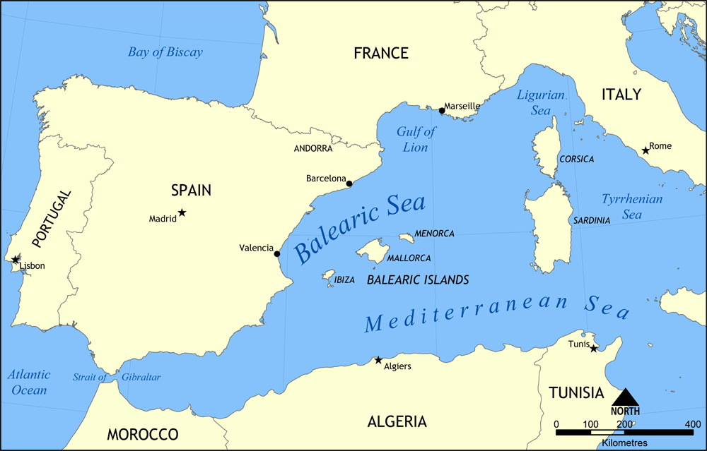
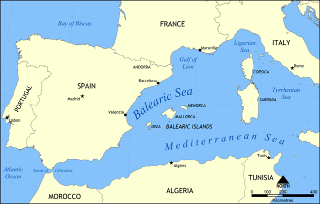
Map showing the location of the Balearic Sea, part of the Mediterranean Sea.
Created by NormanEinstein, May 26, 2006.
אני, בעל זכויות היוצרים על עבודה זו, מפרסם בזאת את העבודה תחת הרישיון הבא:

|
מוענקת בכך הרשות להעתיק, להפיץ או לשנות את המסמך הזה, לפי תנאי הרישיון לשימוש חופשי במסמכים של גנו, גרסה 1.2 או כל גרסה מאוחרת יותר שתפורסם על־ידי המוסד לתוכנה חופשית; ללא פרקים קבועים, ללא טקסט עטיפה קדמית וללא טקסט עטיפה אחורית. עותק של הרישיון כלול בפרק שכותרתו הרישיון לשימוש חופשי במסמכים של גנו. |
| הקובץ הזה מתפרסם לפי תנאי רישיון קריאייטיב קומונז ייחוס-שיתוף זהה 3.0 לא מותאם. | ||
| ||
| תבנית רישוי זו הוספה לקובץ כחלק מעדכון רישיון GFDL. |
היסטוריית הקובץ
ניתן ללחוץ על תאריך/שעה כדי לראות את הקובץ כפי שנראה באותו זמן.
| תאריך/שעה | תמונה ממוזערת | ממדים | משתמש | הערה | |
|---|---|---|---|---|---|
| נוכחית | 18:31, 26 במאי 2006 | | 639 × 1,000 (77 ק"ב) | NormanEinstein | Map showing the location of the Balearic Sea, part of the Mediterranean Sea. Created by NormanEinstein, May 26, 2006. {{GFDL-self}} Category:Maps of seas |
שימוש בקובץ
הדפים הבאים משתמשים בקובץ הזה:
שימוש גלובלי בקובץ
אתרי הוויקי השונים הבאים משתמשים בקובץ זה:
- שימוש באתר af.wikipedia.org
- שימוש באתר an.wikipedia.org
- שימוש באתר avk.wikipedia.org
- שימוש באתר az.wikipedia.org
- שימוש באתר az.wiktionary.org
- שימוש באתר be.wikipedia.org
- שימוש באתר bg.wikipedia.org
- שימוש באתר bn.wikipedia.org
- שימוש באתר bs.wikipedia.org
- שימוש באתר ca.wikipedia.org
- שימוש באתר ce.wikipedia.org
- שימוש באתר ckb.wikipedia.org
- שימוש באתר cv.wikipedia.org
- שימוש באתר da.wikipedia.org
- שימוש באתר en.wikipedia.org
- HMS Nelson (28)
- French battleship Bouvet
- Balearic Sea
- Malta convoys
- User:NormanEinstein/gallery
- French ironclad Dévastation
- French battleship Mirabeau
- French battleship Justice
- French battleship Vérité
- French battleship République
- French battleship Patrie
- French ironclad Magenta (1890)
- French battleship Charles Martel
- French battleship Brennus
- French ironclad Marceau
- French ironclad Neptune
- French cruiser Lavoisier
- French cruiser Troude
- Action of 19 February 1801
- User talk:Keith-264/sandbox5
- French cruiser Milan
- French cruiser Tage
- French cruiser Sfax
- French cruiser Forbin
- French cruiser Lalande
- French cruiser Cosmao
- French cruiser Cassard
- French cruiser Du Chayla
- French cruiser D'Iberville
- French cruiser Casabianca
- שימוש באתר es.wikipedia.org