
קובץ:1864 Johnson Map of the Roman Empire - Geographicus - RomanEmpire-johnson-1864.jpg
גודל התצוגה המקדימה הזאת: 800 × 493 פיקסלים. רזולוציות אחרות: 320 × 197 פיקסלים | 640 × 395 פיקסלים | 1,024 × 632 פיקסלים | 1,280 × 789 פיקסלים | 2,560 × 1,579 פיקסלים | 4,000 × 2,467 פיקסלים.
לקובץ המקורי (4,000 × 2,467 פיקסלים, גודל הקובץ: 3.46 מ"ב, סוג MIME: image/jpeg)
| זהו קובץ שמקורו במיזם ויקישיתוף. תיאורו בדף תיאור הקובץ המקורי (בעברית) מוצג למטה. |
| Alvin Jewett Johnson: Johnson's Roman Empire, Imperium Romanorum Latissime Patens.
( |
|||||||||||||||||||||||
|---|---|---|---|---|---|---|---|---|---|---|---|---|---|---|---|---|---|---|---|---|---|---|---|
| אומן |
|
||||||||||||||||||||||
| כותרת |
Johnson's Roman Empire, Imperium Romanorum Latissime Patens. |
||||||||||||||||||||||
| תיאור |
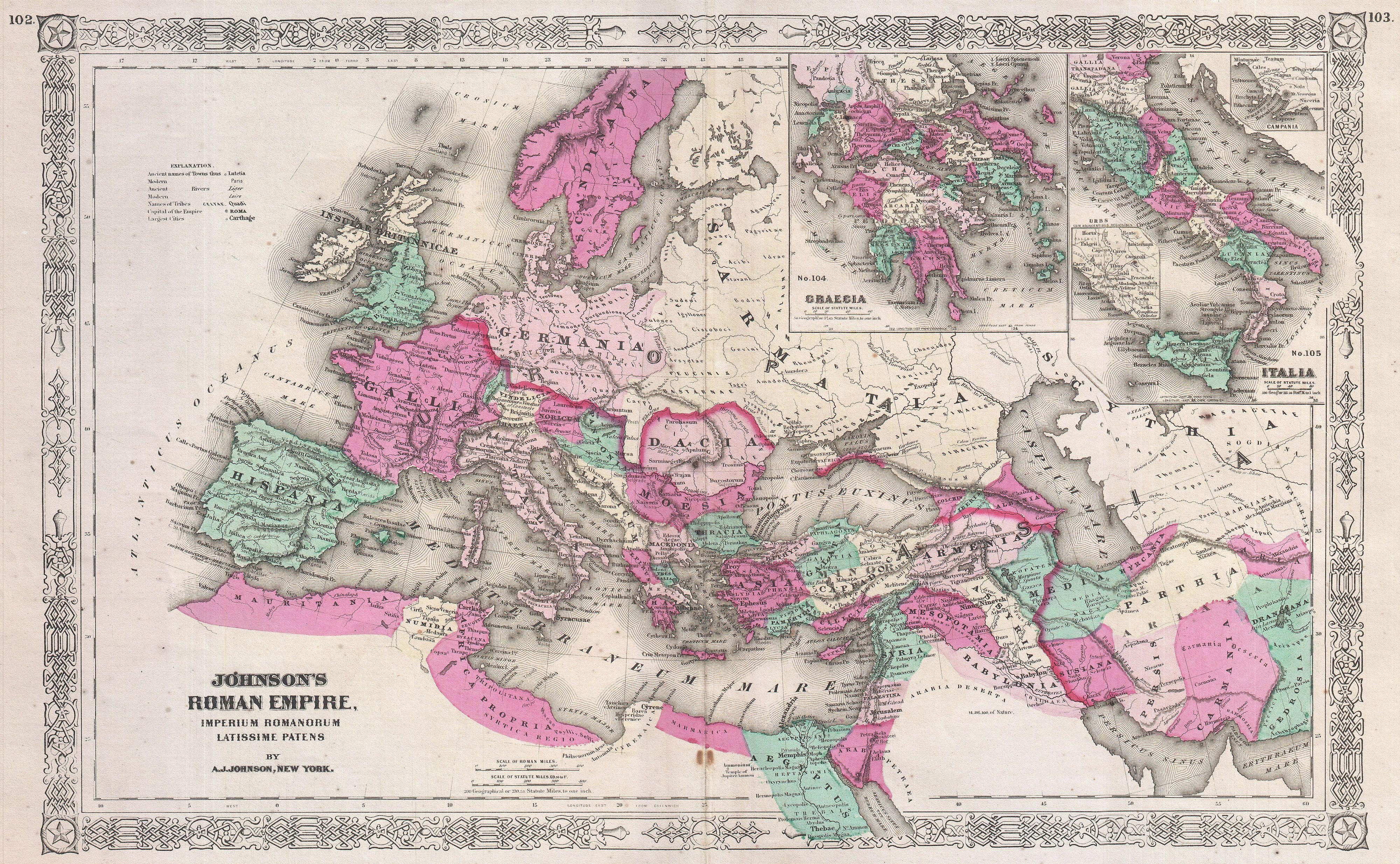
English: This is A. J. Johnson’s c. 1864 map of the Roman Empire. Depicts the whole of Europe as well as parts of North Africa, Asia and Persia. Inset maps in the upper right quadrant detail Greece and the Italian Peninsula. Features the Grecian style border common to Johnson’s atlas work from 1864 to 1869. Prepared by A. J. Johnson for publication as plates no. 102 and 103 in the 1864 edition of his New Illustrated Atlas… . |
||||||||||||||||||||||
| תאריך יצירה | 1864 (unndated) | ||||||||||||||||||||||
| ממדים | גובה: 13.5 in (34.2 ס"מ); רוחב: 21.5 in (54.6 ס"מ) | ||||||||||||||||||||||
| מספר גישה |
Geographicus link: RomanEmpire-johnson-1864 |
||||||||||||||||||||||
| מקור/צלם |
Johnson's New Illustrated (Steel Plate) Family Atlas, (1864 or 1865 edition).
|
||||||||||||||||||||||
| אישורים והיתרים (שימוש חוזר בקובץ זה) |
|
||||||||||||||||||||||
היסטוריית הקובץ
ניתן ללחוץ על תאריך/שעה כדי לראות את הקובץ כפי שנראה באותו זמן.
| תאריך/שעה | תמונה ממוזערת | ממדים | משתמש | הערה | |
|---|---|---|---|---|---|
| נוכחית | 23:40, 17 במרץ 2011 | | 2,467 × 4,000 (3.46 מ"ב) | BotMultichill | {{subst:User:Multichill/Geographicus |link=http://www.geographicus.com/P/AntiqueMap/RomanEmpire-johnson-1864 |product_name=1864 Johnson Map of the Roman Empire |map_title=Johnson's Roman Empire, Imperium Romanorum Latissime Patens. |description=This is A. |
שימוש בקובץ
הדף הבא משתמש בקובץ הזה:
שימוש גלובלי בקובץ
אתרי הוויקי השונים הבאים משתמשים בקובץ זה:
- שימוש באתר el.wikipedia.org
- שימוש באתר en.wikipedia.org
- שימוש באתר fr.wikipedia.org
- שימוש באתר gl.wikipedia.org
- שימוש באתר hy.wikipedia.org
- שימוש באתר ja.wikipedia.org
- שימוש באתר mk.wikipedia.org
- שימוש באתר ru.wikipedia.org
- שימוש באתר uk.wikipedia.org
- שימוש באתר zh.wikipedia.org