
קובץ:1867 Beers Map of Yonkers - Tibbetts Brook 02.jpg

גודל התצוגה המקדימה הזאת: 396 × 599 פיקסלים. רזולוציות אחרות: 158 × 240 פיקסלים | 317 × 480 פיקסלים | 507 × 768 פיקסלים | 676 × 1,024 פיקסלים | 1,701 × 2,575 פיקסלים.
לקובץ המקורי (1,701 × 2,575 פיקסלים, גודל הקובץ: 1.3 מ"ב, סוג MIME: image/jpeg)
| זהו קובץ שמקורו במיזם ויקישיתוף. תיאורו בדף תיאור הקובץ המקורי (בעברית) מוצג למטה. |
תקציר
| תיאור |
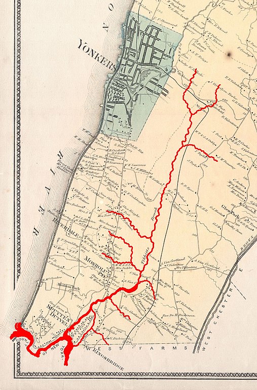
English: This is the scarce Yonkers sheet from Beers’ 1867 Atlas of Westchester County, New York, showing modern-day Yonkers and Western Bronx. Highlighted in red are the course and various tributaries of Tibbetts Brook, and Spuyten Duyvil Creek which once separated the Bronx and Manhattan island. |
||
| תאריך יצירה | |||
| מקור |
|
||
| יוצר |
http://www.geographicus.com/mm5/cartographers/beers.txt (Map) Tdorante10 (Highlighting of river) |
||
| גרסאות אחרות |
,_New_York_-_Geographicus_-_Yonkers-beers-1867.jpg)
רישיון
|
עבודת אמנות דו-מימדית זו המוצגת בתמונה שוחררה לרשות הציבור בכל העולם בעקבות תאריך מותו של היוצר, או תאריך פרסום היצירה. לפיכך, תצלום היצירה גם הוא ברשות הציבור.
הודעה זו תקפה לגבי התצלומים שנוצרו בארצות הברית, בגרמניה ובמדינות רבות נוספות.
|
היסטוריית הקובץ
ניתן ללחוץ על תאריך/שעה כדי לראות את הקובץ כפי שנראה באותו זמן.
| תאריך/שעה | תמונה ממוזערת | ממדים | משתמש | הערה | |
|---|---|---|---|---|---|
| נוכחית | 01:07, 19 בפברואר 2017 | | 2,575 × 1,701 (1.3 מ"ב) | Tdorante10 | User created page with UploadWizard |
שימוש בקובץ
הדף הבא משתמש בקובץ הזה:
שימוש גלובלי בקובץ
אתרי הוויקי השונים הבאים משתמשים בקובץ זה:
- שימוש באתר en.wikipedia.org