
קובץ:Administrative division of denmark in medieval times.jpg
לקובץ המקורי (5,952 × 4,336 פיקסלים, גודל הקובץ: 15.8 מ"ב, סוג MIME: image/jpeg)
| זהו קובץ שמקורו במיזם ויקישיתוף. תיאורו בדף תיאור הקובץ המקורי (בעברית) מוצג למטה. |
תקציר
| תיאור |
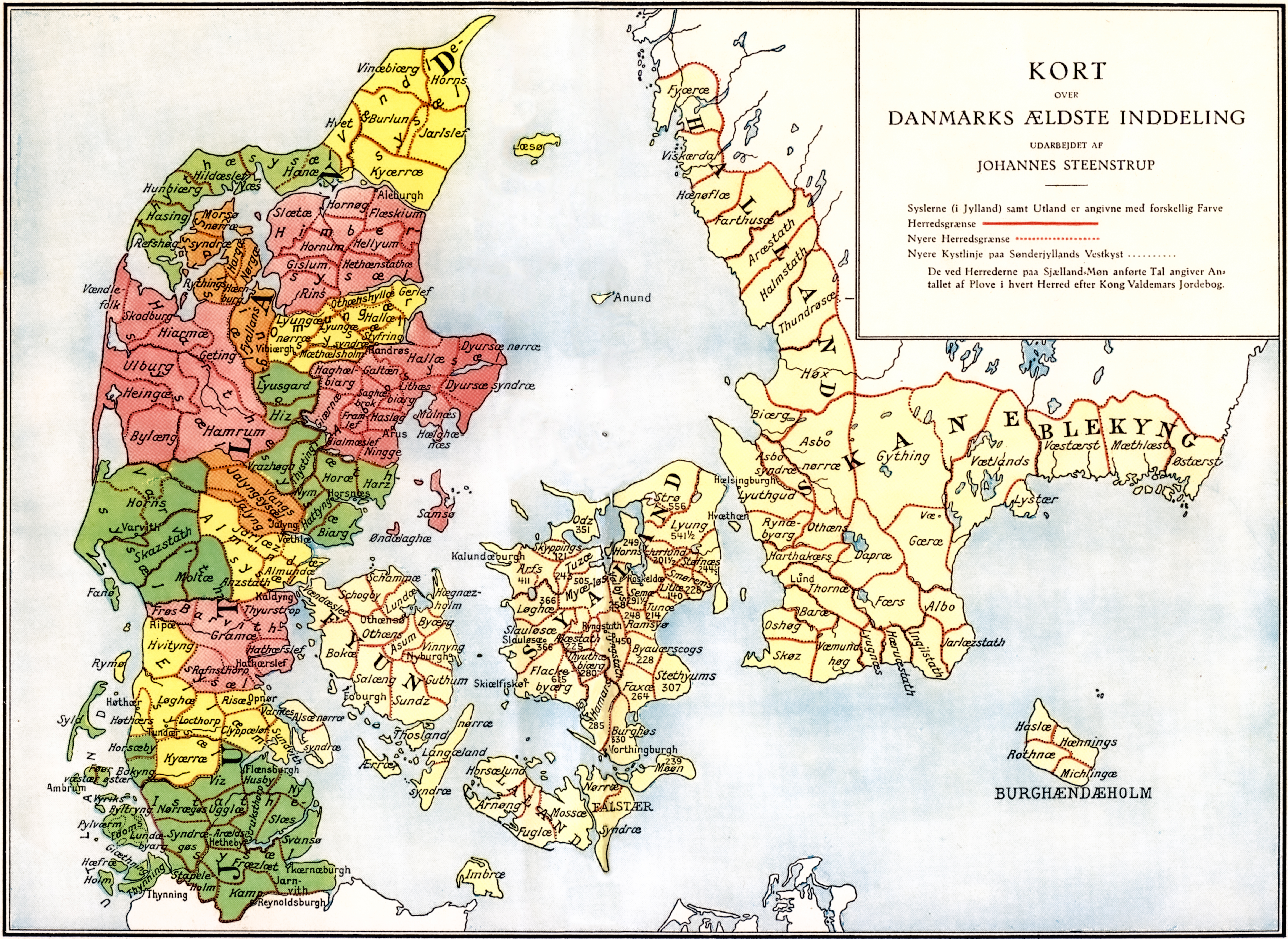
Administrative division of Denmark in Medieval times. |
||||||||||||||||||||
| Map legend | The different colors indicate the division in sysler in Jutland while the red lines indicate borders between herreder (hundreds). Dotted red lines indicate newer borders. Note:The purely ecclesiastic sysler on Zealand are not included on this map. | ||||||||||||||||||||
| מקור | The map was made by professor Johannes Steenstrup (died 1935) for use in Danmarks Riges Historie (1900, after page 625) and is in Public Domain since Steenstrup died more than 70 years ago. | ||||||||||||||||||||
| יוצר |
|
||||||||||||||||||||
| אישורים והיתרים (שימוש חוזר בקובץ זה) |
|
||||||||||||||||||||
| Georeferencing | If inappropriate please set warp_status = skip to hide. | ||||||||||||||||||||
| גרסאות אחרות | |||||||||||||||||||||


.jpg)

.jpg)
.jpg)
.jpg)
.jpg)
.jpg)
.jpg)
.jpg)
.jpg)
.jpg)
.jpg)
.jpg)
.jpg)


.jpg)
היסטוריית הקובץ
ניתן ללחוץ על תאריך/שעה כדי לראות את הקובץ כפי שנראה באותו זמן.
| תאריך/שעה | תמונה ממוזערת | ממדים | משתמש | הערה | |
|---|---|---|---|---|---|
| נוכחית | 19:30, 12 ביוני 2019 | | 4,336 × 5,952 (15.8 מ"ב) | Aeroid | removed vertical lines, straight, slight color change |
| 08:36, 19 ביוני 2005 |  | 4,336 × 5,952 (16.87 מ"ב) | Heelgrasper | Administrative division of Denmark in Medieval times. The different colors indicate the division in "sysler" in Jutland while the red lines indicate borders between "herreder" (counties). Dotted red lines indicate never borders. The map is made by profes |
שימוש בקובץ
הדף הבא משתמש בקובץ הזה:
שימוש גלובלי בקובץ
אתרי הוויקי השונים הבאים משתמשים בקובץ זה:
- שימוש באתר cs.wikipedia.org
- שימוש באתר da.wikipedia.org
- שימוש באתר de.wikipedia.org
- שימוש באתר en.wikipedia.org
- שימוש באתר eo.wikipedia.org
- שימוש באתר es.wikipedia.org
- שימוש באתר et.wikipedia.org
- שימוש באתר fi.wikipedia.org
- שימוש באתר frr.wikipedia.org
- שימוש באתר fr.wikipedia.org
- שימוש באתר hu.wikipedia.org
- שימוש באתר id.wikipedia.org
- שימוש באתר it.wikipedia.org
- שימוש באתר ko.wikipedia.org
- שימוש באתר la.wikipedia.org
- שימוש באתר nds.wikipedia.org
- שימוש באתר nl.wikipedia.org
- שימוש באתר no.wikipedia.org