
קובץ:Australia first map.jpg

לקובץ המקורי (3,604 × 2,696 פיקסלים, גודל הקובץ: 3.81 מ"ב, סוג MIME: image/jpeg)
| זהו קובץ שמקורו במיזם ויקישיתוף. תיאורו בדף תיאור הקובץ המקורי (בעברית) מוצג למטה. |
תקציר
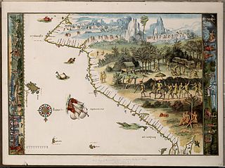
Facsimile of chart from Nicholas Vallard's manuscript sea atlas (1547), showing Jave La Grande's west coast. The facsimile was given the title "The first Map of Australia from Nicholas Vallard's Atlas, 1547" by the English publisher in 1856. The original Vallard chart was produced in Dieppe, France in the 16th century. It is thought by several writers to represent Portuguese charting of the western coast of Australia, however the geographical features (i.e. 'cap' cape, 'Illa' Island, 'illet' islet, 'port' harbour) are actually written in Catalan. This copy is held by the National Library of Australia. [cartographic material] : from the Library of Sir Thomas Phillipps, Bart. at Middle Hill, 1856. Image from the National Library of Australia: http://nla.gov.au/nla.map-rm2393 The original Vallard map is held by the Huntington Library, San Marino, California and can be viewed at http://sunsite3.berkeley.edu/hehweb/HM29.html archive copy at the Wayback Machine
From NLA catalogure information: Scale: Scale indeterminable. Publisher: [Worcestershire : Middle Hill Press, 1856] (Chester : McGahey chromo. lith.) Date: 1856 Material Type: Map Physical Description: 1 map : col. ; 37.6 x 55.4 cm. Notes: Facsimile of chart from Nicholas Vallard's manuscript sea atlas (1547), now held in the Huntington Library, San Marino, California.
Map is in folder with title: Vallard's map of the coast of Greater Java.
רישיון
|
יצירה זו נמצאת בנחלת הכלל במדינת המקור ובמדינות אחרות בהם תקופת זכויות היוצרים היא משך חיי היוצר ו-70 שנה (או פחות) מפטירתו.
| |
| הקובץ הזה זוהה כקובץ חופשי מכל מגבלה ידועה תחת חוק זכויות היוצרים, כולל כל הזכויות הקשורות והסמוכות. | |
היסטוריית הקובץ
ניתן ללחוץ על תאריך/שעה כדי לראות את הקובץ כפי שנראה באותו זמן.
| תאריך/שעה | תמונה ממוזערת | ממדים | משתמש | הערה | |
|---|---|---|---|---|---|
| נוכחית | 03:58, 17 באוקטובר 2006 | | 2,696 × 3,604 (3.81 מ"ב) | Gobeirne | |
| 01:55, 1 בדצמבר 2005 |  | 580 × 760 (110 ק"ב) | Matilda | First map of Australia [cartographic material] : from Nicholas Vallard's atlas, 1547, in the Library of Sir Thomas Phillipps, Bart. at Middle Hill, 1856. Image from the National Library of Australia: http://nla.gov.au/nla.map-rm2393 From NLA catalogure i |
שימוש בקובץ
הדף הבא משתמש בקובץ הזה:
שימוש גלובלי בקובץ
אתרי הוויקי השונים הבאים משתמשים בקובץ זה:
- שימוש באתר af.wikipedia.org
- שימוש באתר en.wikipedia.org
- שימוש באתר es.wikipedia.org
- שימוש באתר fr.wikipedia.org
- שימוש באתר id.wikipedia.org
- שימוש באתר it.wikipedia.org
- שימוש באתר ja.wikipedia.org
- שימוש באתר jv.wikipedia.org
- שימוש באתר ka.wikipedia.org
- שימוש באתר mk.wikipedia.org
- שימוש באתר nl.wikipedia.org
- שימוש באתר pt.wikipedia.org
- Descoberta da Austrália
- Predefinição:Esboço-históriaau
- Mapas de Dieppe
- Colônia de Nova Gales do Sul
- Ordem da Austrália
- Teoria da descoberta da Austrália pelos portugueses
- Eureka Stockade
- Federação da Austrália
- Austrália Branca
- Colônia da Tasmânia
- Colônia de Queensland
- Federalismo na Austrália
- João Alfonso
- שימוש באתר ru.wikipedia.org
- שימוש באתר ru.wikiversity.org
- שימוש באתר sr.wikipedia.org
- שימוש באתר tr.wikipedia.org