
קובץ:Carl Zimmermann, Terrainkarte von Jerusalem und Umgebung vor der Besiedelung (FL51415413 2761974).jpg

גודל התצוגה המקדימה הזאת: 459 × 599 פיקסלים. רזולוציות אחרות: 184 × 240 פיקסלים | 368 × 480 פיקסלים | 589 × 768 פיקסלים | 785 × 1,024 פיקסלים | 1,570 × 2,048 פיקסלים | 11,764 × 15,347 פיקסלים.
לקובץ המקורי (11,764 × 15,347 פיקסלים, גודל הקובץ: 267.35 מ"ב, סוג MIME: image/jpeg)
| זהו קובץ שמקורו במיזם ויקישיתוף. תיאורו בדף תיאור הקובץ המקורי (בעברית) מוצג למטה. |
תקציר
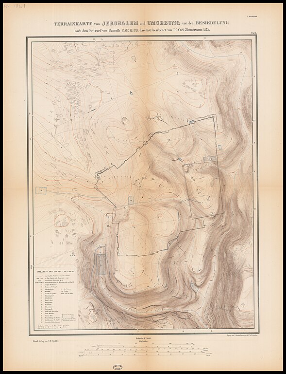
| Carl Zimmermann: Terrainkarte von Jerusalem und Umgebung vor der Besiedelung
( |
||||||||||||||||||||||||
|---|---|---|---|---|---|---|---|---|---|---|---|---|---|---|---|---|---|---|---|---|---|---|---|---|
| אומן |
| |||||||||||||||||||||||
| יוצרים נוספים | Wurster, Radegger & Cie. Schick, Conrad, 1822-1901 | |||||||||||||||||||||||
| כותרת |
Terrainkarte von Jerusalem und Umgebung vor der Besiedelung |
|||||||||||||||||||||||
| מפרסם |
Spittler |
|||||||||||||||||||||||
| תיאור |
Terrainkarte von Jerusalem und Umgebung vor der Besiedelung. nach dem Entwurf von Baurath C.Schick . bearbeitet von Dr. Carl Zimmermann. |
|||||||||||||||||||||||
| שפה | גרמנית | |||||||||||||||||||||||
| תאריך הוצאה לאור | 1876 | |||||||||||||||||||||||
| ממדים | גובה: 51 ס"מ; רוחב: 40 ס"מ | |||||||||||||||||||||||
| אוסף |
|
|||||||||||||||||||||||
| מיקום נוכחי |
|
|||||||||||||||||||||||
| מיקום הוצאה | בזל | |||||||||||||||||||||||
| חיפוש בקטלוג מרחב | בזל | |||||||||||||||||||||||
| הערות | From: Zimmermann, Carl. Karte und Plaene zur Topographie des Alten Jerusalem. Basel, 1876 (34 B 943 - Portfolio).; Topogr. Anst. v. Wurnster, Randegger & C.ie in Winterthur.; Plan drawn after Schick and corrected by Zimmermann; Taf.I | |||||||||||||||||||||||
| קנה מידה | 1:5,000 cm | |||||||||||||||||||||||
| IE PID | IE51415411 | |||||||||||||||||||||||
| רוזטה שם קובץ | FL51415413 | |||||||||||||||||||||||
| מזהה רשומה בספרייה הלאומית (P3959) | 990027619740205171 | |||||||||||||||||||||||
| חיפוש בקטלוג מרחב | גרמנית, Carl Zimmermann | |||||||||||||||||||||||
| חיפוש בקטלוג מרחב | Spittler | |||||||||||||||||||||||
| מקור/צלם |
|
|||||||||||||||||||||||
| גרסאות אחרות | ||||||||||||||||||||||||
| Jpg / Tif version |
|
|||||||||||||||||||||||

.jpg)

.jpg)
.jpg?uselang=he)
רישיון
The copyright situation of this work is theoretically uncertain, because in the country of origin copyright lasts 70 years after the death of the author, and the date of the author's death is unknown. However, the date of creation of the work was over 120 years ago, and it is thus a reasonable assumption that the copyright has expired (see here for the community discussion). Do not use this template if the date of death of the author is known.
| |
| הקובץ הזה זוהה כקובץ חופשי מכל מגבלה ידועה תחת חוק זכויות היוצרים, כולל כל הזכויות הקשורות והסמוכות. | |
היסטוריית הקובץ
ניתן ללחוץ על תאריך/שעה כדי לראות את הקובץ כפי שנראה באותו זמן.
| תאריך/שעה | תמונה ממוזערת | ממדים | משתמש | הערה | |
|---|---|---|---|---|---|
| נוכחית | 18:09, 4 בספטמבר 2023 | | 15,347 × 11,764 (267.35 מ"ב) | Geagea | pattypan 22.03 |
שימוש בקובץ
![]() אין בוויקיפדיה דפים המשתמשים בקובץ זה.
אין בוויקיפדיה דפים המשתמשים בקובץ זה.
.jpg)