
קובץ:Cornelis de Bruijn, Tabula Geographica continens Vestigia et Proceßum Itineris Tant Martimi quam Terrestris (FL6881263 2368399).jpg

גודל התצוגה המקדימה הזאת: 800 × 469 פיקסלים. רזולוציות אחרות: 320 × 188 פיקסלים | 640 × 375 פיקסלים | 1,024 × 601 פיקסלים | 1,280 × 751 פיקסלים | 3,274 × 1,920 פיקסלים.
לקובץ המקורי (3,274 × 1,920 פיקסלים, גודל הקובץ: 2.64 מ"ב, סוג MIME: image/jpeg)
| זהו קובץ שמקורו במיזם ויקישיתוף. תיאורו בדף תיאור הקובץ המקורי (בעברית) מוצג למטה. |
תקציר
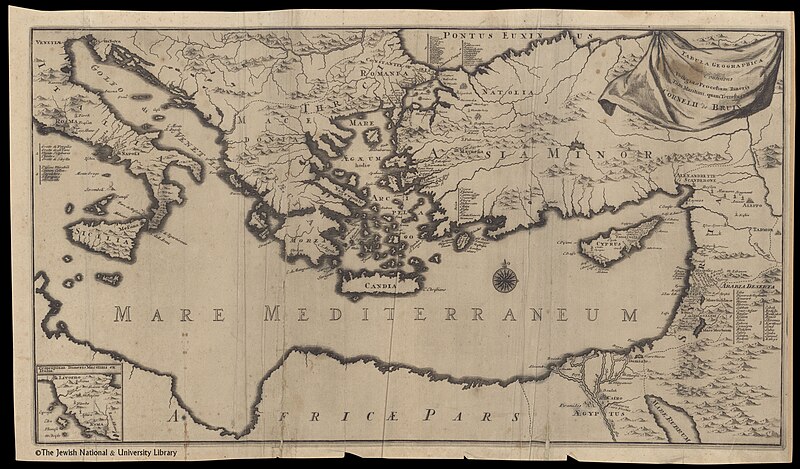
| קורנליס דה ברוין: Tabula Geographica continens Vestigia et Proceßum Itineris Tant Martimi quam Terrestris
( |
||||||||||||||||||||||||
|---|---|---|---|---|---|---|---|---|---|---|---|---|---|---|---|---|---|---|---|---|---|---|---|---|
| אומן |
| |||||||||||||||||||||||
| יוצרים נוספים | Krooneveld, Henrik van | |||||||||||||||||||||||
| כותרת |
Tabula Geographica continens Vestigia et Proceßum Itineris Tant Martimi quam Terrestris |
|||||||||||||||||||||||
| מפרסם |
Henrik van Krooneveld |
|||||||||||||||||||||||
| תיאור |
Tabula Geographica continens Vestigia et Proceßum Itineris Tant Martimi quam Terrestris. Cornelii de Bruin. |
|||||||||||||||||||||||
| שפה | לטינית | |||||||||||||||||||||||
| תאריך הוצאה לאור | 1700 | |||||||||||||||||||||||
| ממדים | גובה: 312 מ"מ; רוחב: 576 מ"מ | |||||||||||||||||||||||
| אוסף |
|
|||||||||||||||||||||||
| מיקום נוכחי |
|
|||||||||||||||||||||||
| מיקום הוצאה | דלפט | |||||||||||||||||||||||
| חיפוש בקטלוג מרחב | דלפט | |||||||||||||||||||||||
| הערות | Copperplate; Inset: Principium itineris maritimi ex Italia; From: Bruyn, Cornelis de. Voyage au Levant... Delft, Henri van Kroonevelt, 1700. Before Fol. 1. | |||||||||||||||||||||||
| IE PID | IE6881261 | |||||||||||||||||||||||
| רוזטה שם קובץ | FL6881263 | |||||||||||||||||||||||
| מזהה רשומה בספרייה הלאומית (P3959) | 990023683990205171 | |||||||||||||||||||||||
| חיפוש בקטלוג מרחב | לטינית, קורנליס דה ברוין | |||||||||||||||||||||||
| חיפוש בקטלוג מרחב | Henrik van Krooneveld | |||||||||||||||||||||||
| מקור/צלם |
|
|||||||||||||||||||||||
| גרסאות אחרות | ||||||||||||||||||||||||
| Jpg / Tif version |
|
|||||||||||||||||||||||
.jpg)

.jpg)

.jpg)
.jpg?uselang=he)
רישיון
The copyright situation of this work is theoretically uncertain, because in the country of origin copyright lasts 70 years after the death of the author, and the date of the author's death is unknown. However, the date of creation of the work was over 120 years ago, and it is thus a reasonable assumption that the copyright has expired (see here for the community discussion). Do not use this template if the date of death of the author is known.
| |
| הקובץ הזה זוהה כקובץ חופשי מכל מגבלה ידועה תחת חוק זכויות היוצרים, כולל כל הזכויות הקשורות והסמוכות. | |
היסטוריית הקובץ
ניתן ללחוץ על תאריך/שעה כדי לראות את הקובץ כפי שנראה באותו זמן.
| תאריך/שעה | תמונה ממוזערת | ממדים | משתמש | הערה | |
|---|---|---|---|---|---|
| נוכחית | 09:56, 28 ביולי 2023 | | 1,920 × 3,274 (2.64 מ"ב) | Geagea | pattypan 22.03 |
שימוש בקובץ
![]() אין בוויקיפדיה דפים המשתמשים בקובץ זה.
אין בוויקיפדיה דפים המשתמשים בקובץ זה.
.jpg)