
קובץ:View looking west along west along west 155th street viaduct - Macombs Dam Bridge, Spanning Harlem River Between 155th Street Viaduct, Jerome Avenue, and East 162nd Street, Bronx HAER NY,31-NEYO,175-2.tif

גודל התצוגה המקדימה הזאת מסוג JPG של קובץ ה־TIF הזה: 743 × 599 פיקסלים. רזולוציות אחרות: 298 × 240 פיקסלים | 595 × 480 פיקסלים | 952 × 768 פיקסלים | 1,270 × 1,024 פיקסלים | 2,539 × 2,048 פיקסלים | 5,000 × 4,033 פיקסלים.
לקובץ המקורי (5,000 × 4,033 פיקסלים, גודל הקובץ: 19.23 מ"ב, סוג MIME: image/tiff)
| זהו קובץ שמקורו במיזם ויקישיתוף. תיאורו בדף תיאור הקובץ המקורי (בעברית) מוצג למטה. |
תקציר
| View looking west along west along west 155th street viaduct - Macombs Dam Bridge, Spanning Harlem River Between 155th Street Viaduct, Jerome Avenue, and East 162nd Street, Bronx, Bronx County, NY | ||||
|---|---|---|---|---|
| צלם |
Weinstein, Gerald, creator |
|||
| כותרת |
View looking west along west along west 155th street viaduct - Macombs Dam Bridge, Spanning Harlem River Between 155th Street Viaduct, Jerome Avenue, and East 162nd Street, Bronx, Bronx County, NY |
|||
| המקום המוצג | New York; Bronx County; Bronx | |||
| תאריך יצירה | 1994 | |||
| ממדים | 4 x 5 in. | |||
| מיקום נוכחי |
Library of Congress Prints and Photographs Division Washington, D.C. 20540 USA http://hdl.loc.gov/loc.pnp/pp.print |
|||
| מספר גישה |
HAER NY,31-NEYO,175-2 |
|||
| ייחוס |
|
|||
| מקור | https://www.loc.gov/pictures/item/ny1732.photos.350586p | |||
| אישורים והיתרים (שימוש חוזר בקובץ זה) |
|
|||

| מיקום המצלמה | | תמונה זו ותמונות נוספות במיקום: OpenStreetMap |
|---|
היסטוריית הקובץ
ניתן ללחוץ על תאריך/שעה כדי לראות את הקובץ כפי שנראה באותו זמן.
| תאריך/שעה | תמונה ממוזערת | ממדים | משתמש | הערה | |
|---|---|---|---|---|---|
| נוכחית | 09:24, 1 באוגוסט 2014 | 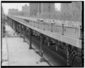 | 4,033 × 5,000 (19.23 מ"ב) | Fæ | GWToolset: Creating mediafile for Fæ. HABS 31 July 2014 (2301:2600) |
שימוש בקובץ
הדף הבא משתמש בקובץ הזה:
שימוש גלובלי בקובץ
אתרי הוויקי השונים הבאים משתמשים בקובץ זה:
- שימוש באתר en.wikipedia.org
- שימוש באתר es.wikipedia.org